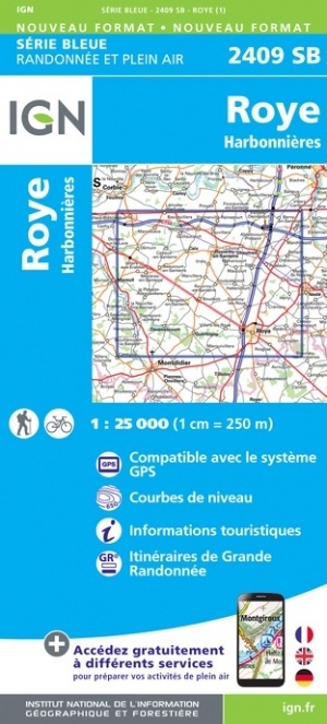
Wandelkaart - Topografische kaart 2409SB Roye | IGN - Institut Géographique National (9782758547303)
Harbonnières
- ISBN / CODE: 9782758547303
- Editie: meest recente versie
- Schaal: 1:25000
- Uitgever: IGN - Institut Géographique National
- Soort: Topografische kaart, Wandelkaart
- Serie: Serie bleue
- Taal: Engels, Frans
- Schrijf als eerste een review
-
€ 16,95
Leverbaar in 3 - 5 werkdagen in huis in Nederland Levertijd Belgie
Gratis verzending in Nederland vanaf €35,-

-
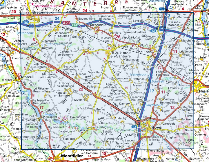
Overzicht IGN 25.000 Pays de Calais - Picardië: Zuid

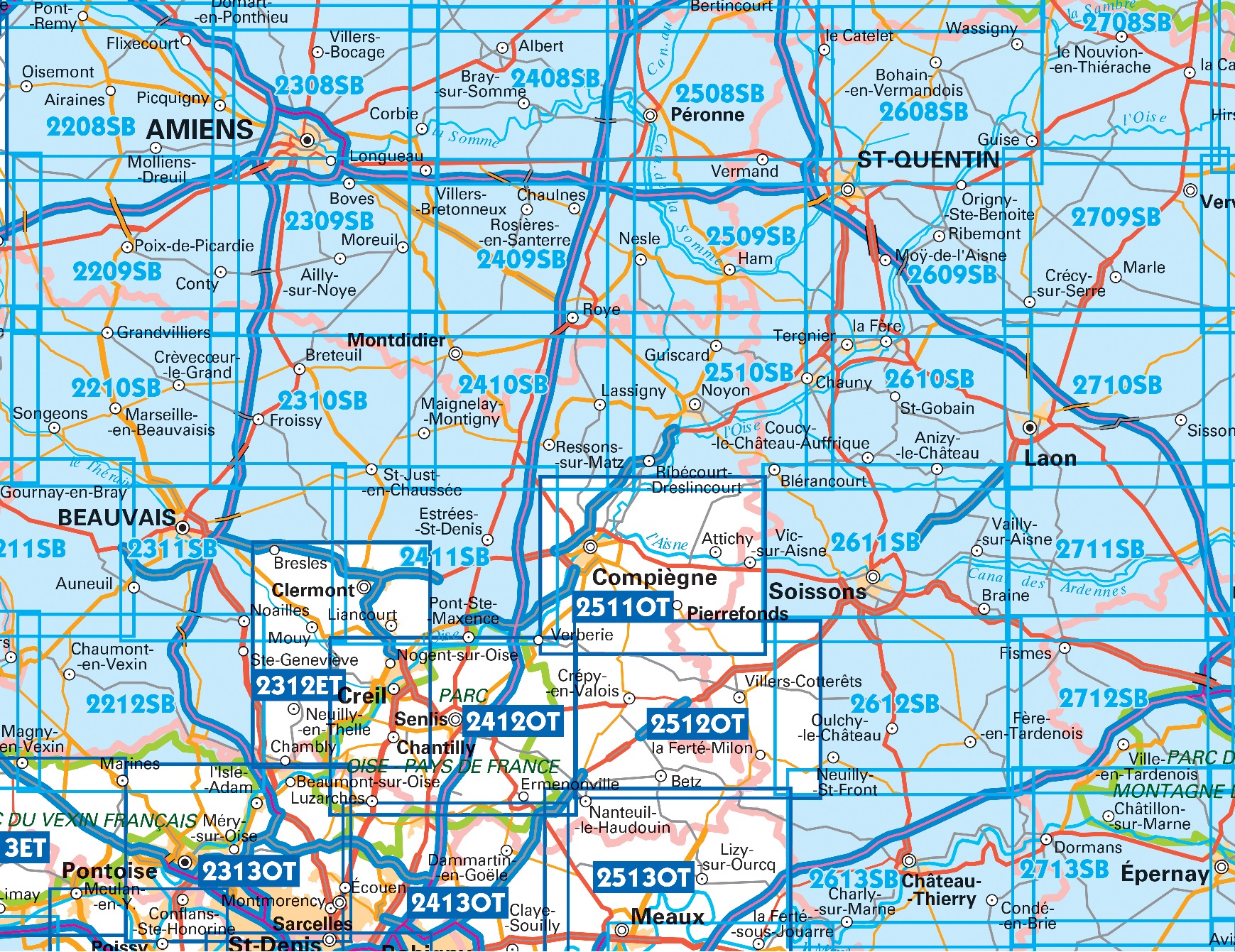
Producten op deze overzichtskaart:
Klik op een product om naar de pagina van dat product te gaan.
- Wandelkaart - Topografische kaart 2208SB Picquigny, Hallencourt, Molliens-Dreuil | IGN - Institut Géographique National
- Wandelkaart - Topografische kaart 2209SB Poix-de-Picardie, Hornoy-le-Bourg | IGN - Institut Géographique National
- Wandelkaart - Topografische kaart 2210SB Crèvecoeur-le-Grand, Grandvilliers | IGN - Institut Géographique National
- Wandelkaart - Topografische kaart 2211SB Gournay-en-Bray , Lachapelle-aux-Pots | IGN - Institut Géographique National
- Wandelkaart - Topografische kaart 2212SB Méru, Chaumont-en-Vexin | IGN - Institut Géographique National
- Wandelkaart - Topografische kaart 2308SB Corbie - Amiens | IGN - Institut Géographique National
- Wandelkaart - Topografische kaart 2309SB Moreuil - Saleux | IGN - Institut Géographique National
- Wandelkaart - Topografische kaart 2310SB Saint-Just-en-Chaussée , Breteuil | IGN - Institut Géographique National
- Wandelkaart - Topografische kaart 2311SB Beauvais - Mouy | IGN - Institut Géographique National
- Wandelkaart - Topografische kaart 2312ET Clermont - Creil | IGN - Institut Géographique National
- Wandelkaart - Topografische kaart 2408SB Bray-sur-Somme, Albert | IGN - Institut Géographique National
- Wandelkaart - Topografische kaart 2409SB Roye | IGN - Institut Géographique National
- Wandelkaart - Topografische kaart 2410SB Ressons-sur-Matz, Montdidier | IGN - Institut Géographique National
- Wandelkaart - Topografische kaart 2411SB Estrées-St-Denis, Clermont | IGN - Institut Géographique National
- Wandelkaart - Topografische kaart 2412OT Forêt de Chantilly | IGN - Institut Géographique National
- Wandelkaart - Topografische kaart 2508SB Roisel - Péronne | IGN - Institut Géographique National
- Wandelkaart - Topografische kaart 2509SB Ham - Nesle | IGN - Institut Géographique National
- Wandelkaart - Topografische kaart 2510SB Chauny - Noyon | IGN - Institut Géographique National
- Wandelkaart - Topografische kaart 2511OT Forêts de Compiègne | IGN - Institut Géographique National
- Wandelkaart - Topografische kaart 2512OT Villers-Cotterêts | IGN - Institut Géographique National
- Wandelkaart - Topografische kaart 2608SB Bohain-en-Vermandois, Guise | IGN - Institut Géographique National
- Wandelkaart - Topografische kaart 2609SB Ribemont - Saint Quentin | IGN - Institut Géographique National
- Wandelkaart - Topografische kaart 2610SB Tergnier, Forêt de St-Gobain et Coucy Basse | IGN - Institut Géographique National
- Wandelkaart - Topografische kaart 2611SB Braine - Soissons | IGN - Institut Géographique National
- Wandelkaart - Topografische kaart 2612SB Fère-en-Tardenois, Neuilly-St-Front | IGN - Institut Géographique National
- Wandelkaart - Topografische kaart 2613SB Château-Thierry, Charly-sur-Marne | IGN - Institut Géographique National
- Wandelkaart - Topografische kaart 2708SB Le Nouvion-en-Thiérache, Avesnes-sur-Helpe | IGN - Institut Géographique National
- Wandelkaart - Topografische kaart 2709SB Vervins - Marie | IGN - Institut Géographique National
- Wandelkaart - Topografische kaart 2710SB Sissonne - Laon | IGN - Institut Géographique National
- Wandelkaart - Topografische kaart 2808SB Hirson - Fourmies | IGN - Institut Géographique National
-
Overzicht IGN 25.000 Pays de Calais - Picardië: Zuid

Producten op deze overzichtskaart:
Klik op een product om naar de pagina van dat product te gaan.
- Wandelkaart - Topografische kaart 2208SB Picquigny, Hallencourt, Molliens-Dreuil | IGN - Institut Géographique National
- Wandelkaart - Topografische kaart 2209SB Poix-de-Picardie, Hornoy-le-Bourg | IGN - Institut Géographique National
- Wandelkaart - Topografische kaart 2210SB Crèvecoeur-le-Grand, Grandvilliers | IGN - Institut Géographique National
- Wandelkaart - Topografische kaart 2211SB Gournay-en-Bray , Lachapelle-aux-Pots | IGN - Institut Géographique National
- Wandelkaart - Topografische kaart 2212SB Méru, Chaumont-en-Vexin | IGN - Institut Géographique National
- Wandelkaart - Topografische kaart 2308SB Corbie - Amiens | IGN - Institut Géographique National
- Wandelkaart - Topografische kaart 2309SB Moreuil - Saleux | IGN - Institut Géographique National
- Wandelkaart - Topografische kaart 2310SB Saint-Just-en-Chaussée , Breteuil | IGN - Institut Géographique National
- Wandelkaart - Topografische kaart 2311SB Beauvais - Mouy | IGN - Institut Géographique National
- Wandelkaart - Topografische kaart 2312ET Clermont - Creil | IGN - Institut Géographique National
- Wandelkaart - Topografische kaart 2408SB Bray-sur-Somme, Albert | IGN - Institut Géographique National
- Wandelkaart - Topografische kaart 2409SB Roye | IGN - Institut Géographique National
- Wandelkaart - Topografische kaart 2410SB Ressons-sur-Matz, Montdidier | IGN - Institut Géographique National
- Wandelkaart - Topografische kaart 2411SB Estrées-St-Denis, Clermont | IGN - Institut Géographique National
- Wandelkaart - Topografische kaart 2412OT Forêt de Chantilly | IGN - Institut Géographique National
- Wandelkaart - Topografische kaart 2508SB Roisel - Péronne | IGN - Institut Géographique National
- Wandelkaart - Topografische kaart 2509SB Ham - Nesle | IGN - Institut Géographique National
- Wandelkaart - Topografische kaart 2510SB Chauny - Noyon | IGN - Institut Géographique National
- Wandelkaart - Topografische kaart 2511OT Forêts de Compiègne | IGN - Institut Géographique National
- Wandelkaart - Topografische kaart 2512OT Villers-Cotterêts | IGN - Institut Géographique National
- Wandelkaart - Topografische kaart 2608SB Bohain-en-Vermandois, Guise | IGN - Institut Géographique National
- Wandelkaart - Topografische kaart 2609SB Ribemont - Saint Quentin | IGN - Institut Géographique National
- Wandelkaart - Topografische kaart 2610SB Tergnier, Forêt de St-Gobain et Coucy Basse | IGN - Institut Géographique National
- Wandelkaart - Topografische kaart 2611SB Braine - Soissons | IGN - Institut Géographique National
- Wandelkaart - Topografische kaart 2612SB Fère-en-Tardenois, Neuilly-St-Front | IGN - Institut Géographique National
- Wandelkaart - Topografische kaart 2613SB Château-Thierry, Charly-sur-Marne | IGN - Institut Géographique National
- Wandelkaart - Topografische kaart 2708SB Le Nouvion-en-Thiérache, Avesnes-sur-Helpe | IGN - Institut Géographique National
- Wandelkaart - Topografische kaart 2709SB Vervins - Marie | IGN - Institut Géographique National
- Wandelkaart - Topografische kaart 2710SB Sissonne - Laon | IGN - Institut Géographique National
- Wandelkaart - Topografische kaart 2808SB Hirson - Fourmies | IGN - Institut Géographique National
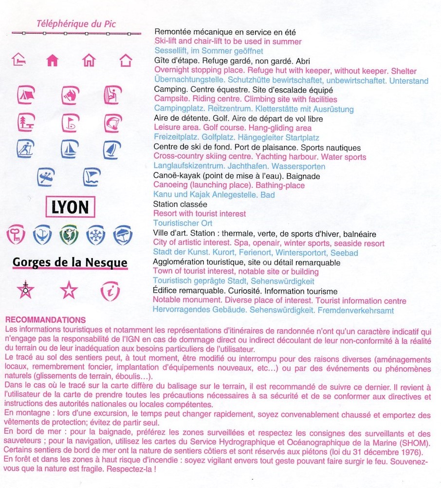
Overzichtskaarten
Beschrijving
Reviews
Geen reviews gevonden voor dit product.
Schrijf een review
Graag horen wij wat u van dit artikel vindt. Vindt u het goed, leuk, mooi, slecht, lelijk, onbruikbaar of erg handig: schrijf gerust alles op! Het is niet alleen leuk om te doen maar u informeert andere klanten er ook nog mee!
Ook interessant voor europa/frankrijk/picardie-nw-frankrijk
-

Wandelkaart - Topografische kaart 25
€ 16,95Topografische kaarten Picardie - Noordwest Frankrijk -

Wandelgids P804 La Côte Picarde - Pi
€ 16,50Wandelgidsen Picardie - Noordwest Frankrijk -

Fietskaart - Wegenkaart - landkaart
€ 10,95Fietskaarten Picardie - Noordwest Frankrijk -

Wandelkaart - Topografische kaart 27
€ 16,95Topografische kaarten Picardie - Noordwest Frankrijk -

Wandelkaart - Topografische kaart 24
€ 16,95Topografische kaarten Picardie - Noordwest Frankrijk