Winkelwagen
Geen items in winkelwagen
Ga naar winkelwagen
Topografische kaarten - Alpen - Queyras
Overzichtskaarten
-
Topografische kaarten IGN 25.000 Hautes Alpes: Queyras
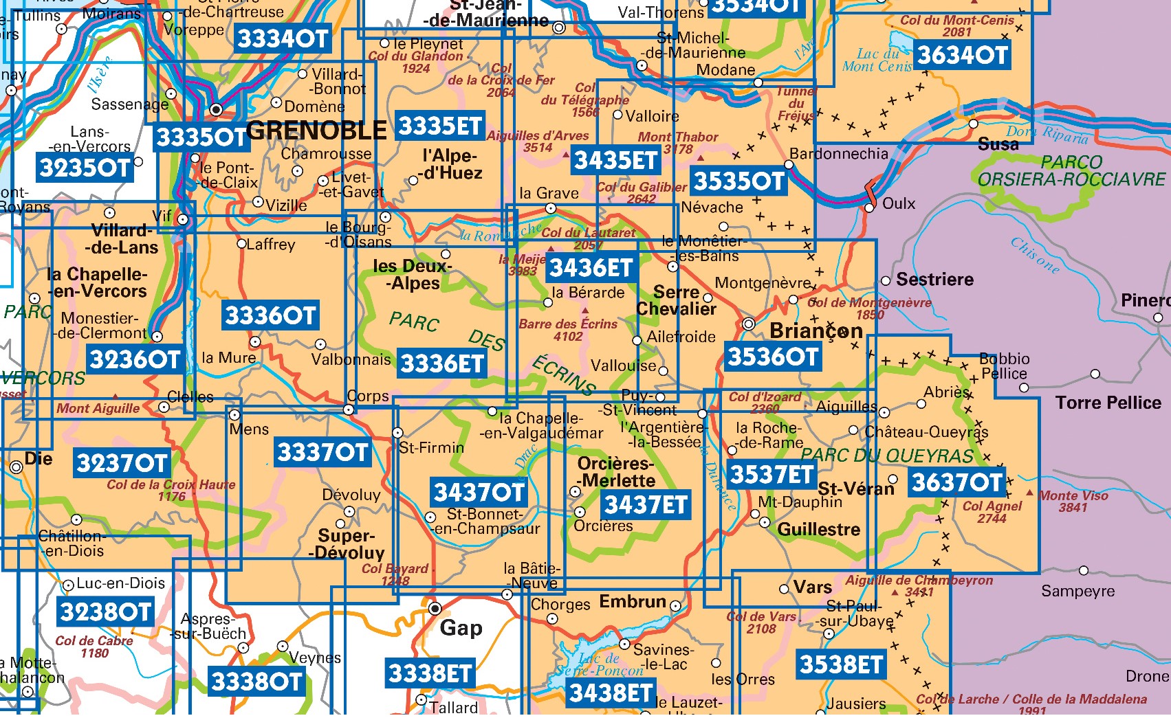
Producten op deze overzichtskaart:
Klik op een product om naar de pagina van dat product te gaan.
- Wandelkaart - Topografische kaart 3438ET Embrun | IGN - Institut Géographique National
- Wandelkaart - Topografische kaart 3536OT Briançon | IGN - Institut Géographique National
- Wandelkaart - Topografische kaart 3537ET Guillestre | IGN - Institut Géographique National
- Wandelkaart - Topografische kaart 3538ET Aiguille de Chamberyron | IGN - Institut Géographique National
- Wandelkaart - Topografische kaart 3637OT Mont Viso | IGN - Institut Géographique National
 Wandelkaart - Topografische kaart 3438ET Embrun | IGN - Institut Géographique National★★★★★
 Wandelkaart - Topografische kaart 3536OT Briançon | IGN - Institut Géographique National★★★★★★★★★★
 Wandelkaart - Topografische kaart 3537ET Guillestre | IGN - Institut Géographique National★★★★★
 Wandelkaart - Topografische kaart 3538ET Aiguille de Chamberyron | IGN - Institut Géographique National
 Wandelkaart - Topografische kaart 3637OT Mont Viso | IGN - Institut Géographique National★★★★★
Laatste reviews

Kaarten zullen zeker van pas komen
De kaarten zijn een cadeau voor onze dochter en onze schoonzoon die met hun kinderen een jaar met de camper gaan “zwerven”. Ze zijn van …
★★★★★ door Pierre van Tits 25 juli 2024 | Heeft dit artikel gekocht
Makkelijk te lezen kaart
Uw landkaarten hebben mij al veel plezier en voorpret bezorgd, ook heb ik inzicht gekregen in de onderlinge afstanden en in verband daarmee mijn reisplanning …
★★★★★ door Wout Breeschoten 25 juli 2024 | Heeft dit artikel gekocht
Veel plezier en voorpret door de kaart
Uw landkaarten hebben mij al veel plezier en voorpret bezorgd, ook heb ik inzicht gekregen in de onderlinge afstanden en in verband daarmee mijn reisplanning …
★★★★★ door Wout Breeschoten 25 juli 2024 | Heeft dit artikel gekocht
Prima kaart
Prima kaart, fijn ook dat hij niet kan scheuren.
★★★★★ door Madeleine Spliet 25 juli 2024 | Heeft dit artikel gekocht