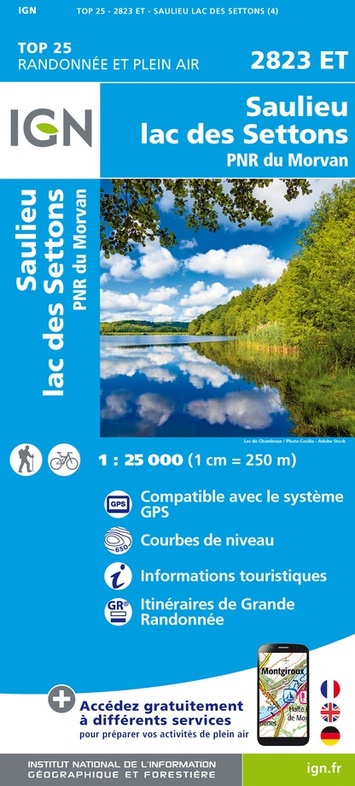
Topografische kaart - Wandelkaart 2823ET Saulieu - Lac de Settons | IGN - Institut Géographique National (9782758552178)
PNR du Morvan
- ISBN / CODE: 9782758552178
- Editie: nieuwste editie
- Schaal: 1:25000
- Uitgever: IGN - Institut Géographique National
- Soort: Topografische kaart, Wandelkaart
- Serie: Top 25
- Taal: Frans
- Uitvoering: Papier
- Bindwijze: -
- Beoordeling: 5,0 ★★★★★ (2 reviews) Schrijf een review
-
€ 16,95
Op voorraad. Voor 17.00 uur op werkdagen besteld, morgen in huis in Nederland Levertijd Belgie
Gratis verzending in Nederland vanaf €35,-
-
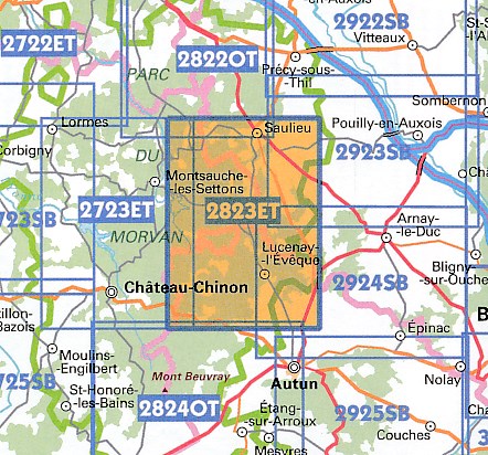
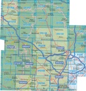
Topografische kaarten IGN 25.000 Bourgondië: OOSTELIJK GEDEELTE + MORVAN

Producten op deze overzichtskaart:
Klik op een product om naar de pagina van dat product te gaan.
- Wandelkaart - Topografische kaart 2719SB Saint-Florentin – Flogny-la-Chapelle | IGN - Institut Géographique National
- Wandelkaart - Topografische kaart 2720SB Chablis, Champs-sur-Yonne | IGN - Institut Géographique National
- Topografische kaart - Wandelkaart 2721SB Vermenton | IGN - Institut Géographique National
- Topografische kaart - Wandelkaart 2722ET Avallon - Vézelay | IGN - Institut Géographique National
- Topografische kaart - Wandelkaart 2723ET Château-Chinon | IGN - Institut Géographique National
- Wandelkaart - Topografische kaart 2723SB Corbigny | IGN - Institut Géographique National
- Topografische kaart - Wandelkaart 2725SB Moulins-Engilbert | IGN - Institut Géographique National
- Topografische kaart - Wandelkaart 2819SB Chaource | IGN - Institut Géographique National
- Topografische kaart - Wandelkaart 2820SB Tonnerre | IGN - Institut Géographique National
- Topografische kaart - Wandelkaart 2821SB L'Isle-sur-Serein | IGN - Institut Géographique National
- Wandelkaart - Topografische kaart 2822OT Quarre-les-Tombes | IGN - Institut Géographique National
- Topografische kaart - Wandelkaart 2823ET Saulieu - Lac de Settons | IGN - Institut Géographique National
- Wandelkaart - Topografische kaart 2824OT Autun - Mont Beuvray | IGN - Institut Géographique National
- Topografische kaart - Wandelkaart 2919SB les Riceys | IGN - Institut Géographique National
- Topografische kaart - Wandelkaart 2920SB Châtillon-sur-Seine | IGN - Institut Géographique National
- Topografische kaart - Wandelkaart 2921SB Baigneux-les-Juifs, Alésia, Montbard | IGN - Institut Géographique National
- Wandelkaart - Topografische kaart 2922SB Semur-en-Auxois – Vitteaux | IGN - Institut Géographique National
- Wandelkaart - Topografische kaart 2923SB Pouilly-en-Auxois – Thoisy-la-Berchère | IGN - Institut Géographique National
- Wandelkaart - Topografische kaart 2924SB Arnay-le-Duc – Epignac | IGN - Institut Géographique National
- Wandelkaart - Topografische kaart 2925SB Autun - Le Creusot | IGN - Institut Géographique National
- Topografische kaart - Wandelkaart 3019SB Châteauvillain | IGN - Institut Géographique National
- Topografische kaart - Wandelkaart 3020SB Recey-sur-Ource | IGN - Institut Géographique National
- Wandelkaart - Topografische kaart 3021SB Grancey-le-Château-Neuvelle – Aignay-le-Duc | IGN - Institut Géographique National
- Wandelkaart - Topografische kaart 3022ET Val-Suzon - St-Seine-l'Abbaye - Dijon Ouest | IGN - Institut Géographique National
- Wandelkaart - Topografische kaart 3023OT Nuits-St-Georges | IGN - Institut Géographique National
- Wandelkaart - Topografische kaart 3024OT Beaune Chagny | IGN - Institut Géographique National
- Wandelkaart - Topografische kaart 3025SB Chalon-sur-Saone (Nord), Chagny | IGN - Institut Géographique National
- Topografische kaart - Wandelkaart 3121SB Is-sur-Tille | IGN - Institut Géographique National
- Wandelkaart - Topografische kaart 3122SB Mirebeau-sur-Bèze | IGN - Institut Géographique National
- Wandelkaart - Topografische kaart 3123SB Dijon | IGN - Institut Géographique National
- Wandelkaart - Topografische kaart 3124SB Seurre | IGN - Institut Géographique National
-
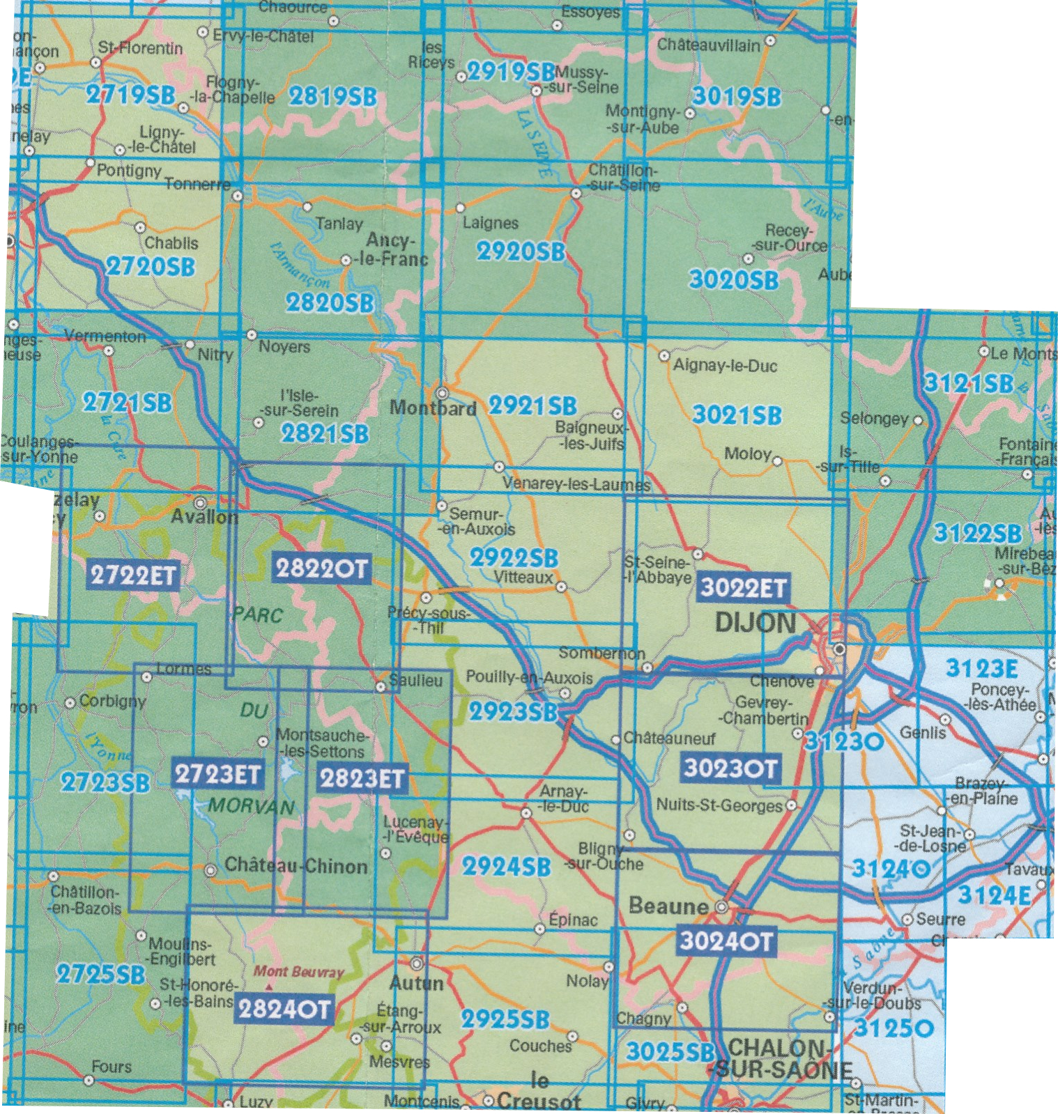
Wandelkaarten IGN 25.000 Bourgondië: OOSTELIJK GEDEELTE + MORVAN

Producten op deze overzichtskaart:
Klik op een product om naar de pagina van dat product te gaan.
- Wandelkaart - Topografische kaart 2719SB Saint-Florentin – Flogny-la-Chapelle | IGN - Institut Géographique National
- Wandelkaart - Topografische kaart 2720SB Chablis, Champs-sur-Yonne | IGN - Institut Géographique National
- Topografische kaart - Wandelkaart 2721SB Vermenton | IGN - Institut Géographique National
- Topografische kaart - Wandelkaart 2722ET Avallon - Vézelay | IGN - Institut Géographique National
- Topografische kaart - Wandelkaart 2723ET Château-Chinon | IGN - Institut Géographique National
- Wandelkaart - Topografische kaart 2723SB Corbigny | IGN - Institut Géographique National
- Topografische kaart - Wandelkaart 2725SB Moulins-Engilbert | IGN - Institut Géographique National
- Topografische kaart - Wandelkaart 2819SB Chaource | IGN - Institut Géographique National
- Topografische kaart - Wandelkaart 2820SB Tonnerre | IGN - Institut Géographique National
- Topografische kaart - Wandelkaart 2821SB L'Isle-sur-Serein | IGN - Institut Géographique National
- Wandelkaart - Topografische kaart 2822OT Quarre-les-Tombes | IGN - Institut Géographique National
- Topografische kaart - Wandelkaart 2823ET Saulieu - Lac de Settons | IGN - Institut Géographique National
- Wandelkaart - Topografische kaart 2824OT Autun - Mont Beuvray | IGN - Institut Géographique National
- Topografische kaart - Wandelkaart 2919SB les Riceys | IGN - Institut Géographique National
- Topografische kaart - Wandelkaart 2920SB Châtillon-sur-Seine | IGN - Institut Géographique National
- Topografische kaart - Wandelkaart 2921SB Baigneux-les-Juifs, Alésia, Montbard | IGN - Institut Géographique National
- Wandelkaart - Topografische kaart 2922SB Semur-en-Auxois – Vitteaux | IGN - Institut Géographique National
- Wandelkaart - Topografische kaart 2923SB Pouilly-en-Auxois – Thoisy-la-Berchère | IGN - Institut Géographique National
- Wandelkaart - Topografische kaart 2924SB Arnay-le-Duc – Epignac | IGN - Institut Géographique National
- Wandelkaart - Topografische kaart 2925SB Autun - Le Creusot | IGN - Institut Géographique National
- Topografische kaart - Wandelkaart 3019SB Châteauvillain | IGN - Institut Géographique National
- Topografische kaart - Wandelkaart 3020SB Recey-sur-Ource | IGN - Institut Géographique National
- Wandelkaart - Topografische kaart 3021SB Grancey-le-Château-Neuvelle – Aignay-le-Duc | IGN - Institut Géographique National
- Wandelkaart - Topografische kaart 3022ET Val-Suzon - St-Seine-l'Abbaye - Dijon Ouest | IGN - Institut Géographique National
- Wandelkaart - Topografische kaart 3023OT Nuits-St-Georges | IGN - Institut Géographique National
- Wandelkaart - Topografische kaart 3024OT Beaune Chagny | IGN - Institut Géographique National
- Wandelkaart - Topografische kaart 3025SB Chalon-sur-Saone (Nord), Chagny | IGN - Institut Géographique National
- Topografische kaart - Wandelkaart 3121SB Is-sur-Tille | IGN - Institut Géographique National
- Wandelkaart - Topografische kaart 3122SB Mirebeau-sur-Bèze | IGN - Institut Géographique National
- Wandelkaart - Topografische kaart 3123SB Dijon | IGN - Institut Géographique National
- Wandelkaart - Topografische kaart 3124SB Seurre | IGN - Institut Géographique National
Overzichtskaarten
Beschrijving
Reviews
Over de bezorging en verzending van de producten zijn we zeer tevreden. Wij gebruiken de wandelkaarten veelvuldig, maar dan is het soms lastig om de kaart heel te houden. Verder is de Zwerver prima, met hun diensten.
★★★★★ door Clemens Huisman 4 november 2014Vond u dit een nuttige review? (login om te beoordelen)
Dit is een wandelkaart uit de serie IGN, waar we al een aantal jaren ervaring mee hebben. De schaal van deze kaart is uitstekend voor wandelingen, maar ook erg handig om met de auto bepaalde toeristische plekken te vinden. Vorig jaar nog in Frankrijk gekocht. Mooi, dat het hier te koop is; dat is goed voor de voorpret!
★★★★★ door A. van Dijk 19 mei 2011Vond u dit een nuttige review? (login om te beoordelen)
Schrijf een review
Graag horen wij wat u van dit artikel vindt. Vindt u het goed, leuk, mooi, slecht, lelijk, onbruikbaar of erg handig: schrijf gerust alles op! Het is niet alleen leuk om te doen maar u informeert andere klanten er ook nog mee!
Ook interessant voor europa/frankrijk/bourgondie
-

Topografische kaart - Wandelkaart 24
€ 16,95Topografische kaarten Bourgondië - Morvan -

Wegenkaart - landkaart 519 Bourgogne
€ 11,95Wegenkaarten Bourgondië - Morvan -

Campergids 14 Mit dem Wohnmobil in B
€ 22,50Campergidsen Bourgondië - Morvan -

Wandelgids P211 Dijon métropole... à
€ 18,50Wandelgidsen Bourgondië - Morvan -

Topografische kaart - Wandelkaart 29
€ 14,95Topografische kaarten Bourgondië - Morvan