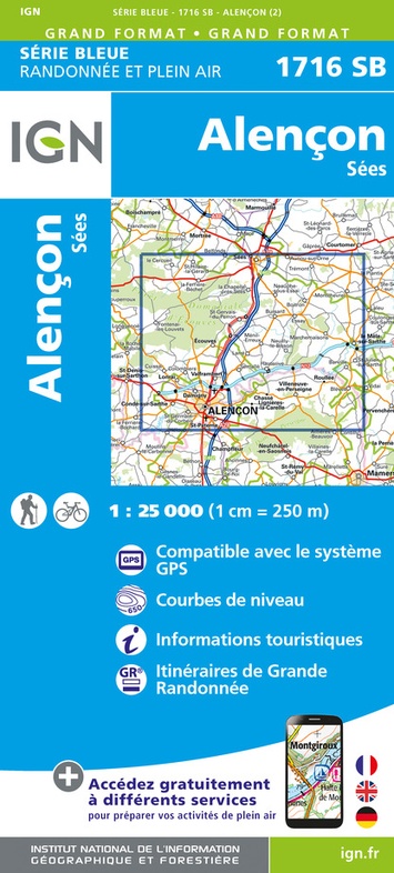
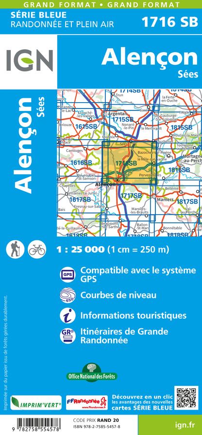
Wandelkaart - Topografische kaart 1716SB Alençon - Sées | IGN - Institut Géographique National (9782758554578)
- ISBN / CODE: 9782758554578
- Editie: 2023
- Schaal: 1:25000
- Uitgever: IGN - Institut Géographique National
- Soort: Topografische kaart, Wandelkaart
- Serie: Serie bleue
- Taal: Frans
- Uitvoering: Papier
- Bindwijze: -
- Schrijf als eerste een review
-
€ 16,95
Leverbaar in 3 - 5 werkdagen in huis in Nederland Levertijd Belgie
Gratis verzending in Nederland vanaf €35,-
-
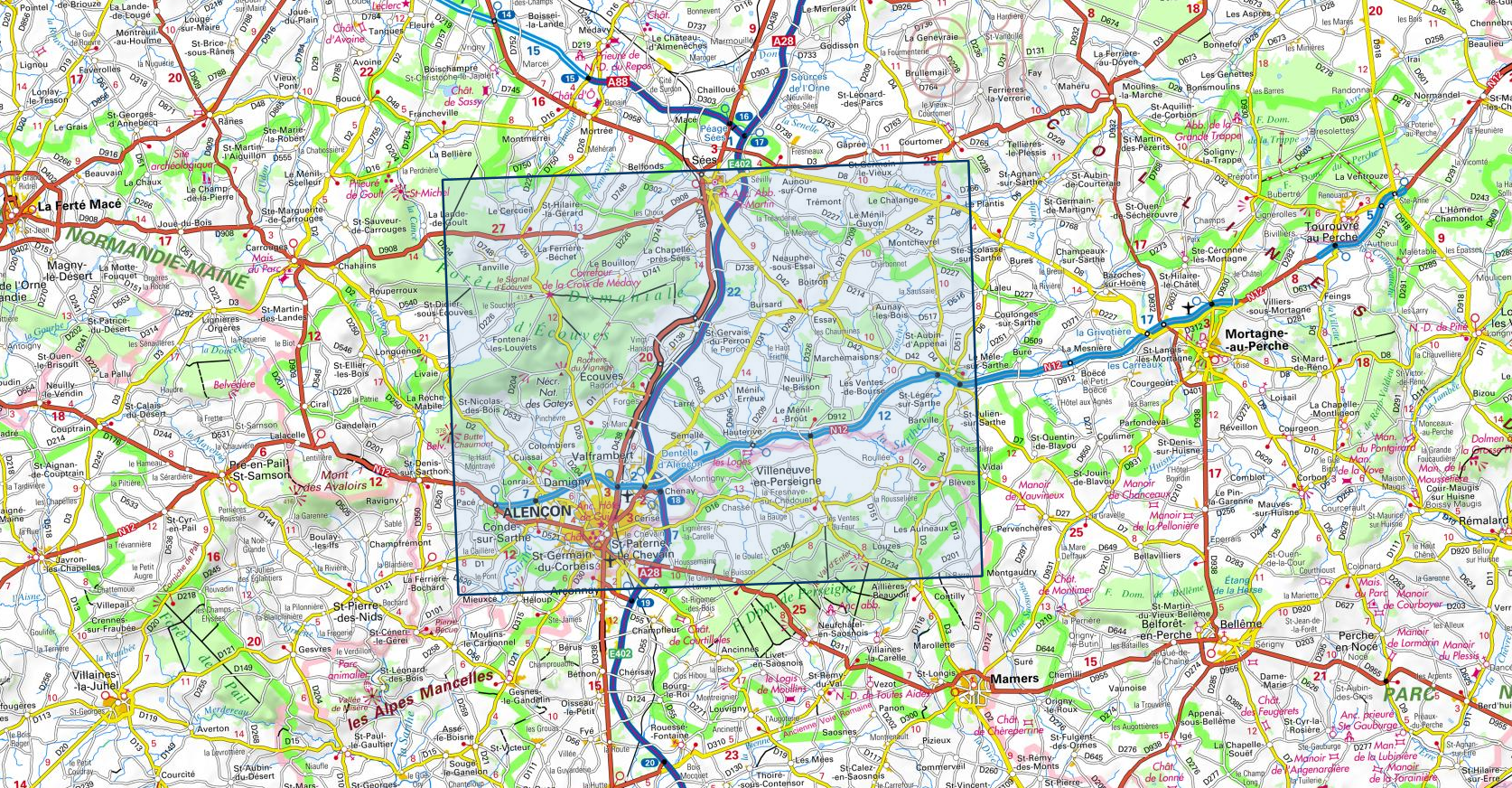
Topografische kaarten IGN 25.000 Normandië: Oost

Producten op deze overzichtskaart:
Klik op een product om naar de pagina van dat product te gaan.
- Topografische kaart - Wandelkaart 1613SB Saint-Pierre-sur-Dives | IGN - Institut Géographique National
- Wandelkaart - Topografische kaart 1614SB Falaise | IGN - Institut Géographique National
- Wandelkaart - Topografische kaart 1615SB Argentan - Putanges-Pont-Ecrepin | IGN - Institut Géographique National
- Wandelkaart - Topografische kaart 1710ET Le Havre, Etretat, PNR des Boucles Seine Normandie | IGN - Institut Géographique National
- Wandelkaart - Topografische kaart 1711OT Honfleur Deauville | IGN - Institut Géographique National
- Wandelkaart - Topografische kaart 1712SB Lisieux - Cambremer | IGN - Institut Géographique National
- Wandelkaart - Topografische kaart 1713SB Livarot - Beuvillers | IGN - Institut Géographique National
- Wandelkaart - Topografische kaart 1714SB Vimoutiers - Trun | IGN - Institut Géographique National
- Wandelkaart - Topografische kaart 1715SB Sées - Gace | IGN - Institut Géographique National
- Wandelkaart - Topografische kaart 1716SB Alençon - Sées | IGN - Institut Géographique National
- Wandelkaart - Topografische kaart 1717SB Alençon - Marolles-les-Braults | IGN - Institut Géographique National
- Wandelkaart - Topografische kaart 1809OT Fecamp, St-Valery-en-Caux, Cote d'Albatre | IGN - Institut Géographique National
- Wandelkaart - Topografische kaart 1810SB Bolbec | IGN - Institut Géographique National
- Wandelkaart - Topografische kaart 1811OT Pont Audemer Tancarville | IGN - Institut Géographique National
- Wandelkaart - Topografische kaart 1812SB Brionne – Cormeilles | IGN - Institut Géographique National
- Wandelkaart - Topografische kaart 1813SB Bernay - Orbec | IGN - Institut Géographique National
- Wandelkaart - Topografische kaart 1814SB Rugles – La Ferté-Frênel | IGN - Institut Géographique National
- Wandelkaart - Topografische kaart 1815SB L'Aigle - Ste-Gauburge - Ste Colombe | IGN - Institut Géographique National
- Wandelkaart - Topografische kaart 1816SB Mortagne-au-Perche - Mêle-sur-Sarthe | IGN - Institut Géographique National
- Wandelkaart - Topografische kaart 1817SB Mamers - Bellême - Le Theil | IGN - Institut Géographique National
- Topografische kaart - Wandelkaart 1909OT St-Valery-en-Caux | IGN - Institut Géographique National
- Wandelkaart - Topografische kaart 1910SB Yvetot | IGN - Institut Géographique National
- Wandelkaart - Topografische kaart 1911ET Rouen, Forets Rouennaises, PNR | IGN - Institut Géographique National
- Wandelkaart - Topografische kaart 1911OT Forets De Brotonne | IGN - Institut Géographique National
- Topografische kaart - Wandelkaart 1912SB Elbeuf | IGN - Institut Géographique National
- Wandelkaart - Topografische kaart 1913SB Evreux - Conches-en-Ouche | IGN - Institut Géographique National
- Wandelkaart - Topografische kaart 1914SB Breteuil – La Neuve-Lyre | IGN - Institut Géographique National
- Wandelkaart - Topografische kaart 2008OT Dieppe - Envermeu - Fresnoy - Folny | IGN - Institut Géographique National
- Topografische kaart - Wandelkaart 2009OT Forêt d'Eawy, Neufchâtel-en-Bray | IGN - Institut Géographique National
- Wandelkaart - Topografische kaart 2010SB Saint-Saëns | IGN - Institut Géographique National
- Wandelkaart - Topografische kaart 2011SB Fleury-sur-Andelle | IGN - Institut Géographique National
- Wandelkaart - Topografische kaart 2012OT Foret De Bord-Louviers | IGN - Institut Géographique National
- Wandelkaart - Topografische kaart 2013SB Evreux - Vernon - Pacy-sur-Eure | IGN - Institut Géographique National
- Wandelkaart - Topografische kaart 2014SB Saint-André-de-l'Eure, Nonancourt | IGN - Institut Géographique National
- Wandelkaart - Topografische kaart 2107OT Le Tréport | IGN - Institut Géographique National
- Wandelkaart - Topografische kaart 2108OT Foret d'Eu, Blangy-sur-Bresle, Gamaches | IGN - Institut Géographique National
- Wandelkaart - Topografische kaart 2109SB Aumale, Neufchâtel-en-Bray | IGN - Institut Géographique National
- Wandelkaart - Topografische kaart 2110SB Formerie, Forges-les-Eaux | IGN - Institut Géographique National
- Wandelkaart - Topografische kaart 2112SB Gisors - Etrépagny | IGN - Institut Géographique National
- Wandelkaart - Topografische kaart 2114SB Houdan - Aubergenville | IGN - Institut Géographique National
-
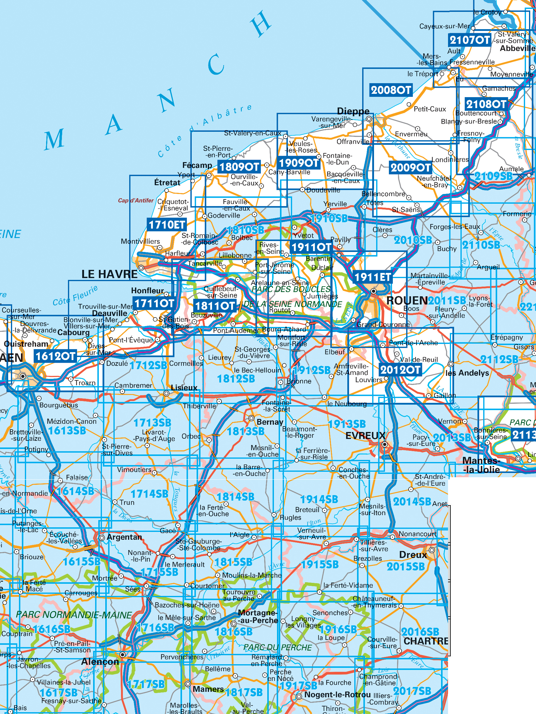
Wandelkaarten IGN 25.000 Normandië: Oost

Producten op deze overzichtskaart:
Klik op een product om naar de pagina van dat product te gaan.
- Topografische kaart - Wandelkaart 1613SB Saint-Pierre-sur-Dives | IGN - Institut Géographique National
- Wandelkaart - Topografische kaart 1614SB Falaise | IGN - Institut Géographique National
- Wandelkaart - Topografische kaart 1615SB Argentan - Putanges-Pont-Ecrepin | IGN - Institut Géographique National
- Wandelkaart - Topografische kaart 1710ET Le Havre, Etretat, PNR des Boucles Seine Normandie | IGN - Institut Géographique National
- Wandelkaart - Topografische kaart 1711OT Honfleur Deauville | IGN - Institut Géographique National
- Wandelkaart - Topografische kaart 1712SB Lisieux - Cambremer | IGN - Institut Géographique National
- Wandelkaart - Topografische kaart 1713SB Livarot - Beuvillers | IGN - Institut Géographique National
- Wandelkaart - Topografische kaart 1714SB Vimoutiers - Trun | IGN - Institut Géographique National
- Wandelkaart - Topografische kaart 1715SB Sées - Gace | IGN - Institut Géographique National
- Wandelkaart - Topografische kaart 1716SB Alençon - Sées | IGN - Institut Géographique National
- Wandelkaart - Topografische kaart 1717SB Alençon - Marolles-les-Braults | IGN - Institut Géographique National
- Wandelkaart - Topografische kaart 1809OT Fecamp, St-Valery-en-Caux, Cote d'Albatre | IGN - Institut Géographique National
- Wandelkaart - Topografische kaart 1810SB Bolbec | IGN - Institut Géographique National
- Wandelkaart - Topografische kaart 1811OT Pont Audemer Tancarville | IGN - Institut Géographique National
- Wandelkaart - Topografische kaart 1812SB Brionne – Cormeilles | IGN - Institut Géographique National
- Wandelkaart - Topografische kaart 1813SB Bernay - Orbec | IGN - Institut Géographique National
- Wandelkaart - Topografische kaart 1814SB Rugles – La Ferté-Frênel | IGN - Institut Géographique National
- Wandelkaart - Topografische kaart 1815SB L'Aigle - Ste-Gauburge - Ste Colombe | IGN - Institut Géographique National
- Wandelkaart - Topografische kaart 1816SB Mortagne-au-Perche - Mêle-sur-Sarthe | IGN - Institut Géographique National
- Wandelkaart - Topografische kaart 1817SB Mamers - Bellême - Le Theil | IGN - Institut Géographique National
- Topografische kaart - Wandelkaart 1909OT St-Valery-en-Caux | IGN - Institut Géographique National
- Wandelkaart - Topografische kaart 1910SB Yvetot | IGN - Institut Géographique National
- Wandelkaart - Topografische kaart 1911ET Rouen, Forets Rouennaises, PNR | IGN - Institut Géographique National
- Wandelkaart - Topografische kaart 1911OT Forets De Brotonne | IGN - Institut Géographique National
- Topografische kaart - Wandelkaart 1912SB Elbeuf | IGN - Institut Géographique National
- Wandelkaart - Topografische kaart 1913SB Evreux - Conches-en-Ouche | IGN - Institut Géographique National
- Wandelkaart - Topografische kaart 1914SB Breteuil – La Neuve-Lyre | IGN - Institut Géographique National
- Wandelkaart - Topografische kaart 2008OT Dieppe - Envermeu - Fresnoy - Folny | IGN - Institut Géographique National
- Topografische kaart - Wandelkaart 2009OT Forêt d'Eawy, Neufchâtel-en-Bray | IGN - Institut Géographique National
- Wandelkaart - Topografische kaart 2010SB Saint-Saëns | IGN - Institut Géographique National
- Wandelkaart - Topografische kaart 2011SB Fleury-sur-Andelle | IGN - Institut Géographique National
- Wandelkaart - Topografische kaart 2012OT Foret De Bord-Louviers | IGN - Institut Géographique National
- Wandelkaart - Topografische kaart 2013SB Evreux - Vernon - Pacy-sur-Eure | IGN - Institut Géographique National
- Wandelkaart - Topografische kaart 2014SB Saint-André-de-l'Eure, Nonancourt | IGN - Institut Géographique National
- Wandelkaart - Topografische kaart 2107OT Le Tréport | IGN - Institut Géographique National
- Wandelkaart - Topografische kaart 2108OT Foret d'Eu, Blangy-sur-Bresle, Gamaches | IGN - Institut Géographique National
- Wandelkaart - Topografische kaart 2109SB Aumale, Neufchâtel-en-Bray | IGN - Institut Géographique National
- Wandelkaart - Topografische kaart 2110SB Formerie, Forges-les-Eaux | IGN - Institut Géographique National
- Wandelkaart - Topografische kaart 2112SB Gisors - Etrépagny | IGN - Institut Géographique National
- Wandelkaart - Topografische kaart 2114SB Houdan - Aubergenville | IGN - Institut Géographique National
Overzichtskaarten
Beschrijving
Reviews
Geen reviews gevonden voor dit product.
Schrijf een review
Graag horen wij wat u van dit artikel vindt. Vindt u het goed, leuk, mooi, slecht, lelijk, onbruikbaar of erg handig: schrijf gerust alles op! Het is niet alleen leuk om te doen maar u informeert andere klanten er ook nog mee!
Ook interessant voor europa/frankrijk/normandie
-

Wegenkaart - landkaart 303 Calvados
€ 9,95Wegenkaarten Normandië -

Campergids 39 Mit dem Wohnmobil durc
€ 24,50Campergidsen Normandië -

Wandelkaart - Topografische kaart 20
€ 16,95Topografische kaarten Normandië -

Reisgids ANWB Ontdek Normandië | ANW
€ 23,50Reisgidsen Normandië -

Wandelgids D061 L'Orne à pied | FFRP
€ 17,95Wandelgidsen Normandië