Winkelwagen
Geen items in winkelwagen
Ga naar winkelwagen
Wandelkaarten - Franche-Comté
 Wandelkaart - Topografische kaart 3319 SB - Serie Bleue Monthureux-sur-Saône - Voisey | IGN - Institut Géographique National
 Wandelkaart 3321 SB - Serie Bleue Port-sur-Saône / Fresne-St-Mamès | IGN - Institut Géographique National
 Wandelkaart - Topografische kaart 3322 SB - Serie Bleue Gy - Rioz | IGN - Institut Géographique National
 Wandelkaart - Topografische kaart 3323ET Besançon - Forêt de Chailluz | IGN - Institut Géographique National
 Wandelkaart - Topografische kaart 3324ET Arc-et-Senans | IGN - Institut Géographique National
 Wandelkaart 3325OT Arbois / Salins-les-Bains / Forêt Domaniale de la Joux | IGN - Institut Géographique National
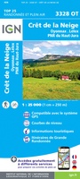 Wandelkaart - Topografische kaart 3328OT Crêt de la Neige | IGN - Institut Géographique National
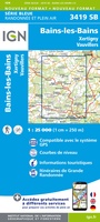 Wandelkaart - Topografische kaart 3419 Bains-les-Bains | IGN - Institut Géographique National
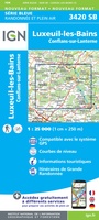 Wandelkaart - Topografische kaart 3420 SB - Serie Bleue Luxeuil-les-Bains, Conflans-sur-Lanterne | IGN - Institut Géographique National
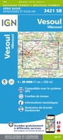 Wandelkaart - Topografische kaart 3421 SB - Serie Bleue Vesoul | IGN - Institut Géographique National
 Wandelkaart - Topografische kaart 3422 SB - Serie Bleue Baume-les-Dames | IGN - Institut Géographique National
 Wandelkaart - Topografische kaart 3423ET Baumes-les-Dames, Vallee du Doubs | IGN - Institut Géographique National
 Wandelkaart - Topografische kaart 3424OT Ornans, Source de la Loue | IGN - Institut Géographique National
 Wandelkaart - Topografische kaart 3425OT Pontarlier | IGN - Institut Géographique National★★★★★
 Wandelkaart - Topografische kaart 3426OT Mouthe - Métabief | IGN - Institut Géographique National★★★★★
 Wandelkaart - Topografische kaart 3429OT Geneve | IGN - Institut Géographique National
 Wandelkaart - Topografische kaart 3122 SB - Serie Bleue Mirebeau-sur-Bèze | IGN - Institut Géographique National
 Wandelkaart - Topografische kaart 3125 SB - Serie Bleue Pierre-de-Bresse, St-Martin-de-Bresse | IGN - Institut Géographique National
 Wandelkaart - Topografische kaart 3128 SB - Serie Bleue Montrevel-en-Bresse, Marboz | IGN - Institut Géographique National
 Wandelkaart - Topografische kaart 3129 SB - Serie Bleue Bourg-en-Bresse | IGN - Institut Géographique National
- 1
- 2
- 3
- Volgende >>
- 4
Laatste reviews

Mooie gedetailleerde kaart
We hebben de kaart nog niet mee op pad genomen maar al wel gebruikt voor de voorbereiding van onze vakantie. De kaart geeft voldoende detail …
★★★★★ door Pieter 02 maart 2026 | Heeft dit artikel gekocht
Fijne stadsplattegrond met duidelijke details
Voor iedere citytrip gebruik ik de stadsplattegronden van Borch. Het is een duidelijke kaart, op goede schaal en fijn dat de kaart geplastificeerd is.
★★★★★ door Mirte 27 februari 2026 | Heeft dit artikel gekocht
Fantastische puzzel
Prachtige puzzel met leuke extra’s, een standaard om de deksel in te zetten. Leuke weetjes over de wijnen aan de binnenkant van de deksel en …
★★★★★ door Angelique de Jonge 26 februari 2026 | Heeft dit artikel gekocht
perfect geleverd en ongeschonden aangekregen
perfect geleverd en ongeschonden aangekregen
★★★★★ door Steven Vansteenkiste 26 februari 2026 | Heeft dit artikel gekocht