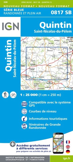
Wandelkaart - Topografische kaart 0817SB Quintin - St-Nicolas-du-Pelem | IGN - Institut Géographique National (9782758552710)
- ISBN / CODE: 9782758552710
- Editie: meest recente versie
- Schaal: 1:25000
- Uitgever: IGN - Institut Géographique National
- Soort: Topografische kaart, Wandelkaart
- Serie: Serie bleue
- Taal: Frans
- Uitvoering: Papier
- Bindwijze: -
- Schrijf als eerste een review
-
€ 16,95
Leverbaar in 3 - 5 werkdagen in huis in Nederland Levertijd Belgie
Gratis verzending in Nederland vanaf €35,-

-
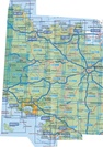
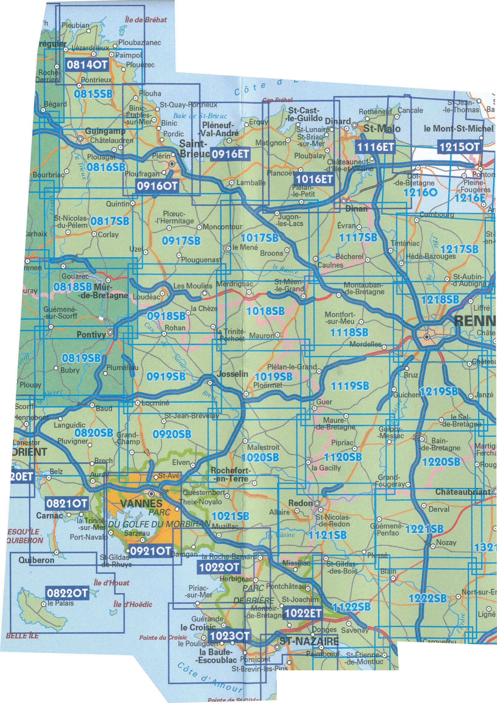
Topografische kaart IGN 25.000 Bretagne MIDDEN GEDEELTE

Producten op deze overzichtskaart:
Klik op een product om naar de pagina van dat product te gaan.
- Topografische kaart - Wandelkaart 0814OT Paimpol | IGN - Institut Géographique National
- Wandelkaart - Topografische kaart 0815SB Paimpol - Pontrieux | IGN - Institut Géographique National
- Wandelkaart - Topografische kaart 0816SB Guingamp | IGN - Institut Géographique National
- Wandelkaart - Topografische kaart 0817SB Quintin - St-Nicolas-du-Pelem | IGN - Institut Géographique National
- Wandelkaart - Topografische kaart 0818SB Pontivy | IGN - Institut Géographique National
- Wandelkaart - Topografische kaart 0819SB Pluméliau | IGN - Institut Géographique National
- Wandelkaart - Topografische kaart 0820SB Baud - Languidic | IGN - Institut Géographique National
- Wandelkaart - Topografische kaart 0821OT Presqu'Ile de Quiberon - Auray - Carnac Bretagne | IGN - Institut Géographique National
- Wandelkaart - Topografische kaart 0822OT Belle-Ile - Ile d'Houat et d'Hoëdic Bretagne | IGN - Institut Géographique National
- Wandelkaart - Topografische kaart 0916ET Erquy - le Val-André | IGN - Institut Géographique National
- Wandelkaart - Topografische kaart 0916OT Saint-Brieuc | IGN - Institut Géographique National
- Wandelkaart - Topografische kaart 0917SB Ploeuc-sur-Lié – Moncontour | IGN - Institut Géographique National
- Topografische kaart - Wandelkaart 0918SB La Trinité-Porhoët, Loudeac | IGN - Institut Géographique National
- Wandelkaart - Topografische kaart 0919SB Locmine - Josselin | IGN - Institut Géographique National
- Wandelkaart - Topografische kaart 0920SB Elven - Grand-Champ | IGN - Institut Géographique National
- Wandelkaart - Topografische kaart 0921OT Vannes | IGN - Institut Géographique National
- Wandelkaart - Topografische kaart 1016ET St.-Cast-le-Guildo - Cap Fréhel | IGN - Institut Géographique National
- Wandelkaart - Topografische kaart 1017SB Broons - Plenee Jugon | IGN - Institut Géographique National
- Wandelkaart - Topografische kaart 1018SB Saint-Méen-le-Grand – Merdrignac | IGN - Institut Géographique National
- Wandelkaart - Topografische kaart 1019SB Paimpont - Ploërmel | IGN - Institut Géographique National
- Wandelkaart - Topografische kaart 1020SB Malestroit - Peillac | IGN - Institut Géographique National
- Wandelkaart - Topografische kaart 1021SB Questembert - La Roche-Bernard | IGN - Institut Géographique National
- Wandelkaart - Topografische kaart 1022ET Saint-Nazaire & Parc Naturel Regional de Briere | IGN - Institut Géographique National
- Wandelkaart - Topografische kaart 1022OT La Roche-Bernard & Parc Naturel Regional de Briere | IGN - Institut Géographique National
- Topografische kaart - Wandelkaart 1023OT La Baule & Parc Naturel Regional de Briere | IGN - Institut Géographique National
- Wandelkaart - Topografische kaart 1116ET Saint-Malo – Dinard – Dinan – Rothéneuf – Cancale – Châteauneuf-d'ille-Vilaine | IGN - Institut Géographique National
- Wandelkaart - Topografische kaart 1117SB Dinan – Caulne -, Tinténiac | IGN - Institut Géographique National
- Wandelkaart - Topografische kaart 1118SB Montfort-sur-Meu – Montauban-de-Bretagne | IGN - Institut Géographique National
- Topografische kaart - Wandelkaart 1119SB Bréal-sous-Montfort, Guer | IGN - Institut Géographique National
- Wandelkaart - Topografische kaart 1120SB Pipriac – La Gacilly | IGN - Institut Géographique National
- Wandelkaart - Topografische kaart 1121SB Redon – St-Gildas-des-Bois | IGN - Institut Géographique National
- Topografische kaart - Wandelkaart 1122SB Savenay | IGN - Institut Géographique National
- Wandelkaart - Topografische kaart 1215OT Le Mont St.-Michel, Dol-de-Bretagne | IGN - Institut Géographique National
- Wandelkaart - Topografische kaart 1216SB Dol-de-Bretagne | IGN - Institut Géographique National
- Wandelkaart - Topografische kaart 1217SB Combourg – St-Aubin-d'Aubigné | IGN - Institut Géographique National
- Wandelkaart - Topografische kaart 1218SB Rennes – Cesson-Sévigné – Liffré | IGN - Institut Géographique National
- Wandelkaart - Topografische kaart 1219SB Bruz - Janzé | IGN - Institut Géographique National
- Wandelkaart - Topografische kaart 1220SB Bain-de-Bretagne – Rougé | IGN - Institut Géographique National
-
Wandelkaart IGN 25.000 Bretagne MIDDEN GEDEELTE

Producten op deze overzichtskaart:
Klik op een product om naar de pagina van dat product te gaan.
- Topografische kaart - Wandelkaart 0814OT Paimpol | IGN - Institut Géographique National
- Wandelkaart - Topografische kaart 0815SB Paimpol - Pontrieux | IGN - Institut Géographique National
- Wandelkaart - Topografische kaart 0816SB Guingamp | IGN - Institut Géographique National
- Wandelkaart - Topografische kaart 0817SB Quintin - St-Nicolas-du-Pelem | IGN - Institut Géographique National
- Wandelkaart - Topografische kaart 0818SB Pontivy | IGN - Institut Géographique National
- Wandelkaart - Topografische kaart 0819SB Pluméliau | IGN - Institut Géographique National
- Wandelkaart - Topografische kaart 0820SB Baud - Languidic | IGN - Institut Géographique National
- Wandelkaart - Topografische kaart 0821OT Presqu'Ile de Quiberon - Auray - Carnac Bretagne | IGN - Institut Géographique National
- Wandelkaart - Topografische kaart 0822OT Belle-Ile - Ile d'Houat et d'Hoëdic Bretagne | IGN - Institut Géographique National
- Wandelkaart - Topografische kaart 0916ET Erquy - le Val-André | IGN - Institut Géographique National
- Wandelkaart - Topografische kaart 0916OT Saint-Brieuc | IGN - Institut Géographique National
- Wandelkaart - Topografische kaart 0917SB Ploeuc-sur-Lié – Moncontour | IGN - Institut Géographique National
- Topografische kaart - Wandelkaart 0918SB La Trinité-Porhoët, Loudeac | IGN - Institut Géographique National
- Wandelkaart - Topografische kaart 0919SB Locmine - Josselin | IGN - Institut Géographique National
- Wandelkaart - Topografische kaart 0920SB Elven - Grand-Champ | IGN - Institut Géographique National
- Wandelkaart - Topografische kaart 0921OT Vannes | IGN - Institut Géographique National
- Wandelkaart - Topografische kaart 1016ET St.-Cast-le-Guildo - Cap Fréhel | IGN - Institut Géographique National
- Wandelkaart - Topografische kaart 1017SB Broons - Plenee Jugon | IGN - Institut Géographique National
- Wandelkaart - Topografische kaart 1018SB Saint-Méen-le-Grand – Merdrignac | IGN - Institut Géographique National
- Wandelkaart - Topografische kaart 1019SB Paimpont - Ploërmel | IGN - Institut Géographique National
- Wandelkaart - Topografische kaart 1020SB Malestroit - Peillac | IGN - Institut Géographique National
- Wandelkaart - Topografische kaart 1021SB Questembert - La Roche-Bernard | IGN - Institut Géographique National
- Wandelkaart - Topografische kaart 1022ET Saint-Nazaire & Parc Naturel Regional de Briere | IGN - Institut Géographique National
- Wandelkaart - Topografische kaart 1022OT La Roche-Bernard & Parc Naturel Regional de Briere | IGN - Institut Géographique National
- Topografische kaart - Wandelkaart 1023OT La Baule & Parc Naturel Regional de Briere | IGN - Institut Géographique National
- Wandelkaart - Topografische kaart 1116ET Saint-Malo – Dinard – Dinan – Rothéneuf – Cancale – Châteauneuf-d'ille-Vilaine | IGN - Institut Géographique National
- Wandelkaart - Topografische kaart 1117SB Dinan – Caulne -, Tinténiac | IGN - Institut Géographique National
- Wandelkaart - Topografische kaart 1118SB Montfort-sur-Meu – Montauban-de-Bretagne | IGN - Institut Géographique National
- Topografische kaart - Wandelkaart 1119SB Bréal-sous-Montfort, Guer | IGN - Institut Géographique National
- Wandelkaart - Topografische kaart 1120SB Pipriac – La Gacilly | IGN - Institut Géographique National
- Wandelkaart - Topografische kaart 1121SB Redon – St-Gildas-des-Bois | IGN - Institut Géographique National
- Topografische kaart - Wandelkaart 1122SB Savenay | IGN - Institut Géographique National
- Wandelkaart - Topografische kaart 1215OT Le Mont St.-Michel, Dol-de-Bretagne | IGN - Institut Géographique National
- Wandelkaart - Topografische kaart 1216SB Dol-de-Bretagne | IGN - Institut Géographique National
- Wandelkaart - Topografische kaart 1217SB Combourg – St-Aubin-d'Aubigné | IGN - Institut Géographique National
- Wandelkaart - Topografische kaart 1218SB Rennes – Cesson-Sévigné – Liffré | IGN - Institut Géographique National
- Wandelkaart - Topografische kaart 1219SB Bruz - Janzé | IGN - Institut Géographique National
- Wandelkaart - Topografische kaart 1220SB Bain-de-Bretagne – Rougé | IGN - Institut Géographique National
Overzichtskaarten
Beschrijving
Reviews
Geen reviews gevonden voor dit product.
Schrijf een review
Graag horen wij wat u van dit artikel vindt. Vindt u het goed, leuk, mooi, slecht, lelijk, onbruikbaar of erg handig: schrijf gerust alles op! Het is niet alleen leuk om te doen maar u informeert andere klanten er ook nog mee!
Ook interessant voor europa/frankrijk/bretagne
-

Campergids Wohnmobil-Tourguide Breta
€ 27,50Campergidsen Bretagne -

Wegenkaart - landkaart 512 Bretagne
€ 11,95Wegenkaarten Bretagne -

Wandelkaart - Topografische kaart 08
€ 16,95Topografische kaarten Bretagne -

Wandelgids P297 De Concarneau à Quim
€ 14,50Wandelgidsen Bretagne -

Fietsgids La Bretagne à vélo | Chami
€ 16,50Fietsgidsen Bretagne