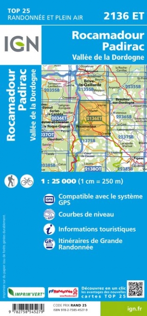
Wandelkaart - Topografische kaart 2136ET Rocamadour, Martel, Gouffre de Padirac, Gramat | IGN - Institut Géographique National (9782758545279)

- ISBN / CODE: 9782758545279
- Editie: nieuwste editie
- Schaal: 1:25000
- Uitgever: IGN - Institut Géographique National
- Soort: Topografische kaart, Wandelkaart
- Serie: Top 25
- Taal: Engels, Frans
- Uitvoering: Papier
- Bindwijze: -
- Beoordeling: 5,0 ★★★★★ (2 reviews) Schrijf een review
-
€ 16,95
Op voorraad. Voor 17.00 uur op werkdagen besteld, morgen in huis in Nederland Levertijd Belgie
Gratis verzending in Nederland vanaf €35,-
-
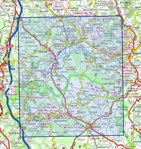
Topografische IGN 25.000 Dordogne - Périgueux - Bergerac - Brive la Gaillarde
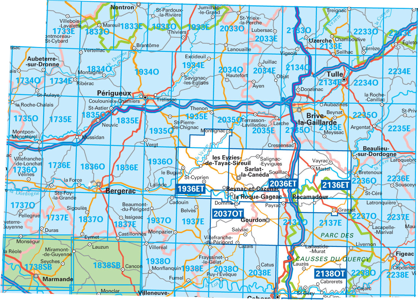
Producten op deze overzichtskaart:
Klik op een product om naar de pagina van dat product te gaan.
- Wandelkaart - Topografische kaart 1733SB Montmoreau-Saint-Cybard | IGN - Institut Géographique National
- Wandelkaart - Topografische kaart 1734SB Ribérac - Chalais | IGN - Institut Géographique National
- Wandelkaart - Topografische kaart 1735SB Montpon-Ménestérol ,Saint-Médard-de-Mussidan | IGN - Institut Géographique National
- Wandelkaart - Topografische kaart 1736SB Ste-Foy-la-Grande, Vélines | IGN - Institut Géographique National
- Wandelkaart - Topografische kaart 1737SB Monségur | IGN - Institut Géographique National
- Wandelkaart - Topografische kaart 1738SB Marmande - Seyches | IGN - Institut Géographique National
- Wandelkaart - Topografische kaart 1833SB Nontron, Brantôme, Mareuil | IGN - Institut Géographique National
- Wandelkaart - Topografische kaart 1834SB Périgueux , Tocane-Saint-Apre | IGN - Institut Géographique National
- Wandelkaart - Topografische kaart 1835SB Villamblard, Saint-Astier, Mussidan | IGN - Institut Géographique National
- Wandelkaart - Topografische kaart 1836SB Creysse - Bergerac | IGN - Institut Géographique National
- Wandelkaart - Topografische kaart 1837SB Eymet - Castillonnès | IGN - Institut Géographique National
- Wandelkaart - Topografische kaart 1838SB Cancon, Miramont-de-Guyenne | IGN - Institut Géographique National
- Wandelkaart - Topografische kaart 1933SB Thiviers, St-Pardoux-la-Rivière | IGN - Institut Géographique National
- Wandelkaart - Topografische kaart 1934SB Excideuil - Périgueux | IGN - Institut Géographique National
- Wandelkaart - Topografische kaart 1935SB Vergt | IGN - Institut Géographique National
- Wandelkaart - Topografische kaart 1936ET Les Eyzies, St.-Cyprien, le Bugue, Beynac | IGN - Institut Géographique National
- Wandelkaart - Topografische kaart 1936SB Lalinde, le Buisson-de-Cadouin | IGN - Institut Géographique National
- Wandelkaart - Topografische kaart 1937SB Belves, Beaumont-du-Périgord | IGN - Institut Géographique National
- Wandelkaart - Topografische kaart 1938SB Fumel - Monflanquin | IGN - Institut Géographique National
- Wandelkaart - Topografische kaart 2033SB Saint-Yrieix-La Perche-Lubersac | IGN - Institut Géographique National
- Wandelkaart - Topografische kaart 2034SB Objat - Hautefort | IGN - Institut Géographique National
- Wandelkaart - Topografische kaart 2035SB Terrasson-Lavilledieu, Montignac, Grotte de Lascaux | IGN - Institut Géographique National
- Wandelkaart - Topografische kaart 2036ET Sarlat-la-Caneda, Souillac | IGN - Institut Géographique National
- Wandelkaart - Topografische kaart 2037OT Roque-Gageac, Domme | IGN - Institut Géographique National
- Wandelkaart - Topografische kaart 2038SB Puy l'Evêque, Luzech | IGN - Institut Géographique National
- Wandelkaart - Topografische kaart 2133SB Uzerche, Treignac, Seilhac | IGN - Institut Géographique National
- Wandelkaart - Topografische kaart 2134SB Tulle | IGN - Institut Géographique National
- Wandelkaart - Topografische kaart 2135SB Beynat, Meyssac, Collonges-la-Rouge, Brive-la-Gaillarde | IGN - Institut Géographique National
- Wandelkaart - Topografische kaart 2136ET Rocamadour, Martel, Gouffre de Padirac, Gramat | IGN - Institut Géographique National
- Wandelkaart - Topografische kaart 2137SB Gramat | IGN - Institut Géographique National
- Wandelkaart - Topografische kaart 2138OT Cahors | IGN - Institut Géographique National
- Wandelkaart - Topografische kaart 2233SB Egletons - Meymac - Corrèze | IGN - Institut Géographique National
- Wandelkaart - Topografische kaart 2234SB Marcillac-la-Croisille, La Roche-Canillac | IGN - Institut Géographique National
- Wandelkaart - Topografische kaart 2235SB Argentat-sur-Dordogne | IGN - Institut Géographique National
- Wandelkaart - Topografische kaart 2236SB Saint-Céré, Sousceyrac-en-Quercy | IGN - Institut Géographique National
- Wandelkaart - Topografische kaart 2237SB Latronquière, Lacapelle-Marival | IGN - Institut Géographique National
- Wandelkaart - Topografische kaart 2238SB Figeac | IGN - Institut Géographique National
-
Wandelkaarten IGN 25.000 Dordogne - Périgueux - Bergerac - Brive la Gaillarde


Producten op deze overzichtskaart:
Klik op een product om naar de pagina van dat product te gaan.
- Wandelkaart - Topografische kaart 1733SB Montmoreau-Saint-Cybard | IGN - Institut Géographique National
- Wandelkaart - Topografische kaart 1734SB Ribérac - Chalais | IGN - Institut Géographique National
- Wandelkaart - Topografische kaart 1735SB Montpon-Ménestérol ,Saint-Médard-de-Mussidan | IGN - Institut Géographique National
- Wandelkaart - Topografische kaart 1736SB Ste-Foy-la-Grande, Vélines | IGN - Institut Géographique National
- Wandelkaart - Topografische kaart 1737SB Monségur | IGN - Institut Géographique National
- Wandelkaart - Topografische kaart 1738SB Marmande - Seyches | IGN - Institut Géographique National
- Wandelkaart - Topografische kaart 1833SB Nontron, Brantôme, Mareuil | IGN - Institut Géographique National
- Wandelkaart - Topografische kaart 1834SB Périgueux , Tocane-Saint-Apre | IGN - Institut Géographique National
- Wandelkaart - Topografische kaart 1835SB Villamblard, Saint-Astier, Mussidan | IGN - Institut Géographique National
- Wandelkaart - Topografische kaart 1836SB Creysse - Bergerac | IGN - Institut Géographique National
- Wandelkaart - Topografische kaart 1837SB Eymet - Castillonnès | IGN - Institut Géographique National
- Wandelkaart - Topografische kaart 1838SB Cancon, Miramont-de-Guyenne | IGN - Institut Géographique National
- Wandelkaart - Topografische kaart 1933SB Thiviers, St-Pardoux-la-Rivière | IGN - Institut Géographique National
- Wandelkaart - Topografische kaart 1934SB Excideuil - Périgueux | IGN - Institut Géographique National
- Wandelkaart - Topografische kaart 1935SB Vergt | IGN - Institut Géographique National
- Wandelkaart - Topografische kaart 1936ET Les Eyzies, St.-Cyprien, le Bugue, Beynac | IGN - Institut Géographique National
- Wandelkaart - Topografische kaart 1936SB Lalinde, le Buisson-de-Cadouin | IGN - Institut Géographique National
- Wandelkaart - Topografische kaart 1937SB Belves, Beaumont-du-Périgord | IGN - Institut Géographique National
- Wandelkaart - Topografische kaart 1938SB Fumel - Monflanquin | IGN - Institut Géographique National
- Wandelkaart - Topografische kaart 2033SB Saint-Yrieix-La Perche-Lubersac | IGN - Institut Géographique National
- Wandelkaart - Topografische kaart 2034SB Objat - Hautefort | IGN - Institut Géographique National
- Wandelkaart - Topografische kaart 2035SB Terrasson-Lavilledieu, Montignac, Grotte de Lascaux | IGN - Institut Géographique National
- Wandelkaart - Topografische kaart 2036ET Sarlat-la-Caneda, Souillac | IGN - Institut Géographique National
- Wandelkaart - Topografische kaart 2037OT Roque-Gageac, Domme | IGN - Institut Géographique National
- Wandelkaart - Topografische kaart 2038SB Puy l'Evêque, Luzech | IGN - Institut Géographique National
- Wandelkaart - Topografische kaart 2133SB Uzerche, Treignac, Seilhac | IGN - Institut Géographique National
- Wandelkaart - Topografische kaart 2134SB Tulle | IGN - Institut Géographique National
- Wandelkaart - Topografische kaart 2135SB Beynat, Meyssac, Collonges-la-Rouge, Brive-la-Gaillarde | IGN - Institut Géographique National
- Wandelkaart - Topografische kaart 2136ET Rocamadour, Martel, Gouffre de Padirac, Gramat | IGN - Institut Géographique National
- Wandelkaart - Topografische kaart 2137SB Gramat | IGN - Institut Géographique National
- Wandelkaart - Topografische kaart 2138OT Cahors | IGN - Institut Géographique National
- Wandelkaart - Topografische kaart 2233SB Egletons - Meymac - Corrèze | IGN - Institut Géographique National
- Wandelkaart - Topografische kaart 2234SB Marcillac-la-Croisille, La Roche-Canillac | IGN - Institut Géographique National
- Wandelkaart - Topografische kaart 2235SB Argentat-sur-Dordogne | IGN - Institut Géographique National
- Wandelkaart - Topografische kaart 2236SB Saint-Céré, Sousceyrac-en-Quercy | IGN - Institut Géographique National
- Wandelkaart - Topografische kaart 2237SB Latronquière, Lacapelle-Marival | IGN - Institut Géographique National
- Wandelkaart - Topografische kaart 2238SB Figeac | IGN - Institut Géographique National
Overzichtskaarten
Beschrijving
De wandelkaart die de perfectie benadert! Werkelijk alle topografische details zijn er op te vinden; van hoogtelijnen tot aan bruggetjes en allerlei wandelpaden. Daarnaast hebben de makers een flinke dosis toeristische informatie op de kaart verwerkt: campings, gites d étape, restaurants en ingetekende doorgaande wandelpaden, de grandes randonnées. Het kleurgebruik is geweldig met schaduwzijdes, bos, weiland, etc goed te onderscheiden. De kaart is uitgevoerd met raster van graden, dus deze is GPS - toepasbaar!
Reviews
Uitstekende kaart, zeer gedetailleerd en geschikt om zelf wandelingen uit te zetten.
★★★★★ door Arie Stougie 24 augustus 2020 | Heeft dit artikel gekochtVond u dit een nuttige review? (login om te beoordelen)
Super gedetaileerde kaart,uitstekend voor wandelingen
★★★★★ door Neyt Paul 29 mei 2011Vond u dit een nuttige review? (login om te beoordelen)
Schrijf een review
Graag horen wij wat u van dit artikel vindt. Vindt u het goed, leuk, mooi, slecht, lelijk, onbruikbaar of erg handig: schrijf gerust alles op! Het is niet alleen leuk om te doen maar u informeert andere klanten er ook nog mee!
Ook interessant voor europa/frankrijk/dordogne
-

Wandelkaart - Topografische kaart 22
€ 16,95Topografische kaarten Dordogne - Limousin -

Wandelkaart - Topografische kaart 19
€ 16,95Topografische kaarten Dordogne - Limousin -

Wandelkaart - Topografische kaart 21
€ 16,95Topografische kaarten Dordogne - Limousin -

Wandelkaart - Topografische kaart 18
€ 16,95Topografische kaarten Dordogne - Limousin -

Wandelkaart - Topografische kaart 20
€ 16,95Topografische kaarten Dordogne - Limousin