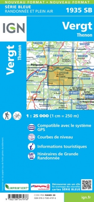
Wandelkaart - Topografische kaart 1935SB Vergt | IGN - Institut Géographique National (9782758547976)
Thenon

- ISBN / CODE: 9782758547976
- Editie: meest recente editie
- Schaal: 1:25000
- Uitgever: IGN - Institut Géographique National
- Soort: Topografische kaart, Wandelkaart
- Serie: Serie bleue
- Taal: Engels, Frans
- Schrijf als eerste een review
-
€ 16,95
Leverbaar in 3 - 5 werkdagen in huis in Nederland Levertijd Belgie
Gratis verzending in Nederland vanaf €35,-

-
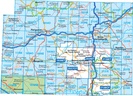
Topografische IGN 25.000 Dordogne - Périgueux - Bergerac - Brive la Gaillarde
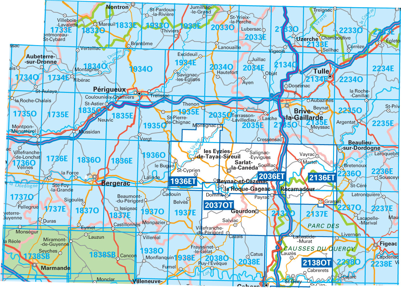
Producten op deze overzichtskaart:
Klik op een product om naar de pagina van dat product te gaan.
- Wandelkaart - Topografische kaart 1733SB Montmoreau-Saint-Cybard | IGN - Institut Géographique National
- Wandelkaart - Topografische kaart 1734SB Ribérac - Chalais | IGN - Institut Géographique National
- Wandelkaart - Topografische kaart 1735SB Montpon-Ménestérol ,Saint-Médard-de-Mussidan | IGN - Institut Géographique National
- Wandelkaart - Topografische kaart 1736SB Ste-Foy-la-Grande, Vélines | IGN - Institut Géographique National
- Wandelkaart - Topografische kaart 1737SB Monségur | IGN - Institut Géographique National
- Wandelkaart - Topografische kaart 1738SB Marmande - Seyches | IGN - Institut Géographique National
- Wandelkaart - Topografische kaart 1833SB Nontron, Brantôme, Mareuil | IGN - Institut Géographique National
- Wandelkaart - Topografische kaart 1834SB Périgueux , Tocane-Saint-Apre | IGN - Institut Géographique National
- Wandelkaart - Topografische kaart 1835SB Villamblard, Saint-Astier, Mussidan | IGN - Institut Géographique National
- Wandelkaart - Topografische kaart 1836SB Creysse - Bergerac | IGN - Institut Géographique National
- Wandelkaart - Topografische kaart 1837SB Eymet - Castillonnès | IGN - Institut Géographique National
- Wandelkaart - Topografische kaart 1838SB Cancon, Miramont-de-Guyenne | IGN - Institut Géographique National
- Wandelkaart - Topografische kaart 1933SB Thiviers, St-Pardoux-la-Rivière | IGN - Institut Géographique National
- Wandelkaart - Topografische kaart 1934SB Excideuil - Périgueux | IGN - Institut Géographique National
- Wandelkaart - Topografische kaart 1935SB Vergt | IGN - Institut Géographique National
- Wandelkaart - Topografische kaart 1936ET Les Eyzies, St.-Cyprien, le Bugue, Beynac | IGN - Institut Géographique National
- Wandelkaart - Topografische kaart 1936SB Lalinde, le Buisson-de-Cadouin | IGN - Institut Géographique National
- Wandelkaart - Topografische kaart 1937SB Belves, Beaumont-du-Périgord | IGN - Institut Géographique National
- Wandelkaart - Topografische kaart 1938SB Fumel - Monflanquin | IGN - Institut Géographique National
- Wandelkaart - Topografische kaart 2033SB Saint-Yrieix-La Perche-Lubersac | IGN - Institut Géographique National
- Wandelkaart - Topografische kaart 2034SB Objat - Hautefort | IGN - Institut Géographique National
- Wandelkaart - Topografische kaart 2035SB Terrasson-Lavilledieu, Montignac, Grotte de Lascaux | IGN - Institut Géographique National
- Wandelkaart - Topografische kaart 2036ET Sarlat-la-Caneda, Souillac | IGN - Institut Géographique National
- Wandelkaart - Topografische kaart 2037OT Roque-Gageac, Domme | IGN - Institut Géographique National
- Wandelkaart - Topografische kaart 2038SB Puy l'Evêque, Luzech | IGN - Institut Géographique National
- Wandelkaart - Topografische kaart 2133SB Uzerche, Treignac, Seilhac | IGN - Institut Géographique National
- Wandelkaart - Topografische kaart 2134SB Tulle | IGN - Institut Géographique National
- Wandelkaart - Topografische kaart 2135SB Beynat, Meyssac, Collonges-la-Rouge, Brive-la-Gaillarde | IGN - Institut Géographique National
- Wandelkaart - Topografische kaart 2136ET Rocamadour, Martel, Gouffre de Padirac, Gramat | IGN - Institut Géographique National
- Wandelkaart - Topografische kaart 2137SB Gramat | IGN - Institut Géographique National
- Wandelkaart - Topografische kaart 2138OT Cahors | IGN - Institut Géographique National
- Wandelkaart - Topografische kaart 2233SB Egletons - Meymac - Corrèze | IGN - Institut Géographique National
- Wandelkaart - Topografische kaart 2234SB Marcillac-la-Croisille, La Roche-Canillac | IGN - Institut Géographique National
- Wandelkaart - Topografische kaart 2235SB Argentat-sur-Dordogne | IGN - Institut Géographique National
- Wandelkaart - Topografische kaart 2236SB Saint-Céré, Sousceyrac-en-Quercy | IGN - Institut Géographique National
- Wandelkaart - Topografische kaart 2237SB Latronquière, Lacapelle-Marival | IGN - Institut Géographique National
- Wandelkaart - Topografische kaart 2238SB Figeac | IGN - Institut Géographique National
-
Wandelkaarten IGN 25.000 Dordogne - Périgueux - Bergerac - Brive la Gaillarde


Producten op deze overzichtskaart:
Klik op een product om naar de pagina van dat product te gaan.
- Wandelkaart - Topografische kaart 1733SB Montmoreau-Saint-Cybard | IGN - Institut Géographique National
- Wandelkaart - Topografische kaart 1734SB Ribérac - Chalais | IGN - Institut Géographique National
- Wandelkaart - Topografische kaart 1735SB Montpon-Ménestérol ,Saint-Médard-de-Mussidan | IGN - Institut Géographique National
- Wandelkaart - Topografische kaart 1736SB Ste-Foy-la-Grande, Vélines | IGN - Institut Géographique National
- Wandelkaart - Topografische kaart 1737SB Monségur | IGN - Institut Géographique National
- Wandelkaart - Topografische kaart 1738SB Marmande - Seyches | IGN - Institut Géographique National
- Wandelkaart - Topografische kaart 1833SB Nontron, Brantôme, Mareuil | IGN - Institut Géographique National
- Wandelkaart - Topografische kaart 1834SB Périgueux , Tocane-Saint-Apre | IGN - Institut Géographique National
- Wandelkaart - Topografische kaart 1835SB Villamblard, Saint-Astier, Mussidan | IGN - Institut Géographique National
- Wandelkaart - Topografische kaart 1836SB Creysse - Bergerac | IGN - Institut Géographique National
- Wandelkaart - Topografische kaart 1837SB Eymet - Castillonnès | IGN - Institut Géographique National
- Wandelkaart - Topografische kaart 1838SB Cancon, Miramont-de-Guyenne | IGN - Institut Géographique National
- Wandelkaart - Topografische kaart 1933SB Thiviers, St-Pardoux-la-Rivière | IGN - Institut Géographique National
- Wandelkaart - Topografische kaart 1934SB Excideuil - Périgueux | IGN - Institut Géographique National
- Wandelkaart - Topografische kaart 1935SB Vergt | IGN - Institut Géographique National
- Wandelkaart - Topografische kaart 1936ET Les Eyzies, St.-Cyprien, le Bugue, Beynac | IGN - Institut Géographique National
- Wandelkaart - Topografische kaart 1936SB Lalinde, le Buisson-de-Cadouin | IGN - Institut Géographique National
- Wandelkaart - Topografische kaart 1937SB Belves, Beaumont-du-Périgord | IGN - Institut Géographique National
- Wandelkaart - Topografische kaart 1938SB Fumel - Monflanquin | IGN - Institut Géographique National
- Wandelkaart - Topografische kaart 2033SB Saint-Yrieix-La Perche-Lubersac | IGN - Institut Géographique National
- Wandelkaart - Topografische kaart 2034SB Objat - Hautefort | IGN - Institut Géographique National
- Wandelkaart - Topografische kaart 2035SB Terrasson-Lavilledieu, Montignac, Grotte de Lascaux | IGN - Institut Géographique National
- Wandelkaart - Topografische kaart 2036ET Sarlat-la-Caneda, Souillac | IGN - Institut Géographique National
- Wandelkaart - Topografische kaart 2037OT Roque-Gageac, Domme | IGN - Institut Géographique National
- Wandelkaart - Topografische kaart 2038SB Puy l'Evêque, Luzech | IGN - Institut Géographique National
- Wandelkaart - Topografische kaart 2133SB Uzerche, Treignac, Seilhac | IGN - Institut Géographique National
- Wandelkaart - Topografische kaart 2134SB Tulle | IGN - Institut Géographique National
- Wandelkaart - Topografische kaart 2135SB Beynat, Meyssac, Collonges-la-Rouge, Brive-la-Gaillarde | IGN - Institut Géographique National
- Wandelkaart - Topografische kaart 2136ET Rocamadour, Martel, Gouffre de Padirac, Gramat | IGN - Institut Géographique National
- Wandelkaart - Topografische kaart 2137SB Gramat | IGN - Institut Géographique National
- Wandelkaart - Topografische kaart 2138OT Cahors | IGN - Institut Géographique National
- Wandelkaart - Topografische kaart 2233SB Egletons - Meymac - Corrèze | IGN - Institut Géographique National
- Wandelkaart - Topografische kaart 2234SB Marcillac-la-Croisille, La Roche-Canillac | IGN - Institut Géographique National
- Wandelkaart - Topografische kaart 2235SB Argentat-sur-Dordogne | IGN - Institut Géographique National
- Wandelkaart - Topografische kaart 2236SB Saint-Céré, Sousceyrac-en-Quercy | IGN - Institut Géographique National
- Wandelkaart - Topografische kaart 2237SB Latronquière, Lacapelle-Marival | IGN - Institut Géographique National
- Wandelkaart - Topografische kaart 2238SB Figeac | IGN - Institut Géographique National
Overzichtskaarten
Beschrijving
Reviews
Geen reviews gevonden voor dit product.
Schrijf een review
Graag horen wij wat u van dit artikel vindt. Vindt u het goed, leuk, mooi, slecht, lelijk, onbruikbaar of erg handig: schrijf gerust alles op! Het is niet alleen leuk om te doen maar u informeert andere klanten er ook nog mee!
Ook interessant voor europa/frankrijk/dordogne
-

Reisgids ANWB extra Dordogne | ANWB
€ 15,50Reisgidsen Dordogne - Limousin -

Wandelgids walking in the Dordogne |
€ 20,95Wandelgidsen Dordogne - Limousin -

Fietskaart - Wegenkaart - landkaart
€ 10,95Fietskaarten Dordogne - Limousin -

Wandelkaart - Topografische kaart 19
€ 16,95Topografische kaarten Dordogne - Limousin -

Reisgids Michelin groene gids Dordog
€ 22,99Reisgidsen Dordogne - Limousin