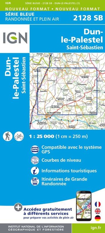
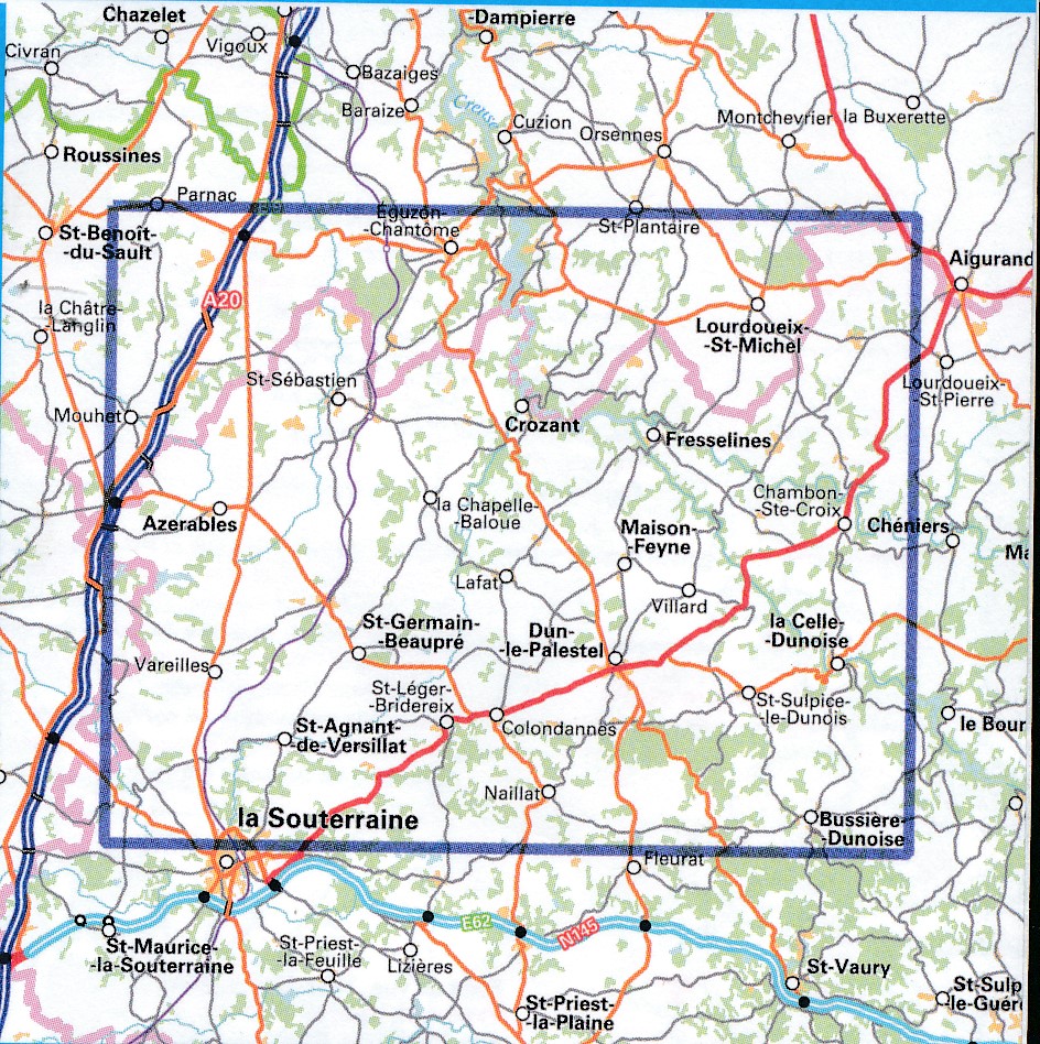
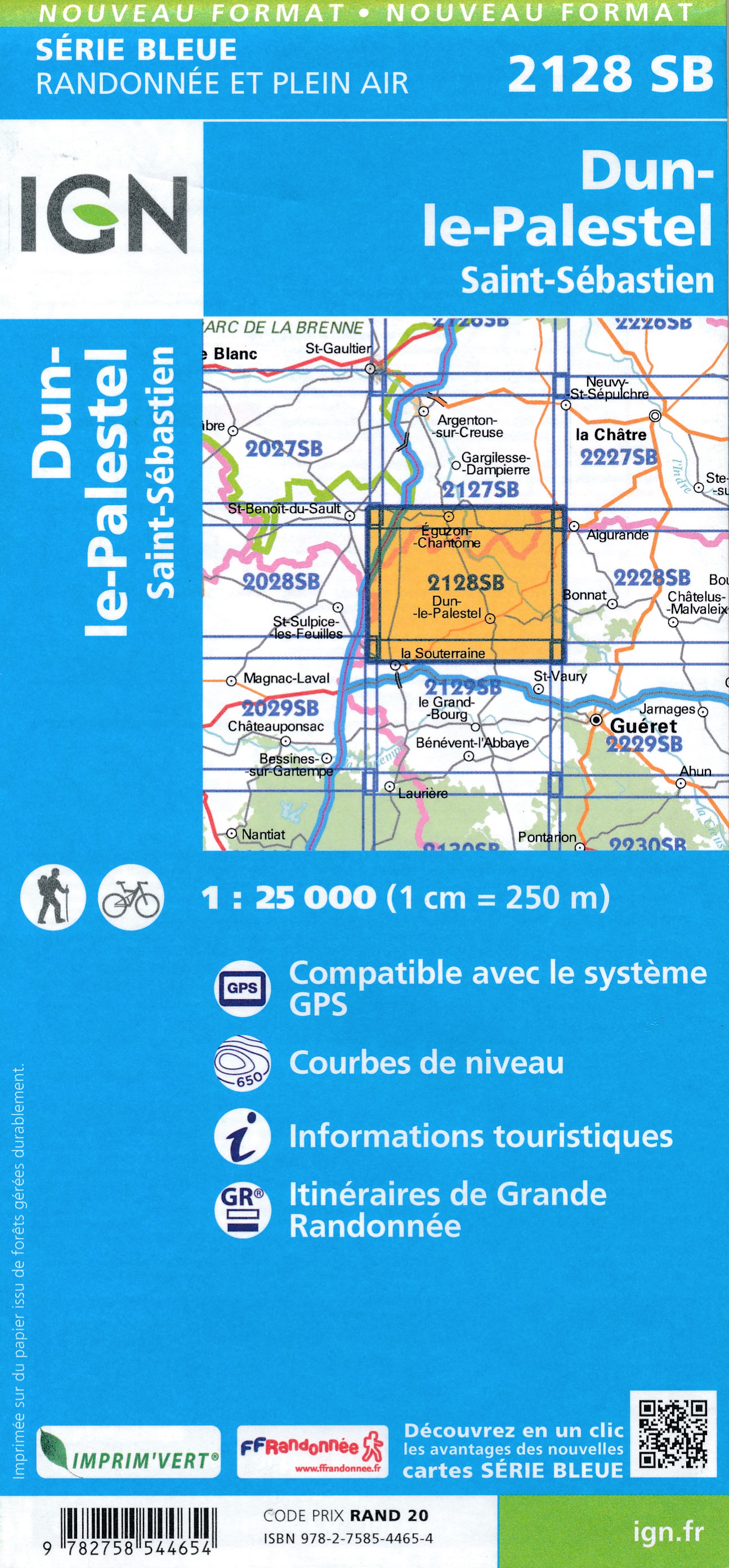
Wandelkaart - Topografische kaart 2128SB Dun-le-Palestel | IGN - Institut Géographique National (9782758544654)
Saint Sebastien
- ISBN / CODE: 9782758544654
- Editie: meest recente versie
- Schaal: 1:25000
- Uitgever: IGN - Institut Géographique National
- Soort: Topografische kaart, Wandelkaart
- Serie: Serie bleue
- Taal: Engels, Frans
- Beoordeling: 5,0 ★★★★★ (1 review) Schrijf een review
-
€ 16,95
Dit artikel is (tijdelijk) niet leverbaar
-
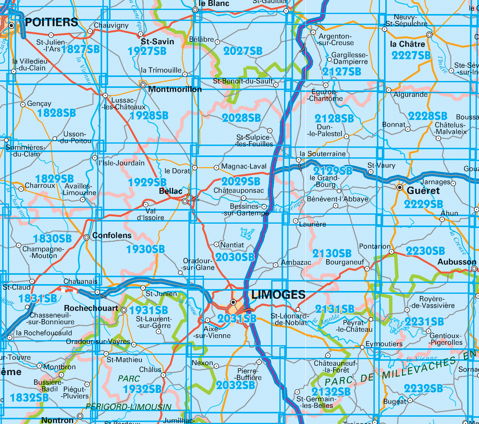
Topografische kaarten IGN 25.000 Limousin - Limoges


Producten op deze overzichtskaart:
Klik op een product om naar de pagina van dat product te gaan.
- Wandelkaart - Topografische kaart 1828SB Gençay - Persac | IGN - Institut Géographique National
- Wandelkaart - Topografische kaart 1829SB L'Isle-Jourdain - Charroux | IGN - Institut Géographique National
- Wandelkaart - Topografische kaart 1830SB Confolens | IGN - Institut Géographique National
- Wandelkaart - Topografische kaart 1831SB Rochefoucauld - Exideuil | IGN - Institut Géographique National
- Wandelkaart - Topografische kaart 1832SB Montbron, Piégut-Pluviers | IGN - Institut Géographique National
- Wandelkaart - Topografische kaart 1927SB La Trimouille | IGN - Institut Géographique National
- Wandelkaart - Topografische kaart 1928SB Montmorillon, Lathus-St-Rémy | IGN - Institut Géographique National
- Wandelkaart - Topografische kaart 1929SB Bellac - Adriers | IGN - Institut Géographique National
- Wandelkaart - Topografische kaart 1930SB Oradour-sur-Glane | IGN - Institut Géographique National
- Wandelkaart - Topografische kaart 1931SB Rochechouart | IGN - Institut Géographique National
- Wandelkaart - Topografische kaart 1932SB Châlus - St-Mathieu | IGN - Institut Géographique National
- Wandelkaart - Topografische kaart 2027SB Bélâbre, Saint-Benoît-du-Sault | IGN - Institut Géographique National
- Wandelkaart - Topografische kaart 2028SB Saint-Sulpice-les-Feuilles | IGN - Institut Géographique National
- Wandelkaart - Topografische kaart 2029SB Bessines-sur-Gartempe | IGN - Institut Géographique National
- Wandelkaart - Topografische kaart 2030SB Ambazac | IGN - Institut Géographique National
- Wandelkaart - Topografische kaart 2031SB Limoges | IGN - Institut Géographique National
- Wandelkaart - Topografische kaart 2032SB Nexon | IGN - Institut Géographique National
- Wandelkaart - Topografische kaart 2127SB Argenton-sur-Creuse, Cluis | IGN - Institut Géographique National
- Wandelkaart - Topografische kaart 2128SB Dun-le-Palestel | IGN - Institut Géographique National
- Wandelkaart - Topografische kaart 2129SB La Souterraine | IGN - Institut Géographique National
- Wandelkaart - Topografische kaart 2130SB St-Sulpice-Laurière, Bourganeuf | IGN - Institut Géographique National
- Wandelkaart - Topografische kaart 2131SB St-Léonard-de-Noblat, Eymoutiers | IGN - Institut Géographique National
- Wandelkaart - Topografische kaart 2132SB Châteauneuf-la-Forêt, Chamberet | IGN - Institut Géographique National
- Wandelkaart - Topografische kaart 2227SB La Châtre, Neuvy-St-Sépulchre | IGN - Institut Géographique National
- Wandelkaart - Topografische kaart 2228SB Châtelus-Malvaleix, Aigurande | IGN - Institut Géographique National
- Wandelkaart - Topografische kaart 2229SB Ahun - Gueret | IGN - Institut Géographique National
- Wandelkaart - Topografische kaart 2230SB Lavaveix-les-Mines, Pontarion | IGN - Institut Géographique National
- Wandelkaart - Topografische kaart 2231SB Gentioux-Pigerolles, Royère-de-Vassivière | IGN - Institut Géographique National
- Wandelkaart - Topografische kaart 2232SB Bugeat - Peyrelevade | IGN - Institut Géographique National
-
Wandelkaarten IGN 25.000 Limousin - Limoges
Producten op deze overzichtskaart:
Klik op een product om naar de pagina van dat product te gaan.
- Wandelkaart - Topografische kaart 1828SB Gençay - Persac | IGN - Institut Géographique National
- Wandelkaart - Topografische kaart 1829SB L'Isle-Jourdain - Charroux | IGN - Institut Géographique National
- Wandelkaart - Topografische kaart 1830SB Confolens | IGN - Institut Géographique National
- Wandelkaart - Topografische kaart 1831SB Rochefoucauld - Exideuil | IGN - Institut Géographique National
- Wandelkaart - Topografische kaart 1832SB Montbron, Piégut-Pluviers | IGN - Institut Géographique National
- Wandelkaart - Topografische kaart 1927SB La Trimouille | IGN - Institut Géographique National
- Wandelkaart - Topografische kaart 1928SB Montmorillon, Lathus-St-Rémy | IGN - Institut Géographique National
- Wandelkaart - Topografische kaart 1929SB Bellac - Adriers | IGN - Institut Géographique National
- Wandelkaart - Topografische kaart 1930SB Oradour-sur-Glane | IGN - Institut Géographique National
- Wandelkaart - Topografische kaart 1931SB Rochechouart | IGN - Institut Géographique National
- Wandelkaart - Topografische kaart 1932SB Châlus - St-Mathieu | IGN - Institut Géographique National
- Wandelkaart - Topografische kaart 2027SB Bélâbre, Saint-Benoît-du-Sault | IGN - Institut Géographique National
- Wandelkaart - Topografische kaart 2028SB Saint-Sulpice-les-Feuilles | IGN - Institut Géographique National
- Wandelkaart - Topografische kaart 2029SB Bessines-sur-Gartempe | IGN - Institut Géographique National
- Wandelkaart - Topografische kaart 2030SB Ambazac | IGN - Institut Géographique National
- Wandelkaart - Topografische kaart 2031SB Limoges | IGN - Institut Géographique National
- Wandelkaart - Topografische kaart 2032SB Nexon | IGN - Institut Géographique National
- Wandelkaart - Topografische kaart 2127SB Argenton-sur-Creuse, Cluis | IGN - Institut Géographique National
- Wandelkaart - Topografische kaart 2128SB Dun-le-Palestel | IGN - Institut Géographique National
- Wandelkaart - Topografische kaart 2129SB La Souterraine | IGN - Institut Géographique National
- Wandelkaart - Topografische kaart 2130SB St-Sulpice-Laurière, Bourganeuf | IGN - Institut Géographique National
- Wandelkaart - Topografische kaart 2131SB St-Léonard-de-Noblat, Eymoutiers | IGN - Institut Géographique National
- Wandelkaart - Topografische kaart 2132SB Châteauneuf-la-Forêt, Chamberet | IGN - Institut Géographique National
- Wandelkaart - Topografische kaart 2227SB La Châtre, Neuvy-St-Sépulchre | IGN - Institut Géographique National
- Wandelkaart - Topografische kaart 2228SB Châtelus-Malvaleix, Aigurande | IGN - Institut Géographique National
- Wandelkaart - Topografische kaart 2229SB Ahun - Gueret | IGN - Institut Géographique National
- Wandelkaart - Topografische kaart 2230SB Lavaveix-les-Mines, Pontarion | IGN - Institut Géographique National
- Wandelkaart - Topografische kaart 2231SB Gentioux-Pigerolles, Royère-de-Vassivière | IGN - Institut Géographique National
- Wandelkaart - Topografische kaart 2232SB Bugeat - Peyrelevade | IGN - Institut Géographique National
Overzichtskaarten
Beschrijving
Reviews
Kaart 1:25000 van mijn vakantiebestemming besteld en per omgaande ontvangen. Snelle service dus en een fijne kaart, maar dat is natuurlijk te verwachten van het Franse instituut voor cartografie. Van harte aanbevolen.
★★★★★ door Koelewijn, Ed 21 juni 2017Vond u dit een nuttige review? (login om te beoordelen)
Schrijf een review
Graag horen wij wat u van dit artikel vindt. Vindt u het goed, leuk, mooi, slecht, lelijk, onbruikbaar of erg handig: schrijf gerust alles op! Het is niet alleen leuk om te doen maar u informeert andere klanten er ook nog mee!
Ook interessant voor europa/frankrijk/dordogne
-

Fietskaart - Wegenkaart - landkaart
€ 10,95Fietskaarten Dordogne - Limousin -

Reisgids ANWB extra Dordogne | ANWB
€ 15,50Reisgidsen Dordogne - Limousin -

Wandelkaart - Topografische kaart 19
€ 16,95Topografische kaarten Dordogne - Limousin -

Wandelgids walking in the Dordogne |
€ 20,95Wandelgidsen Dordogne - Limousin -

Wandelkaart - Topografische kaart 19
€ 16,95Topografische kaarten Dordogne - Limousin