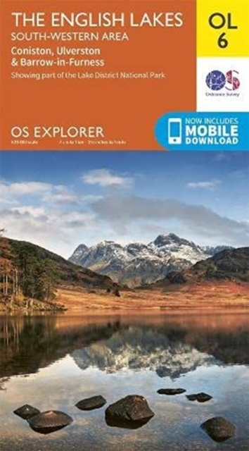
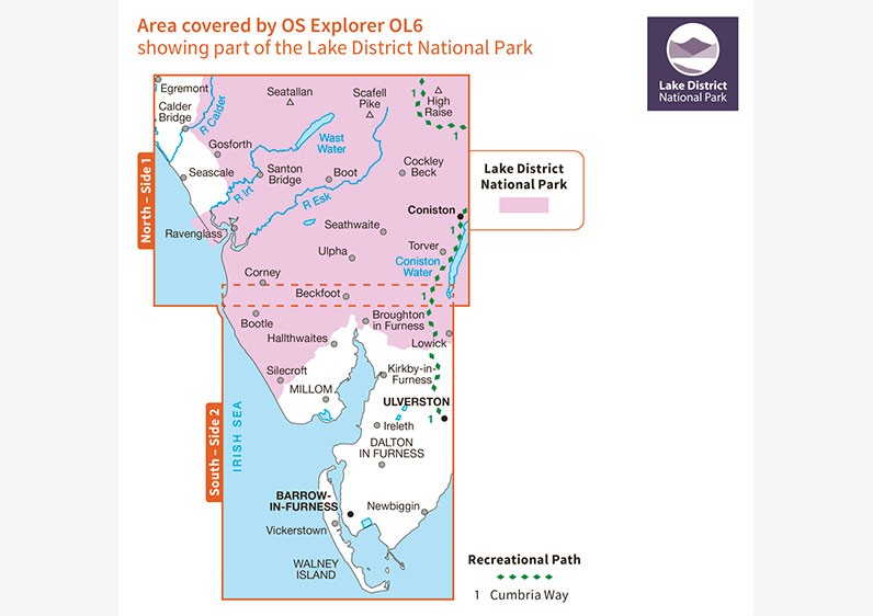
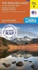
Wandelkaart - Topografische kaart OL06 OS Explorer Map English Lakes - South Western area | Ordnance Survey (9780319264010)
- ISBN / CODE: 9780319264010
- Editie: meest recente versie
- Schaal: 1:25000
- Uitgever: Ordnance Survey
- Soort: Topografische kaart, Wandelkaart
- Serie: OS Explorer Map
- Taal: Engels
- Uitvoering: -
- Bindwijze: -
- Beoordeling: 5,0 ★★★★★ (2 reviews) Schrijf een review
-
€ 19,50
Op voorraad. Voor 17.00 uur op werkdagen besteld, morgen in huis in Nederland Levertijd Belgie
Gratis verzending in Nederland vanaf €35,-

-
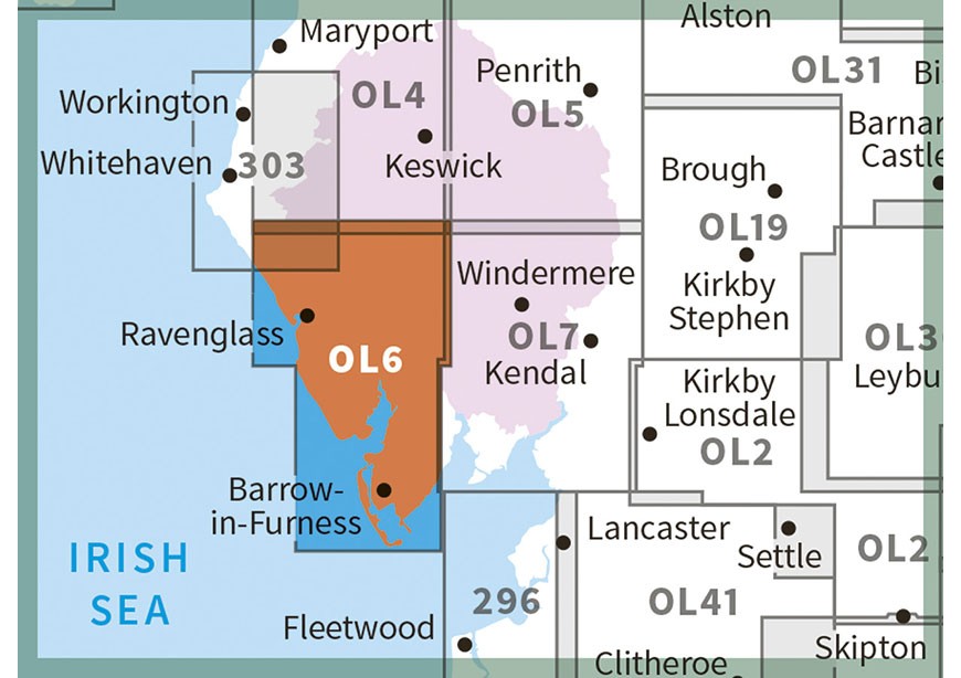
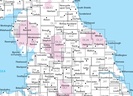
Overzichtskaart Explorer 25.000 topografische kaarten Noord Engeland - Lake District

Producten op deze overzichtskaart:
Klik op een product om naar de pagina van dat product te gaan.
- Wandelkaart - Topografische kaart 275 OS Explorer Map Liverpool St Helens, Widnes & Runcorn | Ordnance Survey
- Wandelkaart - Topografische kaart 276 OS Explorer Map Bolton Central, Wigan & Warrington | Ordnance Survey
- Wandelkaart - Topografische kaart 277 OS Explorer Map Manchester & Salford | Ordnance Survey
- Wandelkaart - Topografische kaart 278 OS Explorer Map Sheffield & Barnsley | Ordnance Survey
- Wandelkaart - Topografische kaart 279 OS Explorer Map Doncaster | Ordnance Survey
- Wandelkaart - Topografische kaart 280 OS Explorer Map Isle of Axholme | Ordnance Survey
- Wandelkaart - Topografische kaart 281 OS Explorer Map Ancholme Valley | Ordnance Survey
- Wandelkaart - Topografische kaart 282 OS Explorer Map Lincolnshire Wolds North | Ordnance Survey
- Wandelkaart - Topografische kaart 283 OS Explorer Map Louth, Mablethorpe | Ordnance Survey
- Wandelkaart - Topografische kaart 284 OS Explorer Map Grimsby, Cleethorpes, Immingham | Ordnance Survey
- Wandelkaart - Topografische kaart 285 OS Explorer Map Southport, Chorley | Ordnance Survey
- Wandelkaart - Topografische kaart 286 OS Explorer Map Blackpool, Preston | Ordnance Survey
- Wandelkaart - Topografische kaart 287 OS Explorer Map West Pennine Moors | Ordnance Survey
- Wandelkaart - Topografische kaart 288 OS Explorer Map Bradford, Huddersfield | Ordnance Survey
- Wandelkaart - Topografische kaart 289 OS Explorer Map Leeds | Ordnance Survey
- Wandelkaart - Topografische kaart 290 OS Explorer Map York | Ordnance Survey
- Wandelkaart - Topografische kaart 291 OS Explorer Map Goole, Gilberdyke | Ordnance Survey
- Wandelkaart - Topografische kaart 292 OS Explorer Map Withernsea & Spurn Head | Ordnance Survey
- Wandelkaart - Topografische kaart 293 OS Explorer Map Kingston upon Hull, Beverley | Ordnance Survey
- Wandelkaart - Topografische kaart 294 OS Explorer Map Market Weighton, Yorkshire Wolds Central | Ordnance Survey
- Wandelkaart - Topografische kaart 295 OS Explorer Map Bridlington, Driffield, Hornsea | Ordnance Survey
- Wandelkaart - Topografische kaart 296 OS Explorer Map Lancaster, Morecambe, Fleetwood | Ordnance Survey
- Wandelkaart - Topografische kaart 297 OS Explorer Map Lower Wharfedale & Washburn Valley | Ordnance Survey
- Wandelkaart - Topografische kaart 298 OS Explorer Map Nidderdale | Ordnance Survey
- Wandelkaart - Topografische kaart 299 OS Explorer Map Ripon, Boroughbridge | Ordnance Survey
- Wandelkaart - Topografische kaart 300 OS Explorer Map Howardian Hills, Malton | Ordnance Survey
- Wandelkaart - Topografische kaart 301 OS Explorer Map Scarborough, Bridlington & Flamborough Head | Ordnance Survey
- Wandelkaart - Topografische kaart 302 OS Explorer Map Northallerton, Thirsk | Ordnance Survey
- Wandelkaart - Topografische kaart 303 OS Explorer Map Whitehaven, Workington | Ordnance Survey
- Wandelkaart - Topografische kaart 304 OS Explorer Map Darlington, Richmond | Ordnance Survey
- Wandelkaart - Topografische kaart 305 OS Explorer Map Bishop Auckland | Ordnance Survey
- Wandelkaart - Topografische kaart 306 OS Explorer Map Middlesbrough, Hartlepool | Ordnance Survey
- Wandelkaart - Topografische kaart 307 OS Explorer Map Consett, Derwent reservoir | Ordnance Survey
- Wandelkaart - Topografische kaart 308 OS Explorer Map Durham, Sunderland | Ordnance Survey
- Wandelkaart - Topografische kaart 314 OS Explorer Map Solway Firth, Wigton, Silloth explorer | Ordnance Survey
- Wandelkaart - Topografische kaart 315 OS Explorer Map Carlisle, Brampton, Longtown, Gretna Green | Ordnance Survey
- Wandelkaart - Topografische kaart 316 OS Explorer Map Newcastle upon Tyne | Ordnance Survey
- Wandelkaart - Topografische kaart OL01 OS Explorer Map The Peak District - Dark Peak Area | Ordnance Survey
- Wandelkaart - Topografische kaart OL02 OS Explorer Map Yorkshire Dales - Southern & Western Area | Ordnance Survey
- Wandelkaart - Topografische kaart OL04 OS Explorer Map The English Lakes - North Western area | Ordnance Survey
- Wandelkaart - Topografische kaart OL05 OS Explorer Map The English Lakes - North Eastern area | Ordnance Survey
- Wandelkaart - Topografische kaart OL06 OS Explorer Map English Lakes - South Western area | Ordnance Survey
- Wandelkaart - Topografische kaart OL07 OS Explorer Map English Lakes - South Eastern area | Ordnance Survey
- Wandelkaart - Topografische kaart OL19 OS Explorer Map Howgill Fells and Upper Eden Valley | Ordnance Survey
- Wandelkaart - Topografische kaart OL21 OS Explorer Map South Pennines | Ordnance Survey
- Wandelkaart - Topografische kaart OL26 OS Explorer Map North York Moors - Western area | Ordnance Survey
- Wandelkaart - Topografische kaart OL27 OS Explorer Map North York Moors - Eastern area | Ordnance Survey
- Wandelkaart - Topografische kaart OL30 OS Explorer Map Yorkshire Dales - Northern & Central Area | Ordnance Survey
- Wandelkaart - Topografische kaart OL31 OS Explorer Map North Pennines | Ordnance Survey
- Wandelkaart - Topografische kaart OL41 OS Explorer Map Forest of Bowland - Ribblesdale | Ordnance Survey
- Wandelkaart - Topografische kaart OL43 OS Explorer Map Hadrian's Wall | Ordnance Survey
-
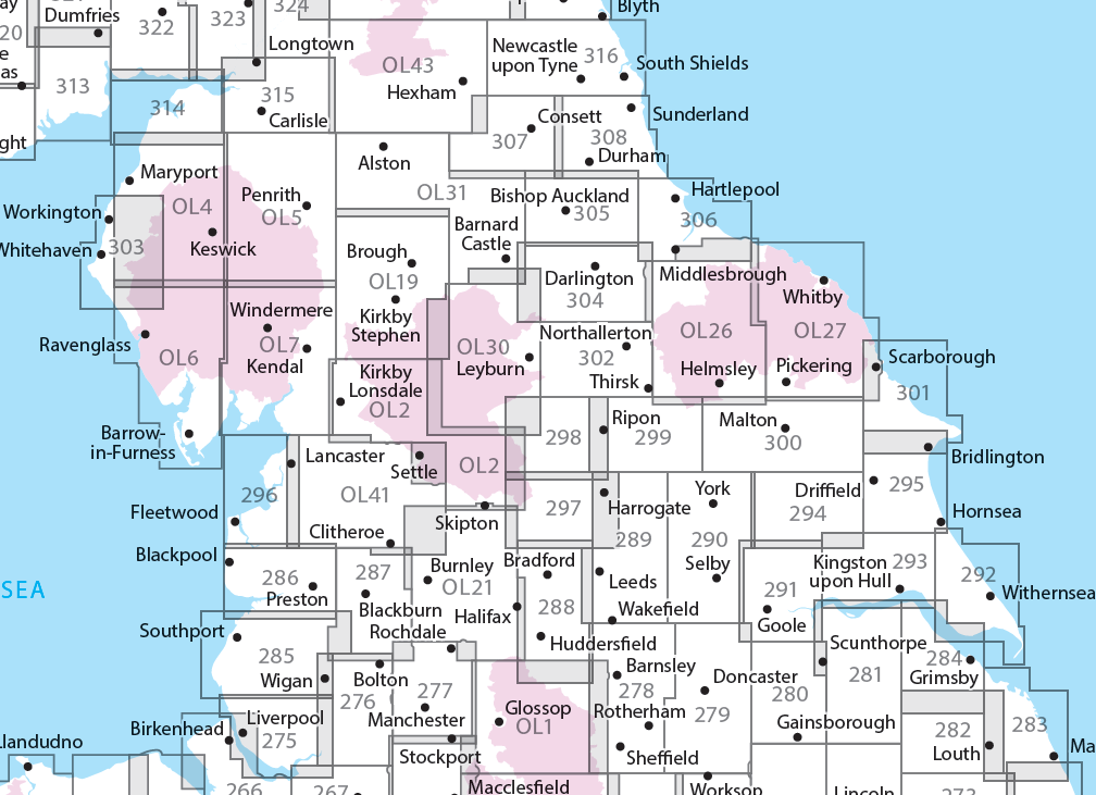
Overzichtskaart Explorer 25.000 wandelkaarten Noord Engeland - Lake District

Producten op deze overzichtskaart:
Klik op een product om naar de pagina van dat product te gaan.
- Wandelkaart - Topografische kaart 275 OS Explorer Map Liverpool St Helens, Widnes & Runcorn | Ordnance Survey
- Wandelkaart - Topografische kaart 276 OS Explorer Map Bolton Central, Wigan & Warrington | Ordnance Survey
- Wandelkaart - Topografische kaart 277 OS Explorer Map Manchester & Salford | Ordnance Survey
- Wandelkaart - Topografische kaart 278 OS Explorer Map Sheffield & Barnsley | Ordnance Survey
- Wandelkaart - Topografische kaart 279 OS Explorer Map Doncaster | Ordnance Survey
- Wandelkaart - Topografische kaart 280 OS Explorer Map Isle of Axholme | Ordnance Survey
- Wandelkaart - Topografische kaart 281 OS Explorer Map Ancholme Valley | Ordnance Survey
- Wandelkaart - Topografische kaart 282 OS Explorer Map Lincolnshire Wolds North | Ordnance Survey
- Wandelkaart - Topografische kaart 283 OS Explorer Map Louth, Mablethorpe | Ordnance Survey
- Wandelkaart - Topografische kaart 284 OS Explorer Map Grimsby, Cleethorpes, Immingham | Ordnance Survey
- Wandelkaart - Topografische kaart 285 OS Explorer Map Southport, Chorley | Ordnance Survey
- Wandelkaart - Topografische kaart 286 OS Explorer Map Blackpool, Preston | Ordnance Survey
- Wandelkaart - Topografische kaart 287 OS Explorer Map West Pennine Moors | Ordnance Survey
- Wandelkaart - Topografische kaart 288 OS Explorer Map Bradford, Huddersfield | Ordnance Survey
- Wandelkaart - Topografische kaart 289 OS Explorer Map Leeds | Ordnance Survey
- Wandelkaart - Topografische kaart 290 OS Explorer Map York | Ordnance Survey
- Wandelkaart - Topografische kaart 291 OS Explorer Map Goole, Gilberdyke | Ordnance Survey
- Wandelkaart - Topografische kaart 292 OS Explorer Map Withernsea & Spurn Head | Ordnance Survey
- Wandelkaart - Topografische kaart 293 OS Explorer Map Kingston upon Hull, Beverley | Ordnance Survey
- Wandelkaart - Topografische kaart 294 OS Explorer Map Market Weighton, Yorkshire Wolds Central | Ordnance Survey
- Wandelkaart - Topografische kaart 295 OS Explorer Map Bridlington, Driffield, Hornsea | Ordnance Survey
- Wandelkaart - Topografische kaart 296 OS Explorer Map Lancaster, Morecambe, Fleetwood | Ordnance Survey
- Wandelkaart - Topografische kaart 297 OS Explorer Map Lower Wharfedale & Washburn Valley | Ordnance Survey
- Wandelkaart - Topografische kaart 298 OS Explorer Map Nidderdale | Ordnance Survey
- Wandelkaart - Topografische kaart 299 OS Explorer Map Ripon, Boroughbridge | Ordnance Survey
- Wandelkaart - Topografische kaart 300 OS Explorer Map Howardian Hills, Malton | Ordnance Survey
- Wandelkaart - Topografische kaart 301 OS Explorer Map Scarborough, Bridlington & Flamborough Head | Ordnance Survey
- Wandelkaart - Topografische kaart 302 OS Explorer Map Northallerton, Thirsk | Ordnance Survey
- Wandelkaart - Topografische kaart 303 OS Explorer Map Whitehaven, Workington | Ordnance Survey
- Wandelkaart - Topografische kaart 304 OS Explorer Map Darlington, Richmond | Ordnance Survey
- Wandelkaart - Topografische kaart 305 OS Explorer Map Bishop Auckland | Ordnance Survey
- Wandelkaart - Topografische kaart 306 OS Explorer Map Middlesbrough, Hartlepool | Ordnance Survey
- Wandelkaart - Topografische kaart 307 OS Explorer Map Consett, Derwent reservoir | Ordnance Survey
- Wandelkaart - Topografische kaart 308 OS Explorer Map Durham, Sunderland | Ordnance Survey
- Wandelkaart - Topografische kaart 314 OS Explorer Map Solway Firth, Wigton, Silloth explorer | Ordnance Survey
- Wandelkaart - Topografische kaart 315 OS Explorer Map Carlisle, Brampton, Longtown, Gretna Green | Ordnance Survey
- Wandelkaart - Topografische kaart 316 OS Explorer Map Newcastle upon Tyne | Ordnance Survey
- Wandelkaart - Topografische kaart OL01 OS Explorer Map The Peak District - Dark Peak Area | Ordnance Survey
- Wandelkaart - Topografische kaart OL02 OS Explorer Map Yorkshire Dales - Southern & Western Area | Ordnance Survey
- Wandelkaart - Topografische kaart OL04 OS Explorer Map The English Lakes - North Western area | Ordnance Survey
- Wandelkaart - Topografische kaart OL05 OS Explorer Map The English Lakes - North Eastern area | Ordnance Survey
- Wandelkaart - Topografische kaart OL06 OS Explorer Map English Lakes - South Western area | Ordnance Survey
- Wandelkaart - Topografische kaart OL07 OS Explorer Map English Lakes - South Eastern area | Ordnance Survey
- Wandelkaart - Topografische kaart OL19 OS Explorer Map Howgill Fells and Upper Eden Valley | Ordnance Survey
- Wandelkaart - Topografische kaart OL21 OS Explorer Map South Pennines | Ordnance Survey
- Wandelkaart - Topografische kaart OL26 OS Explorer Map North York Moors - Western area | Ordnance Survey
- Wandelkaart - Topografische kaart OL27 OS Explorer Map North York Moors - Eastern area | Ordnance Survey
- Wandelkaart - Topografische kaart OL30 OS Explorer Map Yorkshire Dales - Northern & Central Area | Ordnance Survey
- Wandelkaart - Topografische kaart OL31 OS Explorer Map North Pennines | Ordnance Survey
- Wandelkaart - Topografische kaart OL41 OS Explorer Map Forest of Bowland - Ribblesdale | Ordnance Survey
- Wandelkaart - Topografische kaart OL43 OS Explorer Map Hadrian's Wall | Ordnance Survey
Overzichtskaarten
Beschrijving
Een van de beste detailkaarten die er op de wereld gemaakt worden: zeer gedetailleerd, prachtig helder kleurgebruik, veel topografische aspecten en - zeer belangrijk - allerlei toeristische en recreatieve aspecten zijn ingetekend. De perfecte kaart voor vakantie en vrije tijd: wandelen, fietsen of gewoon de omgeving verkennen. Door de grootte van de kaart, voor- en achterzijde, bestrijkt het een behoorlijk groot gebied!
These highly detailed maps show all the administrative boundaries, settlements as small as isolated farms, road network down to unfenced roads and country tracks, and field boundaries (hedges and drystone walls) which make navigation across the countryside much easier. Steep gradients on roads are indicated. Various landmarks, eg. powerlines, archaeological sites, windmills, churches and lighthouses are shown, and additional graphics indicate natural terrain features such as cliffs, scree, mud and vegetation variations. Contour interval is 5 metres in the lower parts of the country and 10 metres in the uplands, and spot heights are marked. Each map covers an area of 30 x 20km (i.e. approx. 19 x 12 miles), with some double-sided maps covering more, as indicated in the individual descriptions. The maps are fully GPS compatible, with the National Grid shown at 1km intervals and latitude and longitude indicated by margin ticks at 1'.
Explorer maps show a large amount of information for ramblers and tourists. Public rights of way are shown (except in Scotland), together with other routes with public access: National Trails and Recreational Paths, permitted paths and bridleways, and selected cycle routes. Open access land created under the Countryside and Rights of Way Act 2000 is marked. Tourist information includes caravan and camp sites, Park & Ride locations, recreation/leisure/sport centres, museums, historic buildings, English Heritage and National Trust sites, rural pubs, etc. The map legend is in English only, except for the tourist information content which is also in French and German.
Dit product heeft meerdere varianten:
Reviews
prima kaart om te wandelen
★★★★★ door Martin de Leeuw 20 juli 2012Vond u dit een nuttige review? (login om te beoordelen)
Uitstekende wandelkaart, de beste!
★★★★★ door Karin Willemsen 23 mei 2011Vond u dit een nuttige review? (login om te beoordelen)
Schrijf een review
Graag horen wij wat u van dit artikel vindt. Vindt u het goed, leuk, mooi, slecht, lelijk, onbruikbaar of erg handig: schrijf gerust alles op! Het is niet alleen leuk om te doen maar u informeert andere klanten er ook nog mee!
Ook interessant voor europa/engeland/north-west-england
-

Fietsgids Lost Lanes North | Wild Th
€ 23,95Fietsgidsen North East England -

Fietskaart 03 Tour Map Lake District
€ 10,95Fietskaarten North West England -

Wandelgids Walking in the North Penn
€ 19,95Wandelgidsen North West England -

Wandelkaart - Topografische kaart OL
€ 19,50Topografische kaarten North West England -

Reisgids Walks Lake District | Wild
€ 20,95Reisgidsen ♦ Cumbria
Contactgegevens
T: +31 (0)50 - 3 12 69 50
E: info@dezwerver.nl
![]()
![]()
![]()
![]()
![]()
Bankgegevens
IBAN: NL11 RABO 0140 1961 88
BIC: RABONL2U
Kamer van Koophandel
Kvk: 75240440
BTW-nummer
NL 860203633 B01
BE 0541 545 456
Openingstijden
- Maandag13.00 - 18.00
- Dinsdag10.00 - 18.00
- Woensdag10.00 - 18.00
-
Donderdag10.00 - 18.00
(donderdagavond gesloten) - Vrijdag10.00 - 18.00
- Zaterdag10.00 - 17.00
- Zondaggesloten
Nieuwsbrief
Op de hoogte blijven van nieuwe reisgidsen, travelgadgets en kaarten? Geef u op voor onze nieuwsbrief. U ontvangt de nieuwsbrief 1x per maand.
Bekijk hier onze laatste nieuwsbrief:
Onze laatste Nieuwsbrief