Topografische kaart - Wandelkaart 01 Discovery Donegal (NW) | Ordnance Survey Ireland (9781912140206)
- ISBN / CODE: 9781912140206
- Editie: meest recente versie
- Schaal: 1:50000
- Uitgever: Ordnance Survey Ireland
- Soort: Topografische kaart, Wandelkaart
- Serie: Discovery
- Taal: Engels
- Bindwijze: -
- Uitvoering: Papier
- Schrijf als eerste een review
-
€ 19,50
Op voorraad. Voor 17.00 uur op werkdagen besteld, morgen in huis in Nederland Levertijd Belgie
Gratis verzending in Nederland vanaf €35,-
-
Overzicht OS wandelkaarten Ierland
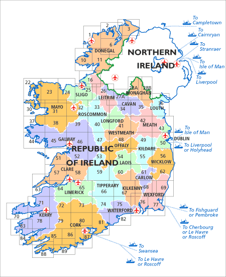
Producten op deze overzichtskaart:
Klik op een product om naar de pagina van dat product te gaan.
- Topografische kaart - Wandelkaart 01 Discovery Donegal (NW) | Ordnance Survey Ireland
- Topografische kaart - Wandelkaart 02 Discovery Donegal (N Centr) | Ordnance Survey Ireland
- Topografische kaart - Wandelkaart 03 Discovery Donegal (NE), Derry | Ordnance Survey Ireland
- Topografische kaart - Wandelkaart 06 Discovery Donegal (CENT), Tyrone | Ordnance Survey Ireland
- Topografische kaart - Wandelkaart 10 Discovery Donegal (SW) | Ordnance Survey Ireland
- Topografische kaart - Wandelkaart 11 Discovery Donegal (S) | Ordnance Survey Ireland
- Topografische kaart - Wandelkaart 16 Discovery Donegal, Fermanagh, Leitrim, Sligo | Ordnance Survey Ireland
- Topografische kaart - Wandelkaart 22 Discovery Mayo | Ordnance Survey Ireland
- Topografische kaart - Wandelkaart 23 Discovery Mayo | Ordnance Survey Ireland
- Topografische kaart - Wandelkaart 24 Discovery Mayo, Sligo | Ordnance Survey Ireland
- Topografische kaart - Wandelkaart 25 Discovery Sligo, Leitrim, Roscommon | Ordnance Survey Ireland
- Wandelkaart 26 Discoverer Lough Allen | Ordnance Survey Northern Ireland
- Topografische kaart - Wandelkaart 30 Discovery Ierland Mayo (W CENT) | Ordnance Survey Ireland
- Topografische kaart - Wandelkaart 31 Discovery Mayo (CENT) | Ordnance Survey Ireland
- Topografische kaart - Wandelkaart 32 Discovery Mayo, Roscommon, Sligo | Ordnance Survey Ireland
- Topografische kaart - Wandelkaart 33 Discovery Leitrim, Longford, Roscommon, Sligo | Ordnance Survey Ireland
- Topografische kaart - Wandelkaart 34 Discovery Cavan, Leitrim, Longford, Meath, Monaghan | Ordnance Survey Ireland
- Topografische kaart - Wandelkaart 35 Discovery Cavan, Louth, Meath, Monaghan | Ordnance Survey Ireland
- Topografische kaart - Wandelkaart 36 Discovery Armagh, Down, Louth, Meath, Monaghan | Ordnance Survey Ireland
- Topografische kaart - Wandelkaart 37 Discovery Mayo (SW), Galway | Ordnance Survey Ireland
- Topografische kaart - Wandelkaart 38 Discovery Galway, Mayo (S CENT) | Ordnance Survey Ireland
- Topografische kaart - Wandelkaart 39 Discovery Galway, Mayo, Roscommon | Ordnance Survey Ireland
- Topografische kaart - Wandelkaart 40 Discovery Galway, Longford, Roscommon, Westmeath | Ordnance Survey Ireland
- Topografische kaart - Wandelkaart 41 Discovery Longford, Meath, Westmeath | Ordnance Survey Ireland
- Topografische kaart - Wandelkaart 42 Discovery Meath, Westmeath | Ordnance Survey Ireland
- Topografische kaart - Wandelkaart 43 Discovery Dublin, Louth, Meath | Ordnance Survey Ireland
- Topografische kaart - Wandelkaart 44 Discovery Galway | Ordnance Survey Ireland
- Topografische kaart - Wandelkaart 45 Discovery Galway | Ordnance Survey Ireland
- Topografische kaart - Wandelkaart 46 Discovery Galway | Ordnance Survey Ireland
- Topografische kaart - Wandelkaart 47 Discovery Galway, Offaly, Roscommon, Westmeath | Ordnance Survey Ireland
- Topografische kaart - Wandelkaart 48 Discovery Offaly, Westmeath | Ordnance Survey Ireland
- Topografische kaart - Wandelkaart 49 Discovery Kildare, Meath, Offaly, Westmeath | Ordnance Survey Ireland
- Topografische kaart - Wandelkaart 50 Discovery Dublin, Kildare, Meath, Wicklow | Ordnance Survey Ireland
- Topografische kaart - Wandelkaart 51 Discovery Clare, Galway | Ordnance Survey Ireland
- Topografische kaart - Wandelkaart 52 Discovery Clare, Galway | Ordnance Survey Ireland
- Topografische kaart - Wandelkaart 53 Discovery Clare, Galway, Offaly, Tipperary | Ordnance Survey Ireland
- Topografische kaart - Wandelkaart 54 Discovery Laois, Offaly, Tipperary | Ordnance Survey Ireland
- Topografische kaart - Wandelkaart 55 Discovery Kildare, Laois, Offaly, Wicklow | Ordnance Survey Ireland
- Topografische kaart - Wandelkaart 56 Discovery Wicklow, Dublin, Kildare | Ordnance Survey Ireland
- Topografische kaart - Wandelkaart 57 Discovery Clare | Ordnance Survey Ireland
- Topografische kaart - Wandelkaart 58 Discovery Clare, Limerick, Tipperary | Ordnance Survey Ireland
- Topografische kaart - Wandelkaart 59 Discovery Clare, Offaly, Tipperary | Ordnance Survey Ireland
- Topografische kaart - Wandelkaart 60 Discovery Kilkenny, Laois, Tipperary | Ordnance Survey Ireland
- Topografische kaart - Wandelkaart 61 Discovery Carlow, Kildare, Kilkenny, Laois, Wicklow | Ordnance Survey Ireland
- Topografische kaart - Wandelkaart 62 Discovery Carlow, Wexford, Wicklow | Ordnance Survey Ireland
- Topografische kaart - Wandelkaart 63 Discovery Clare, Kerry | Ordnance Survey Ireland
- Topografische kaart - Wandelkaart 64 Discovery Clare, Kerry, Limerick | Ordnance Survey Ireland
- Topografische kaart - Wandelkaart 65 Discovery Clare, Limerick, Tipperary | Ordnance Survey Ireland
- Topografische kaart - Wandelkaart 66 Discovery Tipperary, Limerick | Ordnance Survey Ireland
- Topografische kaart - Wandelkaart 67 Discovery Kilkenny, Tipperary | Ordnance Survey Ireland
- Topografische kaart - Wandelkaart 68 Discovery Carlow, Kilkenny, Wexford | Ordnance Survey Ireland
- Topografische kaart - Wandelkaart 69 Discovery Wexford | Ordnance Survey Ireland
- Topografische kaart - Wandelkaart 70 Discovery Kerry | Ordnance Survey Ireland
- Topografische kaart - Wandelkaart 71 Discovery Kerry | Ordnance Survey Ireland
- Topografische kaart - Wandelkaart 72 Discovery Kerry, Cork, Limerick | Ordnance Survey Ireland
- Topografische kaart - Wandelkaart 73 Discovery Ierland discovery map Cork, Limerick | Ordnance Survey Ireland
- Topografische kaart - Wandelkaart 74 Discovery Cork, Limerick, Tipperary, Waterford | Ordnance Survey Ireland
- Topografische kaart - Wandelkaart 75 Discovery Kilkenny, Tipperary, Waterford (NORTH) | Ordnance Survey Ireland
- Topografische kaart - Wandelkaart 76 Discovery Carlow, Kilkenny, Waterford, Wexford | Ordnance Survey Ireland
- Topografische kaart - Wandelkaart 77 Discovery Wexford | Ordnance Survey Ireland
- Topografische kaart - Wandelkaart 78 Discovery Kerry | Ordnance Survey Ireland
- Topografische kaart - Wandelkaart 79 Discovery Cork, Kerry | Ordnance Survey Ireland
- Topografische kaart - Wandelkaart 80 Discovery Cork | Ordnance Survey Ireland
- Topografische kaart - Wandelkaart 81 Discovery Cork, Waterford | Ordnance Survey Ireland
- Topografische kaart - Wandelkaart 82 Discovery Waterford | Ordnance Survey Ireland
- Topografische kaart - Wandelkaart 83 Discovery Kerry (Caherciveen) | Ordnance Survey Ireland
- Topografische kaart - Wandelkaart 84 Discovery Cork, Kerry | Ordnance Survey Ireland
- Topografische kaart - Wandelkaart 85 Discovery Cork (Bantry) , Kerry | Ordnance Survey Ireland
- Topografische kaart - Wandelkaart 86 Discovery Cork (Bandon) | Ordnance Survey Ireland
- Topografische kaart - Wandelkaart 87 Discovery Cork (Kinsale) | Ordnance Survey Ireland
- Topografische kaart - Wandelkaart 88 Discovery Cork (Dunmanus Bay) | Ordnance Survey Ireland
- Topografische kaart - Wandelkaart 89 Discovery Cork (Skibbereen) | Ordnance Survey Ireland
Overzichtskaarten
Beschrijving
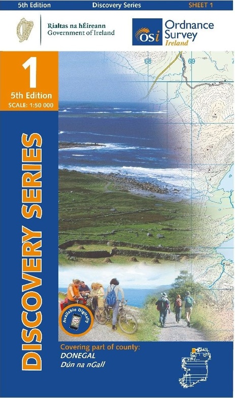
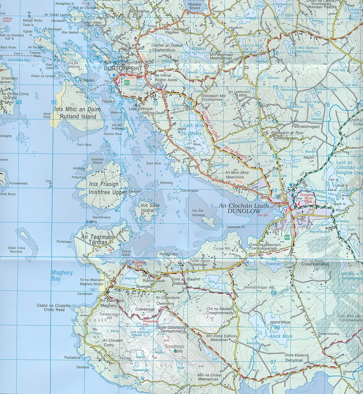
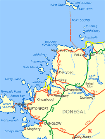
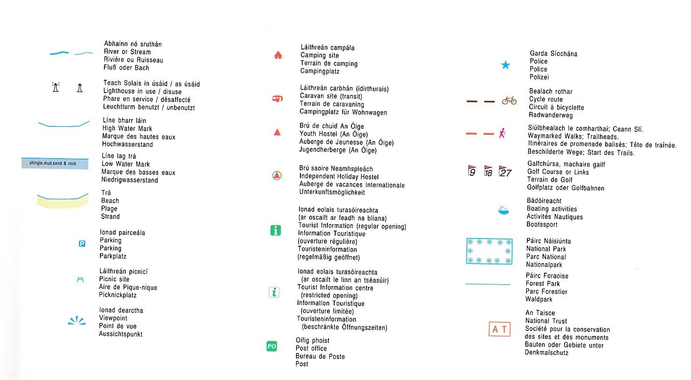
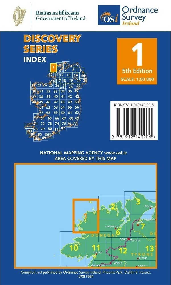
Zeer gedetailleerde topografische kaart met een aantal toegevoegde toeristische symbolen voor bijv. bezienswaardigheden, campings en jeugdherbergen. Met hoogtelijnen, mooi kleurgebruik en ingetekende lange-afstands-wandelroutes. Op deze kaart zijn de nationale parken en de 'national reserves ' uitstekend te vinden.
De kaart is dus zowel voor de geoefende kaartlezer als voor diegene die een kaart zoekt voor gewoon recreatief gebruik bijzonder handig. Met het 1km ITM grid en graden-indeling is de kaart geschikt voor gebruik met GPS. Per kaart uit deze serie wordt een gebied gedekt van ca. 40 x 30 kilometer.
De kaart is dan ook als wandelkaart Ierland te gebruiken, maar ook als topografische kaart Ierland.
Reviews
Geen reviews gevonden voor dit product.
Schrijf een review
Graag horen wij wat u van dit artikel vindt. Vindt u het goed, leuk, mooi, slecht, lelijk, onbruikbaar of erg handig: schrijf gerust alles op! Het is niet alleen leuk om te doen maar u informeert andere klanten er ook nog mee!
Ook interessant voor europa/ierland/donegal-mayo
-

Reisgids Ireland's Wild Atlantic Way
€ 24,95Reisgidsen Ierland -

Wegenatlas Ireland Comprehensive Roa
€ 14,95Wegenatlassen Ierland -

Wandelgids Irlands Westküste - Ierla
€ 15,50Wandelgidsen Cork - Kerry - Dingle - Zuidwest Ierland -

Campergids 29 Mit dem Wohnmobil nach
€ 23,95Campergidsen Ierland -
 | Ordnance Survey Ireland")
Topografische kaart - Wandelkaart 38
€ 19,50Topografische kaarten Donegal - Mayo - Noordwest Ierland