Superwalker XT25 maps
De ultieme kaarten voor wandelaars: ontdek de Super Walker XT25 Maps van Harvey Maps
 Wandelkaart Cairn Gorm | Harvey Maps
Includes 18 Munros of which 5 over 4000' (Cairn Gorm, Ben Macdui, Cairn Toul, Braeriach & Sgor an Loachain Uaine) and 3 Corbetts. Detailed map for hillwalkers of the …
 Wandelkaart Lake District West | Harvey Maps
 Wandelkaart Ochil Hills | Harvey Maps
Superwalker is designed to be the most practical tool for navigation outdoors. The format gives more mapping on the sheet without making the map heavy and bulky. The fold has …
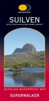 Wandelkaart Suilven / Stac Pollaidh & Ben More Assynt harve | Harvey Maps
Suilven covers the spectacular group of remote northerly munros popular with walkers and climbers. The map area includes Suilven, Canisp, CulMor,Breabag Stac Pollaidh, Conival & Ben More Assynt. This map …
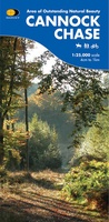 Wandelkaart Cannock Chase | Harvey Maps
New 1:25,000 scale map of this popular area in the West Midlands. Ideal for walking, mountain biking and other outdoor activities. Made with support from the Cannock Chase Area of …
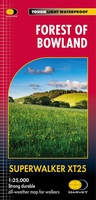 Wandelkaart Forest of Bowland XT25 | Harvey Maps
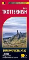 Wandelkaart Skye Trotternish | Harvey Maps
Een bijzonder handige kaart van dit gebied. Op waterafstotend papier met veel details. Detailed map for walking, scrambling and climbing The Trotternish Ridge from Portree north. This map for …
 Wandelkaart Glen Coe | Harvey Maps
Includes Buachaille Etive Mor, the Three Sisters of Glen Coe and Bidean nam Bian. Detailed map for hillwalkers of Glen Coe and the Aonach Eagach ridge at the popular …
 Wandelkaart Snowdonia Noord /Snowdon,Glyders,Carnedds | Harvey Maps
New Revised Edition and Format. More than a map, an essential piece of equipment this new generation HARVEY Superwalker is designed to be the most practical tool for navigation outdoors. …
 Wandelkaart Yorkshire Dales Noord-Oost | Harvey Maps
The Yorkshire Dales National Park on just 4 sheets. Yorkshire Dales North East: The coverage of this map includes Swaledale, Wharfedale, Wensleydale and Nidderdale. Genuine original HARVEY mapping at 1:25,000. …
 Wandelkaart Jura - Schotland | Harvey Maps
Shows the Paps of Jura and includes 1 Corbett and 2 Grahams. This detailed map for hillwalkers shows the whole of the Isle of Jura at the popular 1:25,000 …
 Wandelkaart Crieff & Comrie, Doune, Dunblane | Harvey Maps
Map covers the Munro, Ben Chonzie, popular Glen Artney, as well as the Braes of Doune and Doune Castle, which has featured in various film and television shows, such as …
 Wandelkaart Isle of Man | Harvey Maps
Een bijzonder handige kaart van dit gebied. Op waterafstotend papier met veel details. Includes long distance routes, rights of way and Public Ramblage. Detailed map for hillwalkers at 1:30,000 …
 Wandelkaart Dingle Peninsula | Harvey Maps
The whole of the Dingle Peninsula on one lightweight, waterproof map at the popular 1:30,000 scale. Includes Mount Brandon and the entire Brandon Group of mountains in the west …
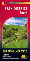 Wandelkaart Peak District South | Harvey Maps
Een bijzonder handige kaart van dit gebied. Op waterafstotend papier met veel details. Covers the area from Buxton to Matlock. Includes Leek, the Roaches and Dovedale. Detailed map for …
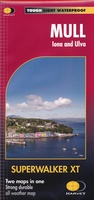 Wandelkaart Mull - Iona - Ulva | Harvey Maps
Zeer duidelijke kaart van Mull, met o.a. hoogtelijnen en geschikt voor gebruik met GPS.Two maps in one! 1:25,000 scale walking map of the mountains of Mull with a recreation …
 Wandelkaart Pentland Hills | Harvey Maps
The whole of the Pentlands on one side of one sheet. More than a map, an essential piece of equipment this new generation HARVEY Superwalker is designed to be the …
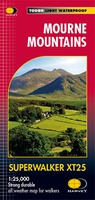 Wandelkaart Mourne Mountains | Harvey Maps
The Mournes, a granite mountain range in County Down, includes the highest mountains in Northern Ireland. The highest is Slieve Donard at 850 metres. Detailed map for hillwalkers of …
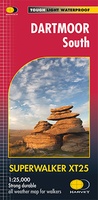 Wandelkaart Dartmoor Zuid | Harvey Maps
The whole of Dartmoor on two Maps. Dartmoor's famous Tors including Haytor Rocks and Yes Tor. The format gives more mapping on the sheet without making the map heavy and …
 Wandelkaart Wicklow Mountains | Harvey Maps
Zeer duidelijke kaart van de Wicklow Mountains in Ierland. Met o.a. hoogtelijnen en geschikt voor gebruik met GPS. HARVEY Superwalker map at 1:30,000 scale. Clear, easy to use, waterproof. GPS …
★★★★★
Laatste reviews

Op zich een goede kaart, maar het is eigenlijk gewoon een uitvergroting van de bekende 1:200.000-kaarten, dus weinig tot geen extra informatie. Wel wat duidelijker …
★★★★★ door FGM Ballhaus 13 mei 2026 | Heeft dit artikel gekocht
Duidelijke kaart, goed voor fietsen, iets minder voor wandelen door de schaal, maar er is heel weinig kaartmateriaal voor dit gebied dus daarom toch dik …
★★★★★ door FGM Ballhaus 13 mei 2026 | Heeft dit artikel gekocht
Fietskaart is een goede aanvulling op de Nederlandse fietskaarten, laat de Achterhoek zien maar ook een heel stuk Duitsland in (naar het oosten). Kwalitatief ook …
★★★★★ door FGM Ballhaus 13 mei 2026 | Heeft dit artikel gekocht
Keurig verpakt, snel verzonden. Boek voldoet aan mijn verwachtingen!
★★★★★ door Beatrice 12 mei 2026 | Heeft dit artikel gekocht