Winkelwagen
Geen items in winkelwagen
Ga naar winkelwagen
Topografische kaarten - Lanzarote
 Topografische kaart 1084 MT50 Playa Blanca (Lanzarote) | CNIG - Instituto Geográfico Nacional1
 Topografische kaart 1084-I/II Playa Blanca (Lanzarote) | CNIG - Instituto Geográfico Nacional
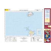 Topografische kaart 1079 MT50 Isla de Alegranza (Lanzarote) | CNIG - Instituto Geográfico Nacional1
 Topografische kaart 1079-II Isla de Alegranza (Lanzarote) | CNIG - Instituto Geográfico Nacional
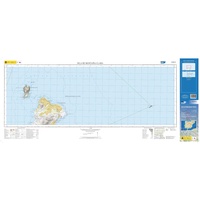 Topografische kaart 1079-IV Isla de Montaña Clara (Lanzarote) | CNIG - Instituto Geográfico Nacional
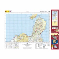 Topografische kaart 1080 MT50 Haría (Lanzarote) | CNIG - Instituto Geográfico Nacional1
 Topografische kaart 1080-II Caleta de Sebo (Lanzarote) | CNIG - Instituto Geográfico Nacional
 Topografische kaart 1080-III Soo (Lanzarote) | CNIG - Instituto Geográfico Nacional
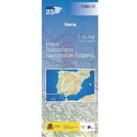 Topografische kaart 1080-IV Haría (Lanzarote) | CNIG - Instituto Geográfico Nacional
 Topografische kaart 1081 MT50 Yaiza (Lanzarote) | CNIG - Instituto Geográfico Nacional1
 Topografische kaart 1081-II Timanfaya (Lanzarote) | CNIG - Instituto Geográfico Nacional
 Topografische kaart 1081-IV Yaiza (Lanzarote) | CNIG - Instituto Geográfico Nacional
 Topografische kaart 1082 MT50 Arrecife (Lanzarote) | CNIG - Instituto Geográfico Nacional1
Laatste reviews

Prima fietskaart
Ik denk dat ik met deze fietskaart prima uit de voeten kan. Maar dat weet ik pas na de zomer.
★★★★★ door Prins 27 maart 2026 | Heeft dit artikel gekocht
handzame praktische kaart
Heel handige set routekaartjes, gemakkelijk in je jaszak te doen, weerbestendig, veel detailinformatie.
★★★★★ door Marco van Schaik 26 maart 2026 | Heeft dit artikel gekocht
Onweerstaanbaar die OS-kaarten
De topografische kaarten van Ordnance Survey (OS Explorer) op schaal 1:25.000 zijn altijd een genot om mee te werken. Geen detail mist. En dan ook …
★★★★★ door Bert ter Horst 26 maart 2026 | Heeft dit artikel gekocht
Vertrouwd en blijvend actueel
De wegenkaart van West Australie is zeer aan te bevelen.
★★★★★ door Henk 25 maart 2026 | Heeft dit artikel gekocht