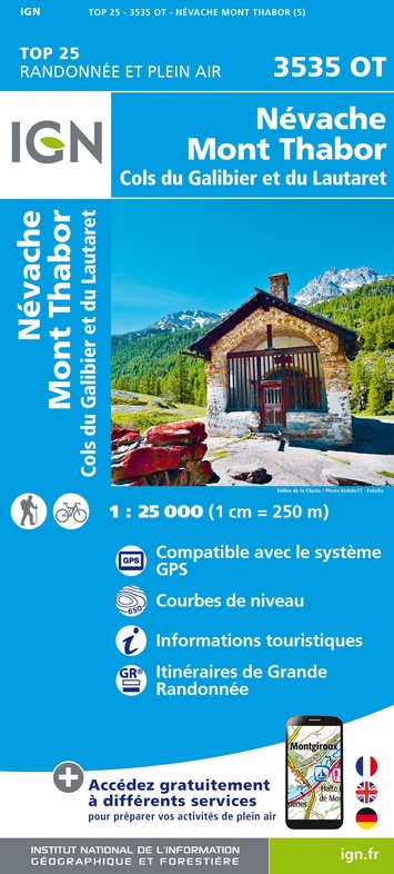
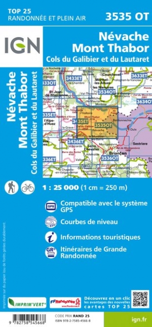
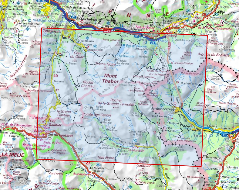
Wandelkaart - Topografische kaart 3535OT Névache - Mont Thabor | IGN - Institut Géographique National (9782758545668)
Cols du Galibier et du Lautaret
- ISBN / CODE: 9782758545668
- Editie: 08-10-2018
- Druk: 5
- Aantal blz.: 1
- Schaal: 1:25000
- Uitgever: IGN - Institut Géographique National
- Soort: Topografische kaart, Wandelkaart
- Serie: Top 25
- Taal: Frans
- Hoogte: 24.0 cm
- Breedte: 11.0 cm
- Gewicht: 98.0 g
- Uitvoering: Papier
- Bindwijze: -
- Beoordeling: 4,7 ★★★★★ ★★★★★ (9 reviews) Schrijf een review
-
€ 17,95
Uitverkocht, nooit meer leverbaar

.jpg)
-
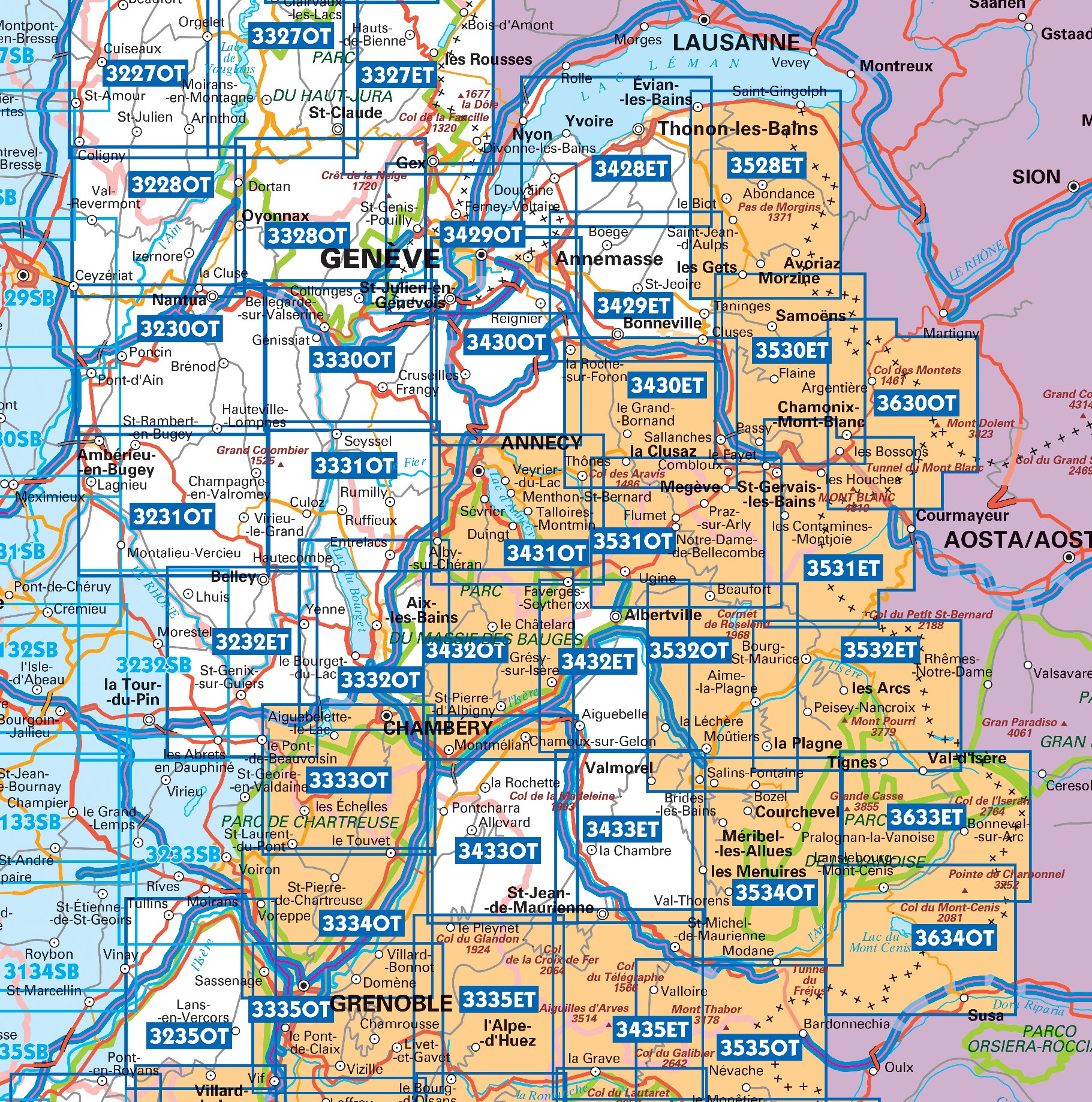
Topografische kaarten IGN 25.000 Savoie - Vanoise

Producten op deze overzichtskaart:
Klik op een product om naar de pagina van dat product te gaan.
- Wandelkaart - Topografische kaart 3333OT Massif de la Chartreuse Nord | IGN - Institut Géographique National
- Wandelkaart - Topografische kaart 3334OT Massif de la Chartreuse Sud | IGN - Institut Géographique National
- Wandelkaart - Topografische kaart 3335ET le Bourg d'Oisans - l'Alpe d'Huez | IGN - Institut Géographique National
- Wandelkaart - Topografische kaart 3335OT Grenoble | IGN - Institut Géographique National
- Wandelkaart - Topografische kaart 3335OTR Grenoble | IGN - Institut Géographique National
- Wandelkaart - Topografische kaart 3432ET Albertville | IGN - Institut Géographique National
- Wandelkaart - Topografische kaart 3432OT Massif des Bauges | IGN - Institut Géographique National
- Wandelkaart - Topografische kaart 3432OTR Massif des Bauges | IGN - Institut Géographique National
- Wandelkaart - Topografische kaart 3433ET Saint-Jean-de-Maurienne | IGN - Institut Géographique National
- Wandelkaart - Topografische kaart 3433OT Allevard | IGN - Institut Géographique National
- Wandelkaart - Topografische kaart 3532OT Massif du Beaufortain | IGN - Institut Géographique National
-
Wandelkaarten IGN 25.000 Savoie - Vanoise

Producten op deze overzichtskaart:
Klik op een product om naar de pagina van dat product te gaan.
- Wandelkaart 3233 SB - Serie Bleue Voiron / Tullins | IGN - Institut Géographique National
- Wandelkaart - Topografische kaart 3333OT Massif de la Chartreuse Nord | IGN - Institut Géographique National
- Wandelkaart - Topografische kaart 3334OT Massif de la Chartreuse Sud | IGN - Institut Géographique National
- Wandelkaart - Topografische kaart 3335ET le Bourg d'Oisans - l'Alpe d'Huez | IGN - Institut Géographique National
- Wandelkaart - Topografische kaart 3335OT Grenoble | IGN - Institut Géographique National
- Wandelkaart - Topografische kaart 3335OTR Grenoble | IGN - Institut Géographique National
- Wandelkaart - Topografische kaart 3432ET Albertville | IGN - Institut Géographique National
- Wandelkaart - Topografische kaart 3432OT Massif des Bauges | IGN - Institut Géographique National
- Wandelkaart - Topografische kaart 3432OTR Massif des Bauges | IGN - Institut Géographique National
- Wandelkaart - Topografische kaart 3433ET Saint-Jean-de-Maurienne | IGN - Institut Géographique National
- Wandelkaart - Topografische kaart 3433OT Allevard | IGN - Institut Géographique National
- Wandelkaart 3435ET Valloire / Aiguilles d'Arves / Col du Galibier | IGN - Institut Géographique National
- Wandelkaart - Topografische kaart 3532OT Massif du Beaufortain | IGN - Institut Géographique National
- Wandelkaart 3534OT Les Trois Vallées | IGN - Institut Géographique National
- Wegenkaart - landkaart 3535OT Névache - Mont Thabor | IGN - Institut Géographique National
- Wandelkaart 3633ET Tignes - Val d'Isère | IGN - Institut Géographique National
- Wandelkaart 3634OT Val Cenis | IGN - Institut Géographique National
Overzichtskaarten
Beschrijving
Reviews
Fijn mee gewandeld.
★★★★★ door K. Knechten 30 juli 2024 | Heeft dit artikel gekochtVond u dit een nuttige review? (login om te beoordelen)
Geeft een goed en gedetailleerd overzicht van de omgeving, wandelpaden en plekken om te overnachten. Veel aan gehad tijdens het wandelen van de GR57/Tour du Mont Thabor!
★★★★★ door Renee 17 augustus 2023 | Heeft dit artikel gekochtVond u dit een nuttige review? (login om te beoordelen)
Gedetailleerde wandelkaart, noodzakelijk bij bergwandelingen. Sommige minder druk belopen paden staan er niet op.
★★★★★ door Marco van Schaik 10 september 2021 | Heeft dit artikel gekochtVond u dit een nuttige review? (login om te beoordelen)
Schrijf een review
Graag horen wij wat u van dit artikel vindt. Vindt u het goed, leuk, mooi, slecht, lelijk, onbruikbaar of erg handig: schrijf gerust alles op! Het is niet alleen leuk om te doen maar u informeert andere klanten er ook nog mee!
Ook interessant voor europa/frankrijk/provence-alpes-cote-dazur/hautes-alpes
-

Wandelgids 0508 Tour de l'Oisans & d
€ 20,95Wandelgidsen Isère -

Wandelkaart - Topografische kaart 33
€ 17,95Topografische kaarten Alpes-de-Haute-Provence -

Klimgids - Klettersteiggids Chamonix
€ 25,95Klimgids - Klettersteiggidsen Haute-Savoie -

Wegenkaart - landkaart 3336ET Les De
€ 17,95Wegenkaarten Isère -

Wandelgids 0738 La Haute Traversée d
€ 20,95Wandelgidsen Isère