Topografische kaarten - Frankrijk
De kaarten van IGN (kort voor Institute Geographique National), wandelkaarten voor Frankrijk, zijn van een ongekend hoog niveau. Met name de wandelkaarten 1:25.000 vinden wij geweldig: werkelijk alles staat erop, de kaarten bevatten zeer veel details en het kleurgebruik is fantastisch, waardoor alles ook nog eens heel goed leesbaar. Je hoort het: wij zijn fan van deze kaarten!
 Wandelkaart - Topografische kaart 0419ET Audierne, Pointe du Raz, Pont-Croix,Plouhinec, Plozévet | IGN - Institut Géographique National
 Topografische kaart - Wandelkaart 0515ET St-Pol-de-Léon | IGN - Institut Géographique National
 Wandelkaart - Topografische kaart 0517OT Plougastel, Daoulas, Le Faou, PNR D'Armorique | IGN - Institut Géographique National
 Wandelkaart - Topografische kaart 0518OT Chateaulin, Douarnenez, Locronan, Ménez Hom, Le Faou | IGN - Institut Géographique National
 Wandelkaart - Topografische kaart 0519ET Quimper, Concarneau, Fouesnant, Beg-Meil, iles de Glénan | IGN - Institut Géographique National
 Wandelkaart - Topografische kaart 0519OT Pont l Abbé, Pointe de Penmarc h, Plogastel-St.-Germain, Plonéour-Lanvern | IGN - Institut Géographique National★★★★★
 Wandelkaart - Topografische kaart 0615ET Morlaix, Lanmeur, Plougasnou, Taule, Plestin-les-Greves | IGN - Institut Géographique National★★★★★
 Wandelkaart - Topografische kaart 0620ET Quimperlé, Pont-Aven, Tregunc, Bannalec, Clohars-Carnoët | IGN - Institut Géographique National★★★★★
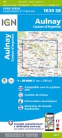 Wandelkaart - Topografische kaart 1630 SB - Serie Bleue Aulnay | IGN - Institut Géographique National
 Wandelkaart - Topografische kaart 1631 SB - Serie Bleue Matha | IGN - Institut Géographique National
 Wandelkaart - Topografische kaart 1632 SB - Serie Bleue Cognac | IGN - Institut Géographique National
 Wandelkaart - Topografische kaart 1633 SB - Serie Bleue Barbezieux-Saint-Hilaire | IGN - Institut Géographique National
 Wandelkaart - Topografische kaart 1634 SB - Serie Bleue Brossac - Montguyon | IGN - Institut Géographique National
 Wandelkaart - Topografische kaart 1635 SB - Serie Bleue Guîtres - Coutras | IGN - Institut Géographique National
 Wandelkaart - Topografische kaart 1636 SB - Serie Bleue Libourne, Saint-Emilion | IGN - Institut Géographique National★★★★★
 Wandelkaart - Topografische kaart 1637 SB - Serie Bleue Podensac | IGN - Institut Géographique National
 Topografische kaart - Wandelkaart 1638 La Réole - Langon | IGN - Institut Géographique National
 Wandelkaart - Topografische kaart 1639 SB - Serie Bleue Grignols - Bazas | IGN - Institut Géographique National
 Wandelkaart - Topografische kaart 1640 SB - Serie Bleue Losse | IGN - Institut Géographique National
 Wandelkaart - Topografische kaart 1641 SB - Serie Bleue Roquefort | IGN - Institut Géographique National
Laatste reviews

De bestelling snel en netjes afgehandeld
★★★★★ door Tiny Waltmans 03 april 2026 | Heeft dit artikel gekocht
Ik ben dol op de veldkaarten over verschillende vogelsoorten, per land of werelddelen. Deze keer de kaart besteld over vogelsoorten in Afrika en tijdens mijn …
★★★★★ door Kelly Bosch 02 april 2026 | Heeft dit artikel gekocht
Precies wat ik zocht. De informatie op de website was duidelijk en klopte. Het was eerst niet leverbaar, maar ik had aangegeven dat ik bericht …
★★★★★ door Mieke van den Broek 01 april 2026 | Heeft dit artikel gekocht
Snelle levering, prima verpakt, en de atlas van Duitsland is precies wat ik had verwacht, heel erg goed.
★★★★★ door Wil Van der Vlist 01 april 2026 | Heeft dit artikel gekocht