Winkelwagen
Geen items in winkelwagen
Ga naar winkelwagen
Topografische kaarten - Frankrijk
De kaarten van IGN (kort voor Institute Geographique National), wandelkaarten voor Frankrijk, zijn van een ongekend hoog niveau. Met name de wandelkaarten 1:25.000 vinden wij geweldig: werkelijk alles staat erop, de kaarten bevatten zeer veel details en het kleurgebruik is fantastisch, waardoor alles ook nog eens heel goed leesbaar. Je hoort het: wij zijn fan van deze kaarten!
 Wandelkaart - Topografische kaart 1628 SB - Serie Bleue St-Maixent-l'Ecole, Lezay | IGN - Institut Géographique National
 Wandelkaart - Topografische kaart 1629 Melle | IGN - Institut Géographique National
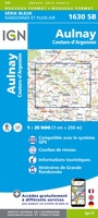 Wandelkaart - Topografische kaart 1630 SB - Serie Bleue Aulnay | IGN - Institut Géographique National
 Wandelkaart - Topografische kaart 1631 SB - Serie Bleue Matha | IGN - Institut Géographique National
 Wandelkaart - Topografische kaart 1632 SB - Serie Bleue Cognac | IGN - Institut Géographique National
 Wandelkaart - Topografische kaart 1633 SB - Serie Bleue Barbezieux-Saint-Hilaire | IGN - Institut Géographique National
 Wandelkaart - Topografische kaart 1634 SB - Serie Bleue Brossac - Montguyon | IGN - Institut Géographique National
 Wandelkaart - Topografische kaart 1635 SB - Serie Bleue Guîtres - Coutras | IGN - Institut Géographique National
 Wandelkaart - Topografische kaart 1636 SB - Serie Bleue Libourne, Saint-Emilion | IGN - Institut Géographique National★★★★★
 Wandelkaart - Topografische kaart 1637 SB - Serie Bleue Podensac | IGN - Institut Géographique National
 Topografische kaart - Wandelkaart 1638 La Réole - Langon | IGN - Institut Géographique National
 Wandelkaart - Topografische kaart 1639 SB - Serie Bleue Grignols - Bazas | IGN - Institut Géographique National
 Wandelkaart - Topografische kaart 1640 SB - Serie Bleue Losse | IGN - Institut Géographique National
 Wandelkaart - Topografische kaart 1641 SB - Serie Bleue Roquefort | IGN - Institut Géographique National
 Wandelkaart - Topografische kaart 1642 SB - Serie Bleue Villeneuve-de-Marsan | IGN - Institut Géographique National
 Wandelkaart - Topografische kaart 1643 SB - Serie Bleue Aire-sur-l'Adour | IGN - Institut Géographique National
 Wandelkaart - Topografische kaart 1644 SB - Serie Bleue Lembeye | IGN - Institut Géographique National
 Topografische kaart - Wandelkaart 1645 Pontacq - Ossun - Ger | IGN - Institut Géographique National
 Wandelkaart - Topografische kaart 1647ET Lourdes, Argeles-Gazost, Le Lavedan, Pierrefitte-Nestalas, Aucun | IGN - Institut Géographique National★★★★★
 Wandelkaart - Topografische kaart 1647OT Vignemale, Ossau, Cauterets, Gourette | IGN - Institut Géographique National★★★★★
Laatste reviews

Super!
Super, en snel verzonden !
★★★★★ door Miriam 23 juni 2026 | Heeft dit artikel gekocht
Kwaliteit zoals verwacht
Eens met de beschrijving van het product. De schaal van 1:150.000 vind ik zeer prettig als automobilist. Als fietser zou ik een kleinere schaal prefereren. …
★★★★★ door Joop van Meer 23 juni 2026 | Heeft dit artikel gekocht
Super handig om mijn stad te verkennen
Super handig om mijn stad te verkennen met al zijn opbrekingen erop!
★★★★★ door Yolande Selter 23 juni 2026 | Heeft dit artikel gekocht
Prima kaart van baltische landen
Prima kaart van Baltische landen gekocht. Erg jammer dat de winkel dicht is!
★★★★★ door Henk 21 juni 2026 | Heeft dit artikel gekocht