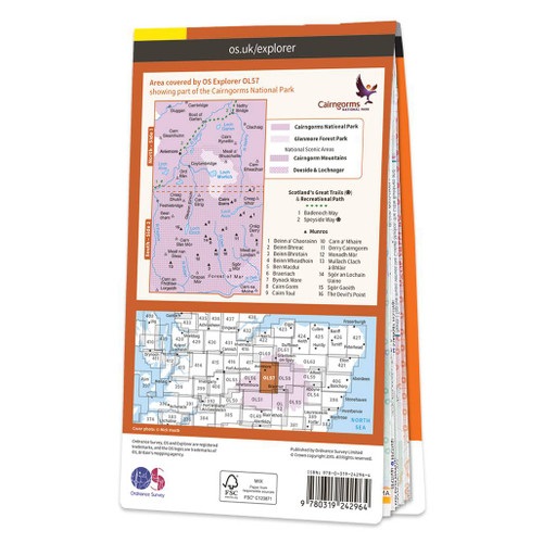
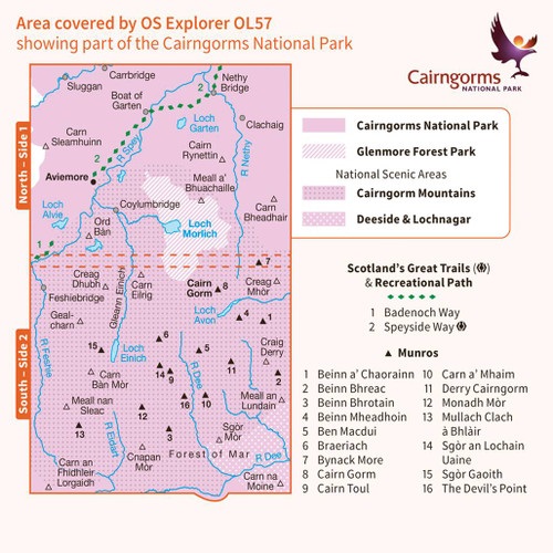
Wandelkaart - Topografische kaart OL57 OS Explorer Map Cairn Gorm & Aviemore | Ordnance Survey (9780319242964)
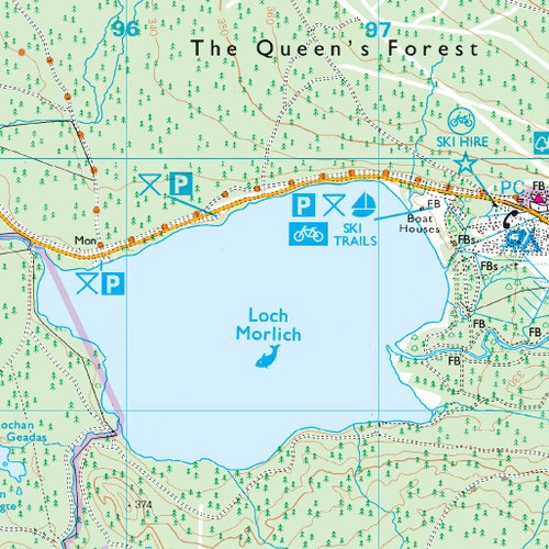
Loch Morlich

- ISBN / CODE: 9780319242964
- Editie: 2022
- Aantal blz.: 1
- Schaal: 1:25000
- Uitgever: Ordnance Survey
- Soort: Topografische kaart, Wandelkaart
- Serie: OS Explorer Map
- Taal: Engels
- Hoogte: 23.0 cm
- Breedte: 13.0 cm
- Dikte: 1.0 cm
- Gewicht: 150.0 g
- Uitvoering: Papier
- Bindwijze: -
- Beoordeling: 4,3 ★★★★★ ★★★★★ (3 reviews) Schrijf een review
-
€ 19,50
Levertijd 2 - 4 werkdagen in huis in Nederland Levertijd Belgie
Gratis verzending in Nederland vanaf €35,-
-
Overzichtskaart Explorer 25.000 topografische kaarten Noordoost Schotland - Cairngorms

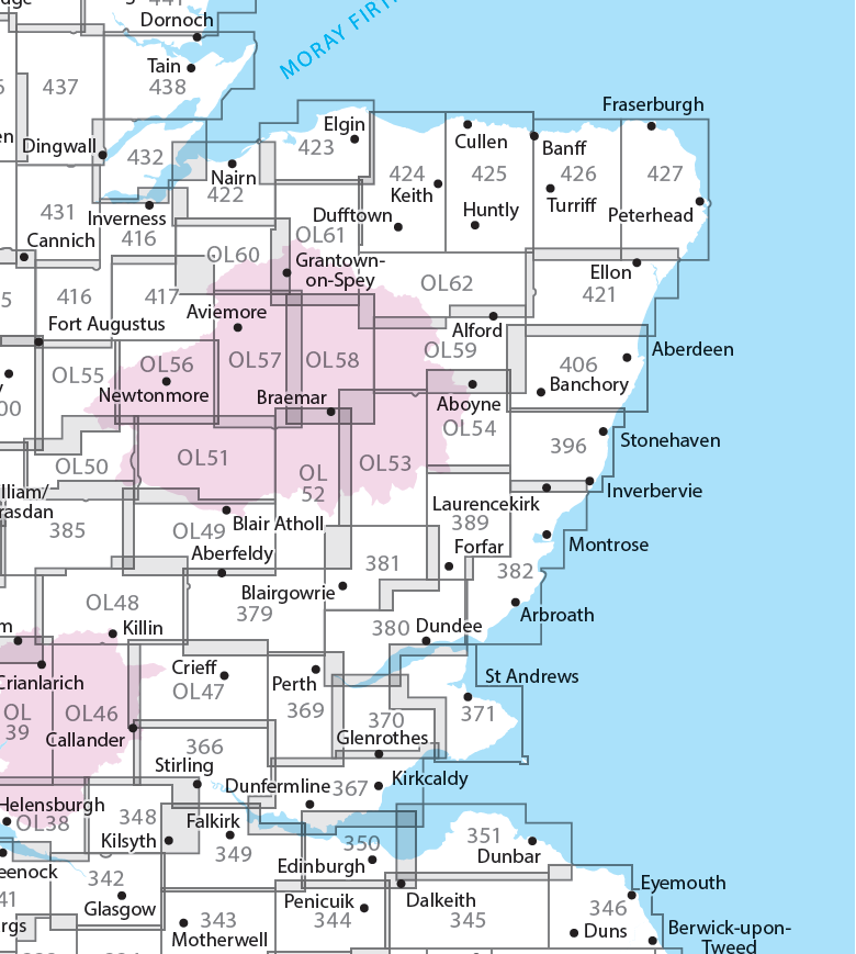
Producten op deze overzichtskaart:
Klik op een product om naar de pagina van dat product te gaan.
- Wandelkaart - Topografische kaart 342 OS Explorer Map Glasgow | Ordnance Survey
- Wandelkaart - Topografische kaart 348 OS Explorer Map Campsie Fells | Ordnance Survey
- Wandelkaart - Topografische kaart 349 OS Explorer Map Falkirk, Cumbernauld, Livingston | Ordnance Survey
- Wandelkaart - Topografische kaart 350 OS Explorer Map Edinburgh | Ordnance Survey
- Wandelkaart - Topografische kaart 351 OS Explorer Map Dunbar, North Berwick | Ordnance Survey
- Wandelkaart - Topografische kaart 366 OS Explorer Map Stirling, Ochil Hills West | Ordnance Survey
- Wandelkaart - Topografische kaart 367 OS Explorer Map Dunfermline, Kirkcaldy, Glenrothes South | Ordnance Survey
- Wandelkaart - Topografische kaart 369 OS Explorer Map Perth, Kinross | Ordnance Survey
- Wandelkaart - Topografische kaart 370 OS Explorer Map Glenrothes North, Falkland, Lomond Hills | Ordnance Survey
- Wandelkaart - Topografische kaart 371 OS Explorer Map St-Andrews, East Fife | Ordnance Survey
- Wandelkaart - Topografische kaart 379 OS Explorer Map Dunkeld, Aberfeldy, Glen Almond | Ordnance Survey
- Wandelkaart - Topografische kaart 380 OS Explorer Map Dundee, Sidlaw Hills | Ordnance Survey
- Wandelkaart - Topografische kaart 381 OS Explorer Map Blairgowrie, Kirriemuir, Glamis | Ordnance Survey
- Wandelkaart - Topografische kaart 382 OS Explorer Map Arbroath, Montrose, Carnoustie | Ordnance Survey
- Wandelkaart - Topografische kaart 385 OS Explorer Map Rannoch Moor, Ben Alder | Ordnance Survey
- Wandelkaart - Topografische kaart 389 OS Explorer Map Forfar, Brechin, Edzell | Ordnance Survey
- Wandelkaart - Topografische kaart 396 OS Explorer Map Stonehaven, Inverbervie & Laurencekirk | Ordnance Survey
- Wandelkaart - Topografische kaart 406 OS Explorer Map Aberdeen, Banchory | Ordnance Survey
- Wandelkaart - Topografische kaart 416 OS Explorer Map Inverness, Loch Ness, Culloden | Ordnance Survey
- Wandelkaart - Topografische kaart 417 OS Explorer Map Monadhliath Mountains North, Strathdearn | Ordnance Survey
- Wandelkaart - Topografische kaart 421 OS Explorer Map Ellon & Inverurie, explorer | Ordnance Survey
- Wandelkaart - Topografische kaart 422 OS Explorer Map Nairn, Cawdor | Ordnance Survey
- Wandelkaart - Topografische kaart 423 OS Explorer Map Elgin, Forres, Lossiemouth | Ordnance Survey
- Wandelkaart - Topografische kaart 424 OS Explorer Map Buckie, Keith | Ordnance Survey
- Wandelkaart - Topografische kaart 425 OS Explorer Map Huntly, Cullen | Ordnance Survey
- Wandelkaart - Topografische kaart 426 OS Explorer Map Banff, Macduff, Turriff | Ordnance Survey
- Wandelkaart - Topografische kaart 427 OS Explorer Map Peterhead, Fraserburgh | Ordnance Survey
- Wandelkaart - Topografische kaart 431 OS Explorer Map Glen Urquhart, Strathglass | Ordnance Survey
- Wandelkaart - Topografische kaart 432 OS Explorer Map Black Isle | Ordnance Survey
- Wandelkaart - Topografische kaart OL46 OS Explorer Map The Trossachs | Ordnance Survey
- Wandelkaart - Topografische kaart OL47 OS Explorer Map Crieff, Comrie & Glen Artney | Ordnance Survey
- Wandelkaart - Topografische kaart OL48 OS Explorer Map Ben Lawers & Glen Lyon | Ordnance Survey
- Wandelkaart - Topografische kaart OL49 OS Explorer Map Pitlochry & Loch Tummel | Ordnance Survey
- Wandelkaart - Topografische kaart OL50 OS Explorer Map Ben Alder, Loch Ericht & Loch Laggan | Ordnance Survey
- Wandelkaart - Topografische kaart OL51 OS Explorer Map Atholl | Ordnance Survey
- Wandelkaart - Topografische kaart OL52 OS Explorer Map | Active Glen Shee - Braemar | Ordnance Survey
- Wandelkaart - Topografische kaart OL53 OS Explorer Map Lochnagar, Glen Muick & Glen Clova | Ordnance Survey
- Wandelkaart - Topografische kaart OL54 OS Explorer Map Glen Esk & Glen Tanar | Ordnance Survey
- Wandelkaart - Topografische kaart OL55 OS Explorer Map Loch Laggan & Creag Meagaidh | Ordnance Survey
- Wandelkaart - Topografische kaart OL56 OS Explorer Map Badenoch & Upper Strathspey | Ordnance Survey
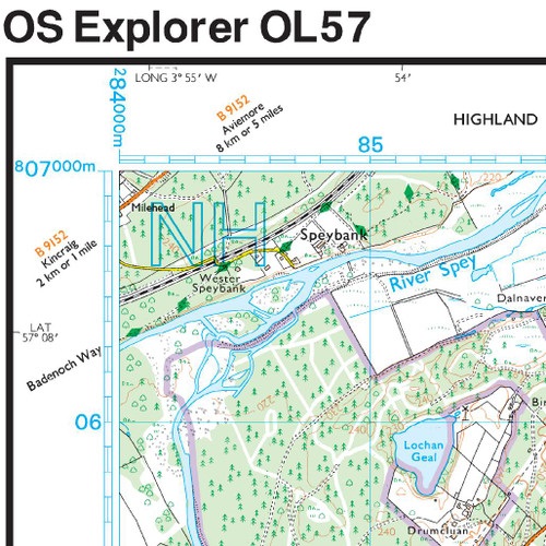
- Wandelkaart - Topografische kaart OL57 OS Explorer Map Cairn Gorm & Aviemore | Ordnance Survey
- Wandelkaart - Topografische kaart OL58 OS Explorer Map Braemar, Tomintoul & Glen Avon | Ordnance Survey
- Wandelkaart - Topografische kaart OL59 OS Explorer Map Aboyne, Alford & Strathdon | Ordnance Survey
- Wandelkaart - Topografische kaart OL60 OS Explorer Map Lochindorb, Grantown-on-Spey & Carrbridge | Ordnance Survey
- Wandelkaart - Topografische kaart OL61 OS Explorer Map Grantown-on-Spey & Hills of Cromdale | Ordnance Survey
- Wandelkaart - Topografische kaart OL62 OS Explorer Map Coreen Hills & Glenlivet | Ordnance Survey
-
Overzichtskaart Explorer 25.000 wandelkaarten Noordoost Schotland - Cairngorms

Producten op deze overzichtskaart:
Klik op een product om naar de pagina van dat product te gaan.
- Wandelkaart - Topografische kaart 342 OS Explorer Map Glasgow | Ordnance Survey
- Wandelkaart - Topografische kaart 348 OS Explorer Map Campsie Fells | Ordnance Survey
- Wandelkaart - Topografische kaart 349 OS Explorer Map Falkirk, Cumbernauld, Livingston | Ordnance Survey
- Wandelkaart - Topografische kaart 350 OS Explorer Map Edinburgh | Ordnance Survey
- Wandelkaart - Topografische kaart 351 OS Explorer Map Dunbar, North Berwick | Ordnance Survey
- Wandelkaart - Topografische kaart 366 OS Explorer Map Stirling, Ochil Hills West | Ordnance Survey
- Wandelkaart - Topografische kaart 367 OS Explorer Map Dunfermline, Kirkcaldy, Glenrothes South | Ordnance Survey
- Wandelkaart - Topografische kaart 369 OS Explorer Map Perth, Kinross | Ordnance Survey
- Wandelkaart - Topografische kaart 370 OS Explorer Map Glenrothes North, Falkland, Lomond Hills | Ordnance Survey
- Wandelkaart - Topografische kaart 371 OS Explorer Map St-Andrews, East Fife | Ordnance Survey
- Wandelkaart - Topografische kaart 379 OS Explorer Map Dunkeld, Aberfeldy, Glen Almond | Ordnance Survey
- Wandelkaart - Topografische kaart 380 OS Explorer Map Dundee, Sidlaw Hills | Ordnance Survey
- Wandelkaart - Topografische kaart 381 OS Explorer Map Blairgowrie, Kirriemuir, Glamis | Ordnance Survey
- Wandelkaart - Topografische kaart 382 OS Explorer Map Arbroath, Montrose, Carnoustie | Ordnance Survey
- Wandelkaart - Topografische kaart 385 OS Explorer Map Rannoch Moor, Ben Alder | Ordnance Survey
- Wandelkaart - Topografische kaart 389 OS Explorer Map Forfar, Brechin, Edzell | Ordnance Survey
- Wandelkaart - Topografische kaart 396 OS Explorer Map Stonehaven, Inverbervie & Laurencekirk | Ordnance Survey
- Wandelkaart - Topografische kaart 406 OS Explorer Map Aberdeen, Banchory | Ordnance Survey
- Wandelkaart - Topografische kaart 416 OS Explorer Map Inverness, Loch Ness, Culloden | Ordnance Survey
- Wandelkaart - Topografische kaart 417 OS Explorer Map Monadhliath Mountains North, Strathdearn | Ordnance Survey
- Wandelkaart - Topografische kaart 421 OS Explorer Map Ellon & Inverurie, explorer | Ordnance Survey
- Wandelkaart - Topografische kaart 422 OS Explorer Map Nairn, Cawdor | Ordnance Survey
- Wandelkaart - Topografische kaart 423 OS Explorer Map Elgin, Forres, Lossiemouth | Ordnance Survey
- Wandelkaart - Topografische kaart 424 OS Explorer Map Buckie, Keith | Ordnance Survey
- Wandelkaart - Topografische kaart 425 OS Explorer Map Huntly, Cullen | Ordnance Survey
- Wandelkaart - Topografische kaart 426 OS Explorer Map Banff, Macduff, Turriff | Ordnance Survey
- Wandelkaart - Topografische kaart 427 OS Explorer Map Peterhead, Fraserburgh | Ordnance Survey
- Wandelkaart - Topografische kaart 431 OS Explorer Map Glen Urquhart, Strathglass | Ordnance Survey
- Wandelkaart - Topografische kaart 432 OS Explorer Map Black Isle | Ordnance Survey
- Wandelkaart - Topografische kaart OL46 OS Explorer Map The Trossachs | Ordnance Survey
- Wandelkaart - Topografische kaart OL47 OS Explorer Map Crieff, Comrie & Glen Artney | Ordnance Survey
- Wandelkaart - Topografische kaart OL48 OS Explorer Map Ben Lawers & Glen Lyon | Ordnance Survey
- Wandelkaart - Topografische kaart OL49 OS Explorer Map Pitlochry & Loch Tummel | Ordnance Survey
- Wandelkaart - Topografische kaart OL50 OS Explorer Map Ben Alder, Loch Ericht & Loch Laggan | Ordnance Survey
- Wandelkaart - Topografische kaart OL51 OS Explorer Map Atholl | Ordnance Survey
- Wandelkaart - Topografische kaart OL52 OS Explorer Map | Active Glen Shee - Braemar | Ordnance Survey
- Wandelkaart - Topografische kaart OL53 OS Explorer Map Lochnagar, Glen Muick & Glen Clova | Ordnance Survey
- Wandelkaart - Topografische kaart OL54 OS Explorer Map Glen Esk & Glen Tanar | Ordnance Survey
- Wandelkaart - Topografische kaart OL55 OS Explorer Map Loch Laggan & Creag Meagaidh | Ordnance Survey
- Wandelkaart - Topografische kaart OL56 OS Explorer Map Badenoch & Upper Strathspey | Ordnance Survey
- Wandelkaart - Topografische kaart OL57 OS Explorer Map Cairn Gorm & Aviemore | Ordnance Survey
- Wandelkaart - Topografische kaart OL58 OS Explorer Map Braemar, Tomintoul & Glen Avon | Ordnance Survey
- Wandelkaart - Topografische kaart OL59 OS Explorer Map Aboyne, Alford & Strathdon | Ordnance Survey
- Wandelkaart - Topografische kaart OL60 OS Explorer Map Lochindorb, Grantown-on-Spey & Carrbridge | Ordnance Survey
- Wandelkaart - Topografische kaart OL61 OS Explorer Map Grantown-on-Spey & Hills of Cromdale | Ordnance Survey
- Wandelkaart - Topografische kaart OL62 OS Explorer Map Coreen Hills & Glenlivet | Ordnance Survey
Overzichtskaarten
Beschrijving
Met zijn 4cm voor 1 km (2 ½ cm voor 1 mijl) schaal, is de OS Outdoor Leisure kaartenserie de ideale en meest gedetailleerde kaartenreeks voor mensen die graag outdoor-activiteiten zoals fietsen, wandelen, paardrijden, klimmen en watersporten.
Dit product heeft meerdere varianten:

Reviews
In 1ste instantie had ik de 'waterkaart' besteld van de Cairngorms. Die vond ik te groot en te zwaar. Nu de 'droge' versie besteld. Wat zijn het toch een ongelofelijk mooie detailleerde kaarten. Echt alles staat erop.
★★★★★ door Riekele van der Heide 30 september 2025 | Heeft dit artikel gekochtVond u dit een nuttige review? (login om te beoordelen)
Prima kaart mooie details. Bleek ook in watervaste uitvoering verkrijgbaar te zijn. Als ik dat had geweten, ivm Schotse weer.
★★★★★ door Martin-55 27 september 2019 | Heeft dit artikel gekochtVond u dit een nuttige review? (login om te beoordelen)
Prachtige kaart met goede details. Het enige waar ik me in heb vergist, is dat de kaart niet waterbestendig is.
★★★★★ door Brian 25 januari 2018Vond u dit een nuttige review? (login om te beoordelen)
Schrijf een review
Graag horen wij wat u van dit artikel vindt. Vindt u het goed, leuk, mooi, slecht, lelijk, onbruikbaar of erg handig: schrijf gerust alles op! Het is niet alleen leuk om te doen maar u informeert andere klanten er ook nog mee!
Ook interessant voor europa/schotland/overig-noord
-

Wandelgids 030 Pathfinder Guides Loc
€ 18,95Wandelgidsen Schotse Hooglanden & Speyside -

Wegenkaart - landkaart 2 OS Road Map
€ 12,95Wegenkaarten Schotse Hooglanden & Speyside -

Wandelkaart - Topografische kaart 28
€ 25,95Topografische kaarten Schotse Hooglanden & Speyside -

Wandelkaart - Topografische kaart 02
€ 19,50Topografische kaarten Schotse Hooglanden & Speyside -

Wegenkaart - landkaart 1 North Scotl
€ 12,95Wegenkaarten Schotse Hooglanden & Speyside