Categorieën
- Nieuwe artikelen
- Boeken
-
Kaarten
- Camperkaarten
- Educatieve kaarten
- Fietskaarten
- Fietsknooppuntenkaarten
- Historische Kaarten
- Mountainbike kaarten
- Pelgrimsroutes (kaarten)
- Spoorwegenkaarten
- Stadsplattegronden
- Toerskikaarten
- Topografische kaarten
- Wandelatlassen
- Wandelkaarten
- Wandelknooppuntenkaarten
- Wateratlassen
- Waterkaarten
- Wegenatlassen
-
Wegenkaarten
- Afrika
- Azië
-
Europa
- Albanië
- Andorra
- Armenië
- Azerbeidzjan
- Belarus - Witrusland
- België
- Bosnië - Hercegovina
- Bulgarije
- Cyprus
- De Alpen
- Denemarken
- Duitsland
- Engeland
- Estland
- Faroer
- Finland
-
Frankrijk
- Picardie - Noordwest Frankrijk
- Hauts-de-France
- Grand-Est
- Champagne - Ardennen
- Normandië
- Bretagne
- Pays de la Loire
- Dordogne - Limousin
- Franse Atlantische Kust - Nouvelle-Aquitaine
- Aquitaine
- Limousin
- Poitou-Charentes
- Vogezen - Elzas - Lotharingen
- Île-de-France
- Bourgogne - Franche-Comté
- Franche-Comté
- Bourgondië
- Auvergne - Rhône-Alpes
- Auvergne
- Rhône-Alpes
- Franse Alpen
- Alpen - Mont Blanc - Haute Savoie
- Alpen - Vanoise - Savoie
- Alpen - Vaucluse - Drome - Vercors
- Pyreneeën
- Occitanie
- Languedoc - Rousillon
- Cevennen
- Midi-Pyrénées
- Centre - Val de Loire
- Provence - Alpes-Côte d’Azur
- Cote d'Azur - Franse Riviera
- Provence
- Corsica
- Lille - Rijsel
- Parijs
- Rennes
- Straatsburg
- 🥾 Wandelroute naar Santiago de Compostela
- Georgië
- Griekenland
- Groenland
- Hongarije
- IJsland
- Ierland
- Italië
- Kosovo
- Kroatië
- Letland
- Liechtenstein
- Litouwen
- Luxemburg
- Malta
- Moldavië
- Monaco
- Montenegro
- Nederland
- Noord-Ierland
- Noord-Macedonië
- Noorwegen
- Oekraïne
- Oostenrijk
- Polen
- Portugal
- Roemenië
- Rusland
- Scandinavië
- Schotland
- Servië
- Slovenië
- Slowakije
- Spanje
- Tsjechië
- Turkije
- Vaticaanstad
- Zweden
- Zwitserland
- Midden-Amerika
- Midden-Oosten
- Noord-Amerika
- Oceanië
- Wereld
- Zuid-Amerika
- Wintersportkaarten
- Opruiming
- Puzzels
- Travel Gadgets
- Wandkaarten
- Wereldbollen
Veilig online betalen
Betaal veilig via uw eigen bankomgeving
- U bent hier:
- Home
- Europa
- Frankrijk
- Kaarten
- Wegenkaarten
Geen items in winkelwagen
Ga naar winkelwagen
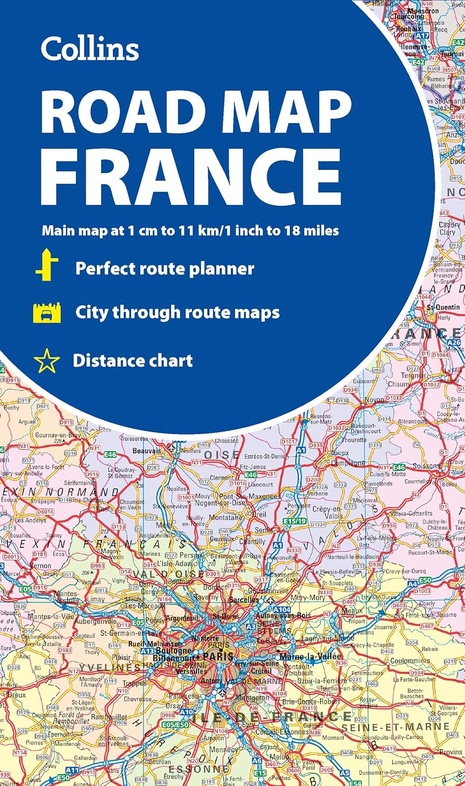
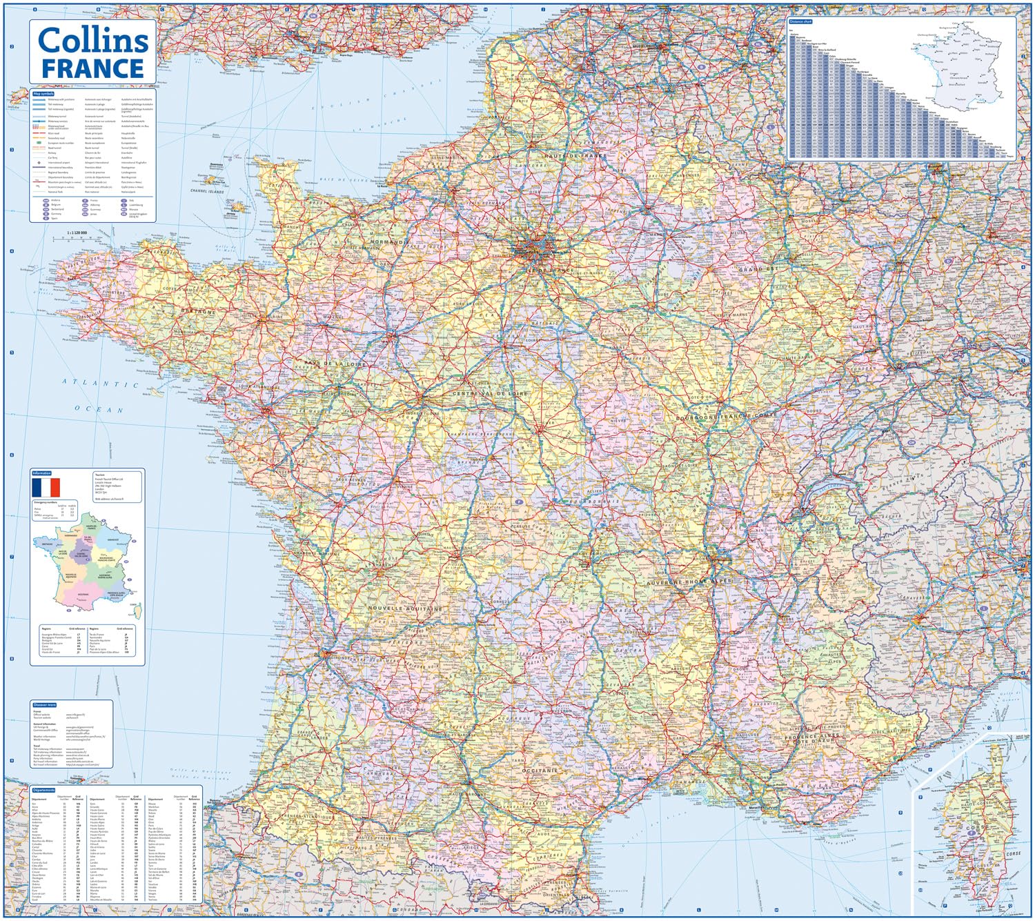
Wegenkaart - landkaart France road map | Collins (9780008716486)
- ISBN / CODE: 9780008716486
- Editie: 16-01-2025
- Aantal blz.: 1
- Uitgever: Collins
- Soort: Wegenkaart
- Taal: Engels
- Hoogte: 14.0 cm
- Breedte: 9.0 cm
- Gewicht: 100.0 g
- Uitvoering: Papier
- Bindwijze: -
- Schrijf als eerste een review
-
€ 12,95
Dit artikel is (tijdelijk) niet leverbaar Dit artikel is (tijdelijk) niet leverbaar
- Afbeeldingen
- Inkijkexemplaar


Beschrijving
Van de uitgever
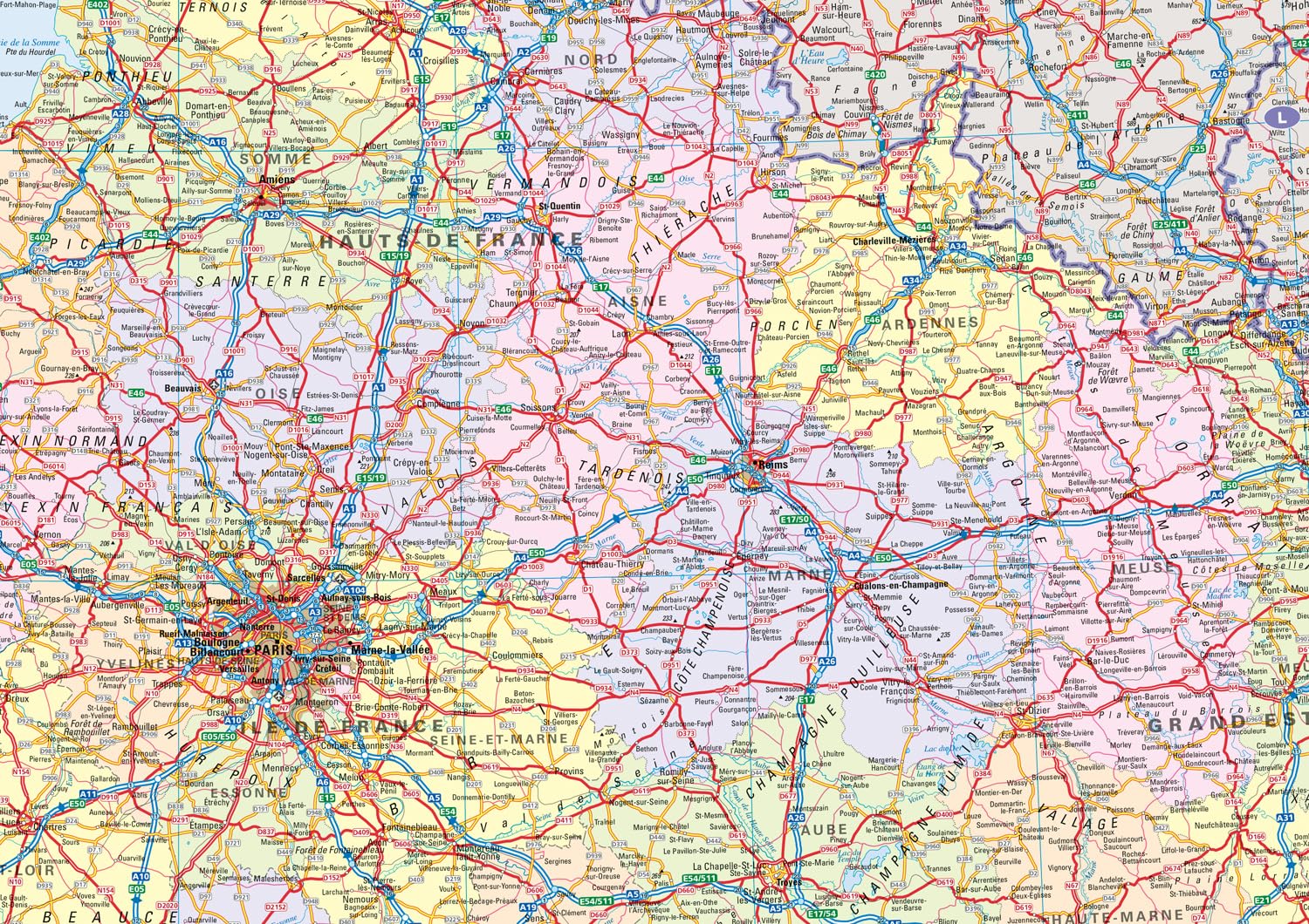
A fully revised and updated colour road map of France at 18 miles to 1 inch / 11km to 1cm. The map shows individual departments by name. All cities, towns, roads, European route numbers, motorways and toll motorways are clearly shown, making it the ideal map for planning and route-finding.The map shows the road network in detail for easy route planning.
Main features
• Fully revised and updated
Clear, detailed road network
Through-route maps of Paris, Lyon, Marseille, Strasbourg, and Toulouse
Distance chart giving distances in kilometres between main towns
Key to department names and numbers, and list of regions
Internet links to further information
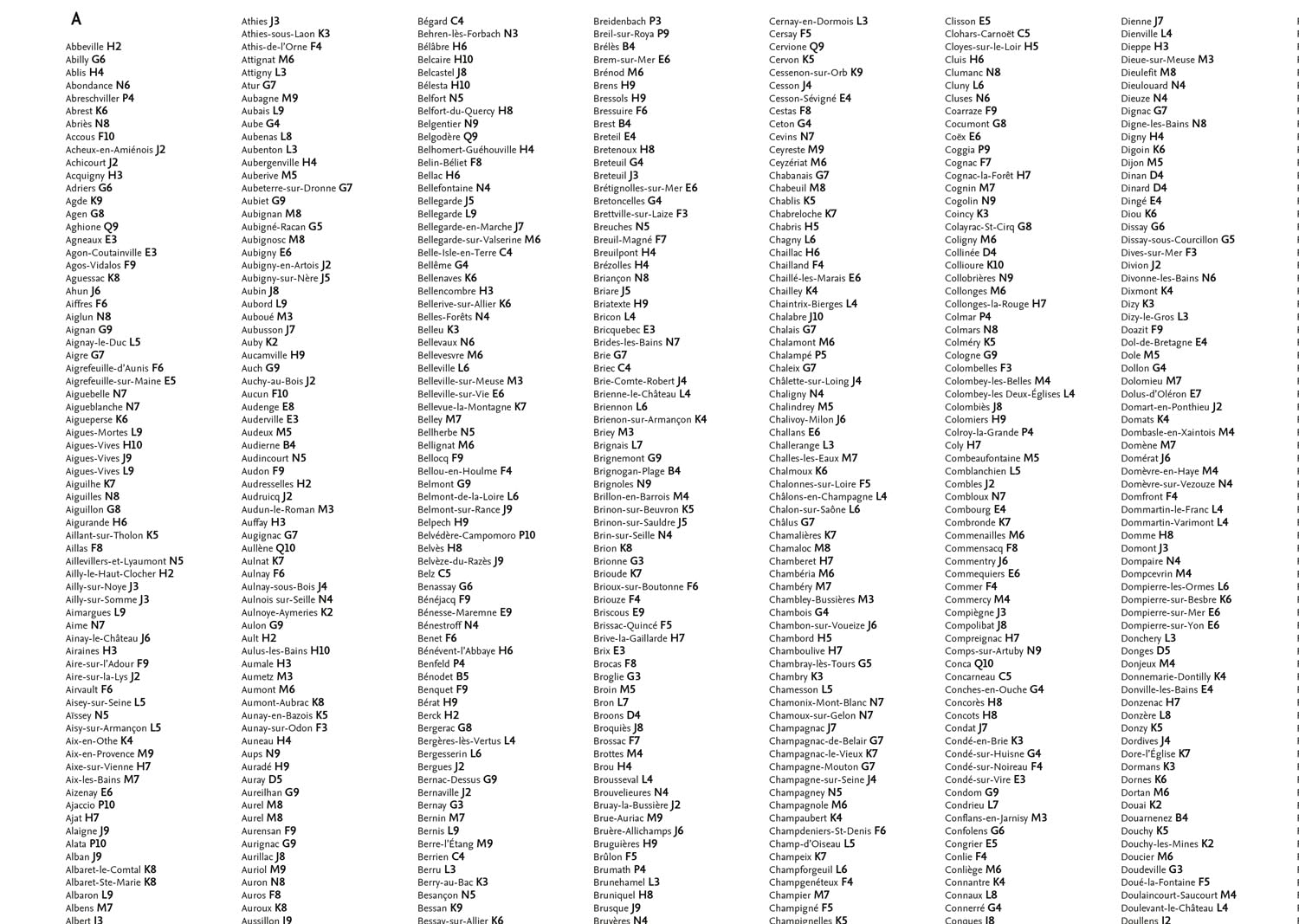
Full Index to place names
Map key in English, French and German
Reviews
Geen reviews gevonden voor dit product.
Schrijf een review
Graag horen wij wat u van dit artikel vindt. Vindt u het goed, leuk, mooi, slecht, lelijk, onbruikbaar of erg handig: schrijf gerust alles op! Het is niet alleen leuk om te doen maar u informeert andere klanten er ook nog mee!
Alle gerelateerde rubrieken >
Ook interessant voor europa/frankrijk
-

Wegenkaart - landkaart 1 Frankrijk |
€ 12,99Wegenkaarten Frankrijk -

Reliëfkaart 60178 Mercantour / Côte
€ 139,95Reliëfkaarten Mercantour -

Wandelkaart 42 Costabona | Editorial
€ 16,95Wandelkaarten Girona (Provincie) -
 | Rough Guides")
Reisgids Mini Rough Guide Frankrijk
€ 12,50Reisgidsen Frankrijk -

Wandkaart France Political Map | 118
€ 29,95Wandkaarten van landen Frankrijk