Categorieën
- Nieuwe artikelen
-
Boeken
- Aanwijswoordenboeken
- Accommodatiegidsen
- Atlassen
- Bed and Breakfast Gidsen
- Campergidsen
- Camperhandboeken
- Campinggidsen
- Duikgidsen
- Fietsatlassen
- Fietsgidsen
- Fotoboeken
- Historische Atlassen
- Kanogidsen
- Kinderatlassen
- Kinderreisgidsen
- Kleurboeken
- Klimgids - Klettersteiggidsen
- Kookboeken
- Mountainbikegidsen
- Natuurgidsen
- Pelgrimsroutes
- Reisboeken
- Reisdagboeken
- Reisfotografiegidsen
- Reisgidsen
- Reishandboeken
- Reisinspiratieboeken
- Reisverhalen
- Sneeuwschoenwandelgidsen
- Survivalgidsen
- Tourskigidsen
- Treinreisgidsen
- Vaargidsen
- Vogelgidsen
-
Wandelgidsen
- Afrika
- Azië
-
Europa
- Albanië
- Andorra
- Armenië
- België
- Bosnië - Hercegovina
- Bulgarije
- Cyprus
- Denemarken
- Duitsland
-
Engeland
- Noord Engeland
- North East England
- ♦ Northumberland National Park
- Yorkshire and the Humber
- ♦ Yorkshire Dales Nationaal Park
- ♦ North York Moors Nationaal Park
- North West England
- ♦ Cumbria
- ♦ Isle of Man
- ♦ Lake District Nationaal Park
- ♦ North Pennines AONB
- 🥾 Hadrian's Wall Path
- East Midlands
- West Midlands
- ♦ Peak District Nationaal Park
- Wales
- ♦ Pembrokeshire Coast National Park
- ♦ Snowdonia Nationaal Park
- ♦ Brecon Beacons Nationaal Park
- East of England - East Anglia
- South West England
- ♦ Cotswolds AONB
- ♦ Devon - Cornwall
- 🥾 South West Coast Path
- ♦ New Forrest National Park
- ♦ Exmoor National Park
- ♦ Dartmoor National Park
- South East England
- ♦ Kent
- ♦ South Downs Nationaal Park
- ♦ Isle of Wight
- Kanaaleilanden
- Londen
- Oxford
- Meer steden
- Estland
- Faroer
- Finland
- Frankrijk
- Georgië
- Griekenland
- Groenland
- Hongarije
- IJsland
- Ierland
- Italië
- Kosovo
- Kroatië
- Letland
- Liechtenstein
- Litouwen
- Luxemburg
- Malta
- Montenegro
- Nederland
- Noord-Ierland
- Noord-Macedonië
- Noorwegen
- Oostenrijk
- Polen
- Portugal
- Roemenië
- Scandinavië
- Schotland
- Servië
- Slovenië
- Slowakije
- Spanje
- Tsjechië
- Turkije
- Zweden
- Zwitserland
- Midden-Amerika
- Midden-Oosten
- Noord-Amerika
- Oceanië
- Wereld
- Zuid-Amerika
- Watersport handboeken
- Werken en wonen in buitenland
- Woordenboeken & Taalgidsen
- Kaarten
- Opruiming
- Puzzels
- Travel Gadgets
- Wandkaarten
- Wereldbollen
Veilig online betalen
Betaal veilig via uw eigen bankomgeving
- U bent hier:
- Home
- Europa
- Engeland
- Yorkshire and the Humber
- Boeken
- Wandelgidsen
Geen items in winkelwagen
Ga naar winkelwagen
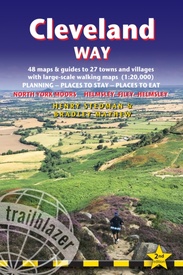
Wandelgids Cleveland Way | Trailblazer Guides (9781912716494)
North York Moors - Helmsley to Filey
- ISBN / CODE: 9781912716494
- Editie: 2024
- Aantal blz.: 208
- Auteur(s): Henry Stedman
- Uitgever: Trailblazer Guides
- Soort: Wandelgids
- Taal: Engels
- Hoogte: 18.5 cm
- Breedte: 12.2 cm
- Dikte: 1.2 cm
- Bindwijze: Paperback
- Uitvoering: -
- Schrijf als eerste een review
-
€ 19,95
Dit artikel is (tijdelijk) niet leverbaar Dit artikel is (tijdelijk) niet leverbaar
- Extra Info
- Inkijkexemplaar
PDF wordt ingeladen...
Beschrijving
All the information you need to enjoy your hiking adventure along the Cleveland Way in this fully revised and updated 2nd edition. In the beautiful, wild countryside of the North York Moors National Park in northern England lies this fabulous trail, the Cleveland Way. The 110-mile route runs from Helmsley near Thirsk around the western edge of the park to reach the coast at Saltburn-by-the-Sea.
It then continues along the eastern edge of the park south down the coast through Whitby, Robin Hood's Bay and Scarborough to finish in Filey. Combining moorland and coast there's wonderful scenic variety to this walk, with crumbling castles and idyllic fishing villages to explore. The guide includes:48 large-scale walking maps - at just under 1:20,000 - showing route times, places to stay, places to eat, points of interest, and 8 town plans10 colour stage maps to help plan your walk, including hills and descents, and two colour overview mapsPlaces to stay with reviews - campsites, bunkhouses, hostels, B&Bs, pubs and hotelsPlaces to eat with reviews - cafes, teashops, pubs, takeaways, restaurantsWhat to see from the path - history, culture, natural historyComprehensive public transport information - for all access points on the WayFlora and fauna - four page full colour flower guide, plus an illustrated section on local wildlifeItineraries for all walkers - whether walking the route in its entirety over two weeks or sampling the highlights on day walks and short breaksGreen hiking - understanding the local environment and minimizing our impact on itGPS waypoints
Reviews
Geen reviews gevonden voor dit product.
Schrijf een review
Graag horen wij wat u van dit artikel vindt. Vindt u het goed, leuk, mooi, slecht, lelijk, onbruikbaar of erg handig: schrijf gerust alles op! Het is niet alleen leuk om te doen maar u informeert andere klanten er ook nog mee!
Alle gerelateerde rubrieken >
Ook interessant voor europa/engeland/yorkshire-and-the-humber
-

Fietskaart mountainbike Coast to Coa
€ 28,50Fietskaarten Yorkshire and the Humber -

Wandelgids Coast to Coast Walk - van
€ 20,95Wandelgidsen Yorkshire and the Humber -

Wegenkaart - landkaart National Park
€ 7,95Wegenkaarten Yorkshire and the Humber -

Reisgids Slow Travel North York Moor
€ 22,50Reisgidsen Yorkshire and the Humber -

Wandelkaart - Topografische kaart 28
€ 19,50Topografische kaarten Yorkshire and the Humber


