Wegenkaart - landkaart Canarische Eilanden | ITMB (9781771291965)
- ISBN / CODE: 9781771291965
- Editie: 01-01-2026
- Druk: 2
- Aantal blz.: 1
- Schaal: 1:130000
- Uitgever: ITMB
- Soort: Wegenkaart
- Taal: Engels
- Hoogte: 25.0 cm
- Breedte: 10.0 cm
- Gewicht: 52.0 g
- Uitvoering: Papier
- Bindwijze: -
- Schrijf als eerste een review
-
€ 13,95
Leverbaar in 3 - 5 werkdagen in huis in Nederland Levertijd Belgie
Gratis verzending in Nederland vanaf €35,-
Beschrijving
Van de uitgever
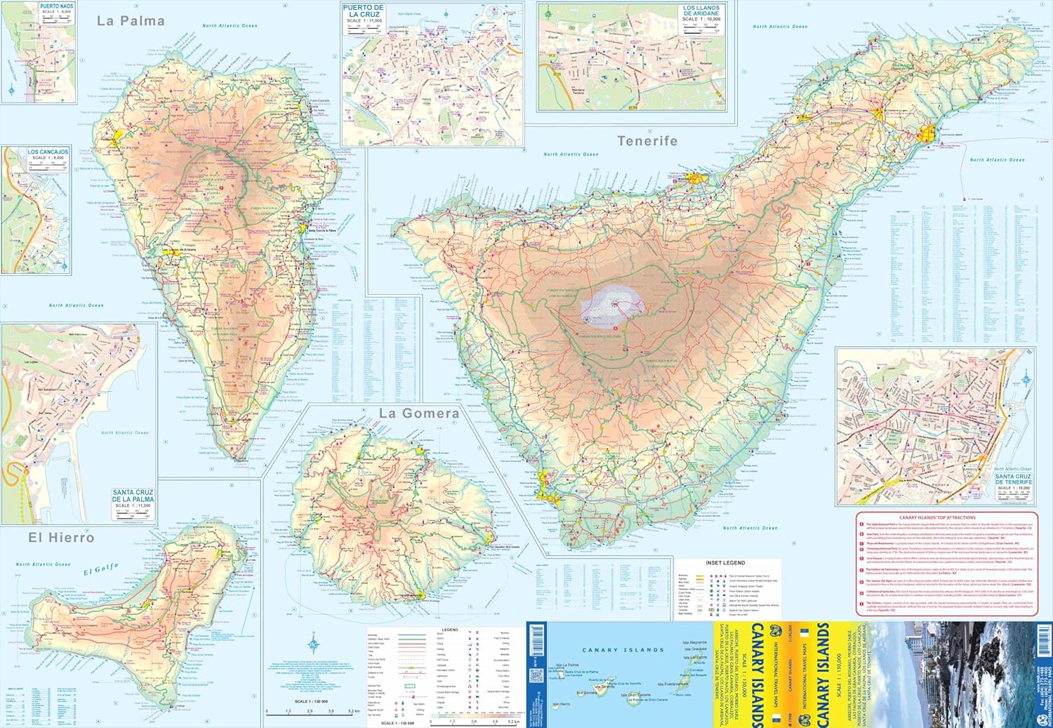
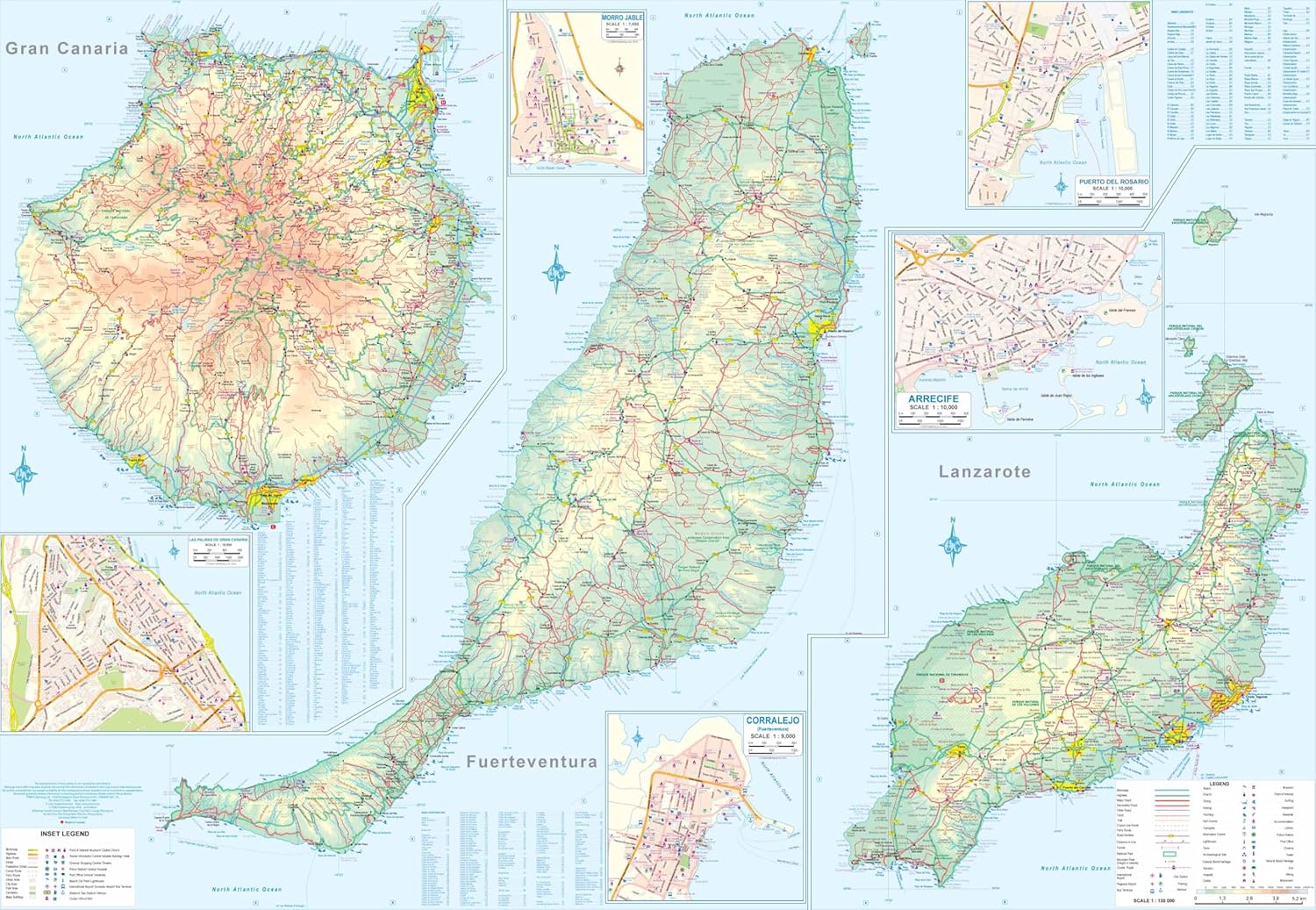
Natuurkundige wegenkaart met veel plaatsen en wegen, spoorlijnen en rivieren, hoogten, lengte- en breedtegraden.
The Canaries are one of the largest travel destinations in the world; ideal for soaking up sunshine, engaging in water activities, or exploring. All the islands have been included on this map, as well as the ferry routes connecting. Naturally, airports, roads, major resorts, towns, beaches, parks, hiking trails, and touristic attractions are included. Each island is shown at the same scale and with the same attention to detail. As well, several inset maps of urban areas has been included, such as Santa Cruz de la Palma, Cancajos, Los Llanos de Aridane and Puerto Naos on La Palma, Santa Cruz on Tenerife, Las Palmas on Gran Canaria, Corralejo on Fuerteventura, Arricife on Lanzarote, and a couple of other towns. This is an excellent travel friendly map, easy to read and to use.
Reviews
Geen reviews gevonden voor dit product.
Schrijf een review
Graag horen wij wat u van dit artikel vindt. Vindt u het goed, leuk, mooi, slecht, lelijk, onbruikbaar of erg handig: schrijf gerust alles op! Het is niet alleen leuk om te doen maar u informeert andere klanten er ook nog mee!
Ook interessant voor europa/spanje/canarischeeilanden
-

Reisgids Fuerteventura | Michael Mül
€ 21,95Reisgidsen Canarische Eilanden -

Wandelkaart 237 Gran Canaria | Kompa
€ 13,95Wandelkaarten Canarische Eilanden -

Vogelgids Birds of the Atlantic Isla
€ 59,95Vogelgidsen Azoren -
 | Rother Bergverlag")
Wandelgids La Gomera (Engelstalig) |
€ 20,95Wandelgidsen Canarische Eilanden -

Wegenkaart - landkaart 11630 Canarie
€ 11,95Wegenkaarten Canarische Eilanden