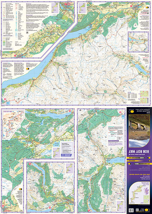
Wandelkaart Rob Roy Way | Harvey Maps (9781851375196)
Drymen to Pitlochry

- ISBN / CODE: 9781851375196
- Editie: 01-06-2022
- Aantal blz.: 1
- Schaal: 1:40000
- Uitgever: Harvey Maps
- Soort: Wandelkaart
- Serie: National Trail Maps
- Taal: Engels
- Hoogte: 25.0 cm
- Breedte: 14.0 cm
- Gewicht: 74.0 g
- Uitvoering: Scheur- en watervast
- Bindwijze: -
- Schrijf als eerste een review
-
€ 26,95
Leverbaar in 3 - 5 werkdagen in huis in Nederland Levertijd Belgie
Gratis verzending in Nederland vanaf €50,-


-
Overzicht National Trail Maps Harvey Maps

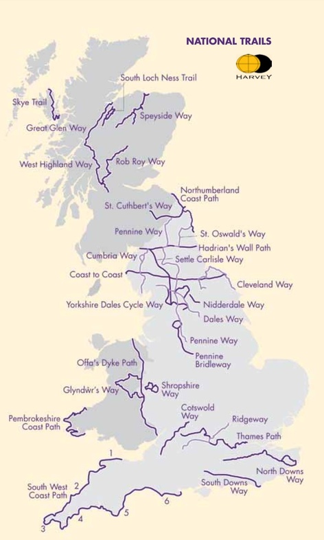
Producten op deze overzichtskaart:
Klik op een product om naar de pagina van dat product te gaan.
- Wandelkaart 1 South West Coast Path 1 | Harvey Maps
- Wandelkaart 3 South West Coast Path 3 | Harvey Maps
- Wandelkaart Affric Kintail Way | Harvey Maps
- Wandelkaart Anglesey Coastal Path | Harvey Maps
- Wandelkaart Beacons Way XT40 | Harvey Maps
- Wandelkaart Cambrian Way North XT40 | Harvey Maps
- Wandelkaart Cape Wrath Trail North | Harvey Maps
- Wandelkaart Cape Wrath Trail South | Harvey Maps
- Wandelkaart Cleveland Way | Harvey Maps
- Wandelkaart Coast to Coast | Harvey Maps
- Wandelkaart Cotswold Way | Harvey Maps
- Wandelkaart Cumbria Way | Harvey Maps
- Wandelkaart Cumbria Way South XT40 | Harvey Maps
- Wandelkaart Dales Way | Harvey Maps
- Wandelkaart East Highland Way | Harvey Maps
- Wandelkaart Fife Coastal Path | Harvey Maps
- Wandelkaart Glyndwr's Way | Harvey Maps
- Wandelkaart Great Glen Way | Harvey Maps
- Wandelkaart Hadrian's Wall | Harvey Maps
- Wandelkaart John O'Groats trail | Harvey Maps
- Wandelkaart North Downs Way | Harvey Maps
- Wandelkaart Northumberland Coast Path and Berwickshire Coastal Path | Harvey Maps
- Wandelkaart Offa's Dyke Path | Harvey Maps
- Wandelkaart Peddars Way & Norfolk Coast Path | Harvey Maps
- Wandelkaart Pennine Bridleway | Harvey Maps
- Wandelkaart Pennine Way North | Harvey Maps
- Wandelkaart Pennine Way South | Harvey Maps
- Wandelkaart - Fietskaart Ridgeway | Harvey Maps
- Wandelkaart Rob Roy Way | Harvey Maps
- Wandelkaart Settle to Carlisle Way | Harvey Maps
- Wandelkaart Skye Trail | Harvey Maps
- Wandelkaart - Fietskaart South Downs Way | Harvey Maps
- Wandelkaart South Loch Ness Trail | Harvey Maps
- Wandelkaart South West Coast Path 2 | Harvey Maps
- Wandelkaart Southern Upland Way | Harvey Maps
- Wandelkaart Speyside Walk (Schotland) | Harvey Maps
- Wandelkaart St Cuthbert's Way XT40 | Harvey Maps
- Wandelkaart St Oswald's Way | Harvey Maps
- Wandelkaart Thames Path | Harvey Maps
- Wandelkaart The Great Trossachs Path | Harvey Maps
- Wandelkaart Two Moors Way | Harvey Maps
- Wandelkaart Wales Coast Path 1 | Harvey Maps
- Wandelkaart Wales Coast Path 2 | Harvey Maps
- Wandelkaart Wales Coast Path 3 | Harvey Maps
- Wandelkaart Wales Coast Path 4 | Harvey Maps
- Wandelkaart West Highland Way | Harvey Maps
Overzichtskaarten
Beschrijving
Reviews
Geen reviews gevonden voor dit product.
Schrijf een review
Graag horen wij wat u van dit artikel vindt. Vindt u het goed, leuk, mooi, slecht, lelijk, onbruikbaar of erg handig: schrijf gerust alles op! Het is niet alleen leuk om te doen maar u informeert andere klanten er ook nog mee!
Ook interessant voor europa/schotland
-

Wegenkaart - landkaart Pocket Map Sc
€ 7,95Wegenkaarten Schotland -

Fietsgids Scottish C2C Guide | Excel
€ 18,50Fietsgidsen Schotland -
 | Philip's Maps")
Sterrenkaart - Planisfeer Planispher
€ 18,95Sterrenkaart - Planisfeer Engeland -

Reisgids Scottish Island Bagging | V
€ 26,95Reisgidsen Shetlands | Shetlandeilanden -

Wandelgids 047 Pathfinder Guides Edi
€ 18,95Wandelgidsen Lowlands | Schotse Laaglanden en grenzen