Wegenkaart - landkaart 711 Scandinavië & Finland | Michelin (9782067170476)
- ISBN / CODE: 9782067170476
- Editie: 01-12-2023
- Aantal blz.: 1
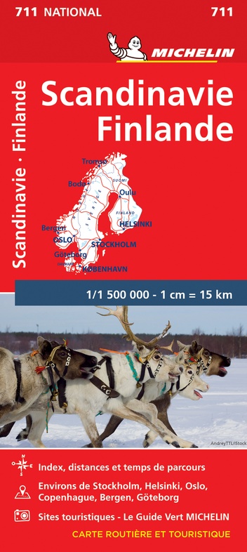
- Schaal: 1:1500000
- Uitgever: Michelin
- Soort: Wegenkaart
- Serie: National
- Taal: Engels, Frans
- Hoogte: 25.0 cm
- Breedte: 12.0 cm
- Gewicht: 115.0 g
- Bindwijze: -
- Uitvoering: Papier
- Beoordeling: 4,9 ★★★★★ (7 reviews) Schrijf een review
-
€ 13,95
Op voorraad
Op werkdagen vóór 17:00 besteld = dezelfde dag verzonden
Bezorging meestal binnen 1–2 werkdagen. Levertijd BelgieGratis verzending in Nederland vanaf €50,-
Beschrijving
Zoals je van Michelin mag verwachten is deze kaart zeer overzichtelijk en heeft een duidelijk helder kaartbeeld. De kaart geeft uitgebreid toeristische informatie weer. Natuurlijk vanwege het grote gebied een behoorlijk grove schaal.
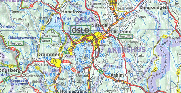
Scandinavia and Finland map at 1:1,500,000 from Michelin, including the whole of Denmark, Norway, and Sweden, with enlargements showing in greater detail road networks around Helsinki, the Copenhagen - Malmo area, Oslo, Bergen, Stockholm and Gothenburg.
Reviews
De kaart werd snel geleverd en in prima staat, Accurate en snelle levering en kwaliteit
★★★★★ door Ivan Crost 27 september 2023 | Heeft dit artikel gekochtVond u dit een nuttige review? (login om te beoordelen)
Prima kwaliteit en snelle levering.
★★★★★ door Jolien 1 mei 2023 | Heeft dit artikel gekochtVond u dit een nuttige review? (login om te beoordelen)
Ik gebruik hem deze keer als reis herinnering, ga het bewerken. Maar een mooie duidelijke kaart. Handig voor onderweg
★★★★★ door B. 29 maart 2023 | Heeft dit artikel gekochtVond u dit een nuttige review? (login om te beoordelen)
Schrijf een review
Graag horen wij wat u van dit artikel vindt. Vindt u het goed, leuk, mooi, slecht, lelijk, onbruikbaar of erg handig: schrijf gerust alles op! Het is niet alleen leuk om te doen maar u informeert andere klanten er ook nog mee!
Ook interessant voor europa/finland
-

Reisverhaal Boom in een winters bos
€ 24,99Reisverhalen Scandinavië -

Wandelkaart Terrängkartor Pohjois-Ka
€ 22,95Wandelkaarten Finland -

Reisgids Noorwegen | Mo'Media | Mome
€ 37,50Reisgidsen Noorwegen -

Campergids Europa | ANWB Media
€ 34,50Campergidsen De Alpen -

Wandelgids Die schönsten Wanderwege
€ 32,50Wandelgidsen Scandinavië