Categorieën
- Nieuwe artikelen
-
Boeken
- Aanwijswoordenboeken
- Accommodatiegidsen
- Atlassen
- Bed and Breakfast Gidsen
- Campergidsen
- Camperhandboeken
- Campinggidsen
- Duikgidsen
- Fietsatlassen
- Fietsgidsen
- Fotoboeken
- Historische Atlassen
- Kanogidsen
- Kinderatlassen
- Kinderreisgidsen
- Kleurboeken
- Klimgids - Klettersteiggidsen
- Kookboeken
- Mountainbikegidsen
- Natuurgidsen
- Pelgrimsroutes
- Reisboeken
- Reisdagboeken
- Reisfotografiegidsen
- Reisgidsen
- Reishandboeken
- Reisinspiratieboeken
- Reisverhalen
- Sneeuwschoenwandelgidsen
- Survivalgidsen
- Tourskigidsen
- Treinreisgidsen
- Vaargidsen
- Vogelgidsen
-
Wandelgidsen
- Afrika
- Azië
-
Europa
- Albanië
- Andorra
- Armenië
- België
- Bosnië - Hercegovina
- Bulgarije
- Cyprus
- Denemarken
- Duitsland
-
Engeland
- Noord Engeland
- North East England
- ♦ Northumberland National Park
- Yorkshire and the Humber
- ♦ Yorkshire Dales Nationaal Park
- ♦ North York Moors Nationaal Park
- North West England
- ♦ Isle of Man
- ♦ Lake District Nationaal Park
- ♦ North Pennines AONB
- 🥾 Hadrian's Wall Path
- Midden Engeland
- East Midlands
- West Midlands
- ♦ Cotswolds AONB
- ♦ Peak District Nationaal Park
- Wales
- ♦ Pembrokeshire Coast National Park
- ♦ Snowdonia Nationaal Park
- ♦ Brecon Beacons Nationaal Park
- East of England - East Anglia
- South West England
- ♦ Devon - Cornwall
- 🥾 South West Coast Path
- ♦ New Forrest National Park
- ♦ Dartmoor National Park
- South East England
- ♦ Kent
- ♦ South Downs Nationaal Park
- ♦ Isle of Wight
- Kanaaleilanden
- Londen
- Oxford
- Meer steden
- Estland
- Faroer
- Finland
- Frankrijk
- Georgië
- Griekenland
- Groenland
- Hongarije
- IJsland
- Ierland
- Italië
- Kosovo
- Kroatië
- Letland
- Liechtenstein
- Luxemburg
- Malta
- Montenegro
- Nederland
- Noord-Ierland
- Noord-Macedonië
- Noorwegen
- Oostenrijk
- Polen
- Portugal
- Roemenië
- Rusland
- Scandinavië
- Schotland
- Servië
- Slovenië
- Slowakije
- Spanje
- Tsjechië
- Turkije
- Zweden
- Zwitserland
- Midden-Amerika
- Midden-Oosten
- Noord-Amerika
- Oceanië
- Wereld
- Zuid-Amerika
- Werken en wonen in buitenland
- Woordenboeken & Taalgidsen
- Kaarten
- Opruiming
- Puzzels
- Travel Gadgets
- Wandkaarten
- Wereldbollen
Veilig online betalen
Betaal veilig via uw eigen bankomgeving
- U bent hier:
- Home
- Europa
- Engeland
- ♦ Yorkshire Dales Nationaal Park
- Boeken
- Wandelgidsen
Wandelgids Dales Way | Trailblazer Guides (9781912716302)
Ilkley to Bowness-on-Windermere
- ISBN / CODE: 9781912716302
- Editie: 2022
- Aantal blz.: 184
- Auteur(s): Henry Stedman
- Uitgever: Trailblazer Guides
- Soort: Wandelgids
- Taal: Engels
- Hoogte: 18.0 cm
- Breedte: 12.0 cm
- Dikte: 1.3 cm
- Gewicht (Gram): 184
- Bindwijze: Paperback
- Druk: 2
- Uitvoering: -
- Schrijf als eerste een review
-
€ 19,95
Leverbaar in 3 - 5 werkdagen in huis in Belgie Levertijd Nederland Leverbaar in 3 - 5 werkdagen in huis in Nederland Levertijd Belgie
Gratis verzending in Nederland vanaf €35,-
- Afbeeldingen
- Extra Info
- Inkijkexemplaar
Beschrijving
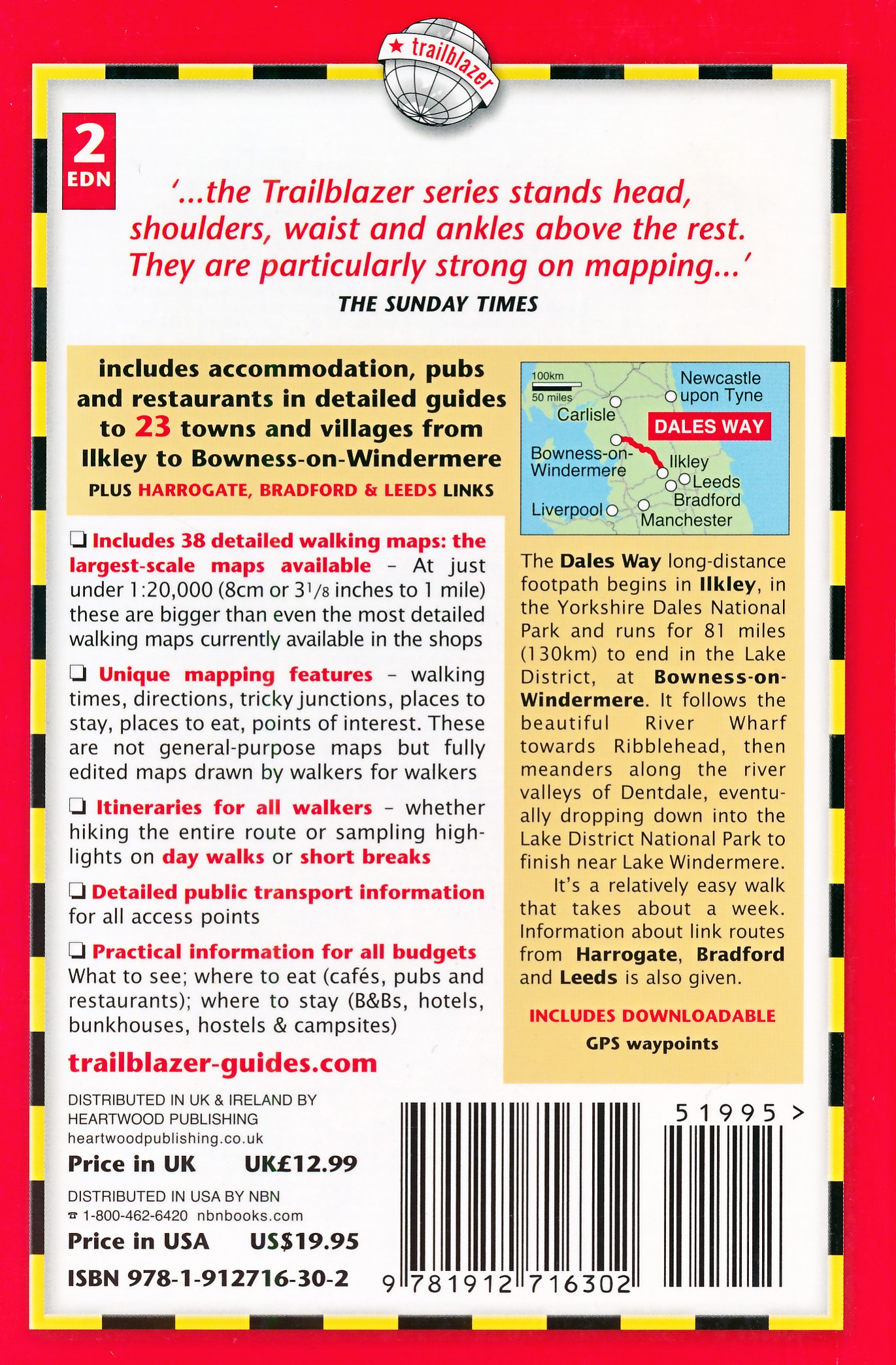
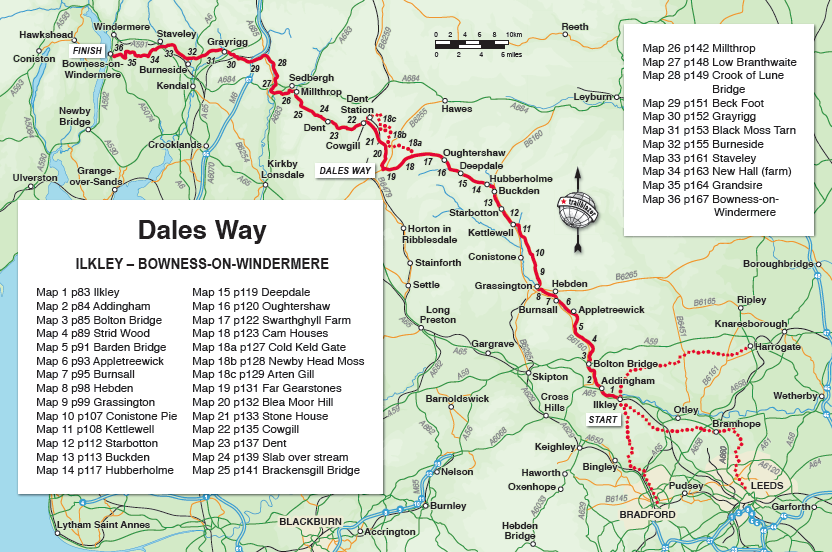
The popular Dales Way long-distance footpath begins in Ilkley, West Yorkshire and runs for 84 miles (135km) to end in the Lake District, in Bowness-on-Windermere. It follows riverside paths along the River Wharf towards Ribblehead and the watershed of northern England, then meanders along the river valleys of Dentdale, the River Mint and the River Kent dropping down into the Lake District to end beside Lake Windermere. It's a relatively easy walk that takes about a week.
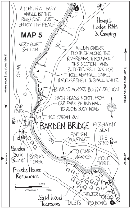
Includes 40 large-scale maps (3 1/8 inches to 1 mile); 9 town plans and 8 overview maps. Full details of all accommodations and campsites, restaurants and pubs; plus full public transport information. Plus day-walks. - 40 large-scale walking maps - at just under 1:20,000 - showing route times, places to stay, points of interest and much more - 9 town plans - 8 area maps and trail profiles - Itineraries for all walkers - whether walking the route in its entirety over a week or sampling the highlights on day walks and short breaks - Practical information for all budgets - camping, bunkhouses, hostels, B&Bs, pubs and hotels; Ilkley to Bowness-on-Windermere - where to stay, where to eat, what to see, plus detailed street plans - Comprehensive public transport information - for all access points on the Dales Way. - Flora and fauna - four page full color flower guide, plus an illustrated section on local wildlife - Green hiking - understanding the local environment and minimizing our impact on it - Includes downloadable gps waypoints
Reviews
Geen reviews gevonden voor dit product.
Schrijf een review
Graag horen wij wat u van dit artikel vindt. Vindt u het goed, leuk, mooi, slecht, lelijk, onbruikbaar of erg handig: schrijf gerust alles op! Het is niet alleen leuk om te doen maar u informeert andere klanten er ook nog mee!
Ook interessant voor europa/engeland/yorkshire-dales-nationaal-park
-
Fietskaart Reivers Cycle Routes | No
€ 16,50Fietskaarten North East England -
Wandelkaart - Topografische kaart 09
€ 14,95Topografische kaarten Noord Engeland -
Fietsgids Cycling in the Yorkshire D
€ 20,95Fietsgidsen Yorkshire and the Humber -
Wandelatlas The Dales Way Map Bookle
€ 10,50Wandelatlassen Noord Engeland -
Wandelgids Noord-Engeland | Uitgever
€ 18,99Wandelgidsen ♦ Yorkshire Dales Nationaal Park
TwitterVolg ons op twitter
Top! Ze zijn er weer: de gewijzigde verbeterde 1e druk van de Wandelknooppunten kaart Groningen. Verkrijgbaar in de… https://t.co/792C6fZX0n
3 maanden, 2 wekenZoek je leuk werk bij de Zwerver? Er is weer een vacature! Aarzel niet, ga er voor en versterk het geweldige Zwerve… https://t.co/we7lSAuegT
6 maanden, 1 weekBert Visscher in Groningen over zijn nieuwe boek “Italianen kunnen niks” https://t.co/8wy1HH4eI6 https://t.co/zMGH9w1DyG
8 maanden, 2 weken