Fietskaart Trans Pennine Trail Map 1 West Irish Sea to Yorkshire | Sustrans (9780953227778)
- ISBN / CODE: 9780953227778
- Schaal: 1:50000
- Uitgever: Sustrans
- Soort: Fietskaart
- Serie: Long Distance Cycle Route
- Taal: Engels
- Bindwijze: -
- Uitvoering: Papier
- Schrijf als eerste een review
-
€ 10,25
Uitverkocht, nooit meer leverbaar
Beschrijving
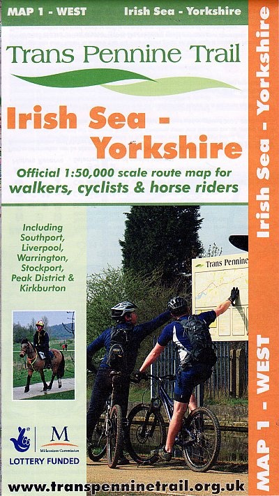
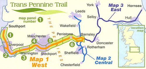
Double-sided waterproof map of the western part of the Trans Pennine Trail at 1:50,000, covering the Irish Sea to Yorkshire, ideal for walkers, cyclists and horse riders. This part of the trail goes includes Southport, Liverpool, Warrington, Stockport, and the Peak District. The route has been broken down into 6 panels, with colours and symbols clearly showing routes suited for cyclists, walkers, and horses; ‘danger points’, and types of crossing (pelican, puffin, etc.) prominently highlighted. Traffic-free paths and National Cycle Networks are also included with the route markings. Brief notes about the trail are shown in small boxes throughout, with distances given for each individual map panel.
As for the road network, motorways, dual carriageways, A and B roads are marked; railway lines and stops are displayed. Local facilities such as information centres, parking, pubs and cycle hire are indicated with a variety of symbols. There are no geographical coordinates for those using GPS.
The map includes an introduction to the trail and using it, as well as notes for horse riders, and travel information for the region.
Reviews
Geen reviews gevonden voor dit product.
Schrijf een review
Graag horen wij wat u van dit artikel vindt. Vindt u het goed, leuk, mooi, slecht, lelijk, onbruikbaar of erg handig: schrijf gerust alles op! Het is niet alleen leuk om te doen maar u informeert andere klanten er ook nog mee!
Ook interessant voor europa/engeland/west-midlands
-

Wandelgids 032 Pathfinder Short Walk
€ 11,95Wandelgidsen West Midlands -

Wandelkaart - Topografische kaart 13
€ 25,95Topografische kaarten West Midlands -

Wandelkaart - Topografische kaart 25
€ 19,95Topografische kaarten West Midlands -

Wandelgids 081 Pathfinder Guides Sta
€ 18,95Wandelgidsen West Midlands -

Wandelkaart - Topografische kaart 13
€ 19,95Topografische kaarten West Midlands