Winkelwagen
Geen items in winkelwagen
Ga naar winkelwagen
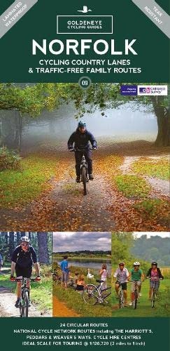
Fietskaart 09 Cycling guides Norfolk | Goldeneye (9781859652923)
cycling country lanes - traffic free family routes
- ISBN / CODE: 9781859652923
- Editie: 2022
- Schaal: 1:126720
- Uitgever: Goldeneye
- Soort: Fietskaart
- Serie: Cycling guides
- Taal: Engels
- Hoogte: 25.1 cm
- Breedte: 13.2 cm
- Dikte: 1.5 cm
- Bindwijze: -
- Uitvoering: Scheur- en watervast
- Schrijf als eerste een review
-
€ 14,95
Dit artikel is (tijdelijk) niet leverbaar
Beschrijving
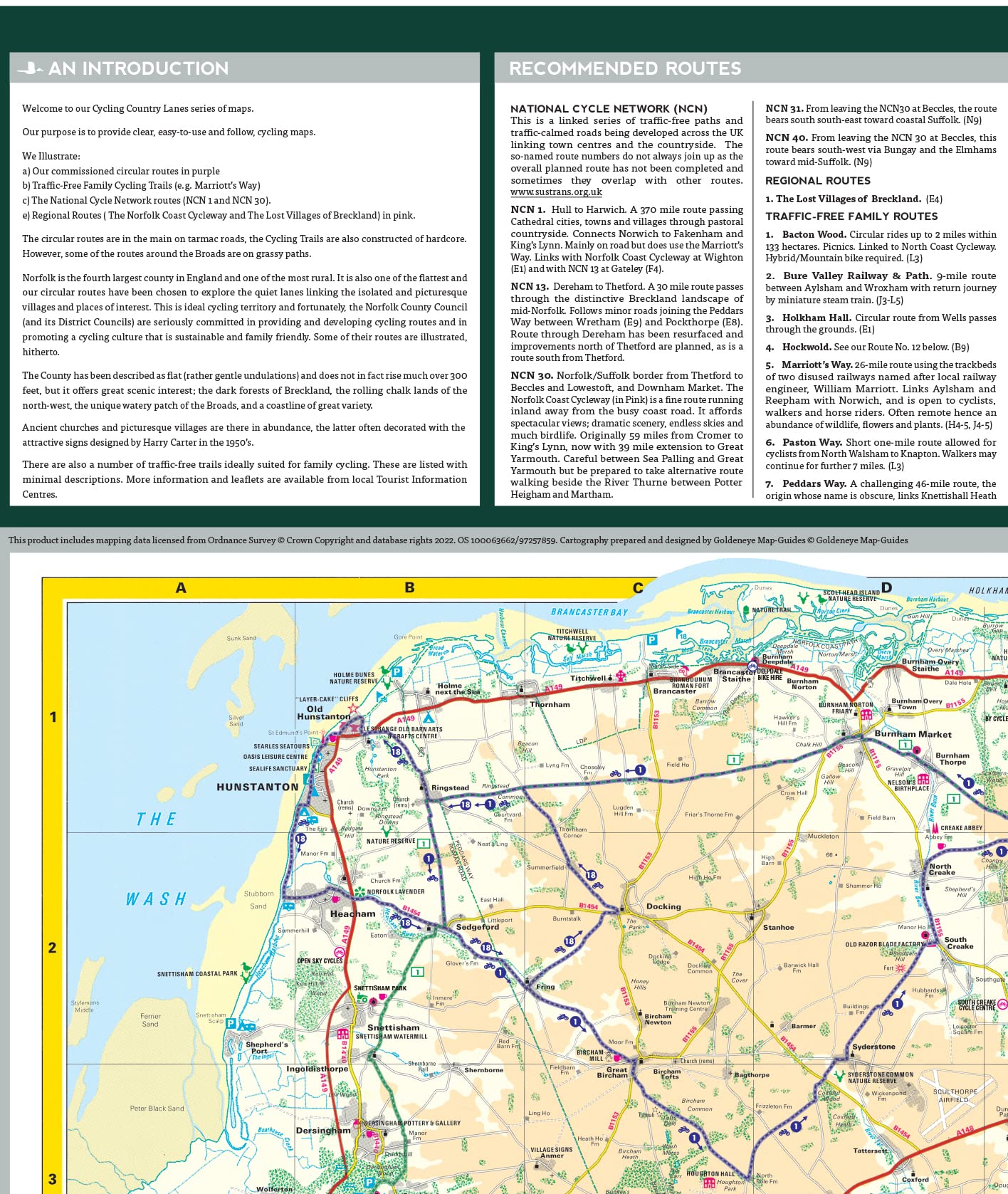
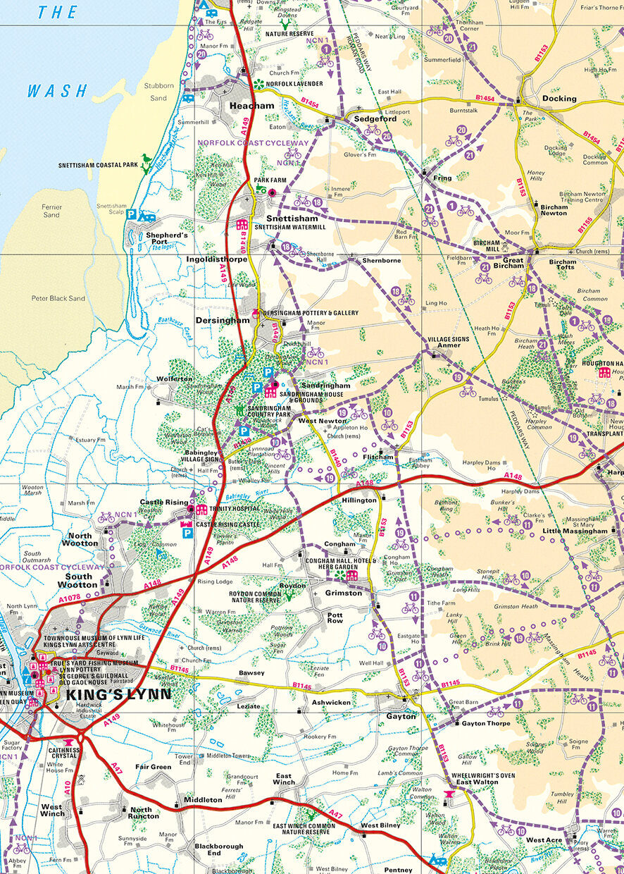
Norfolk is the fourth largest county in England and one of the most rural. It is also one of the flattest and our circular routes have been chosen to explore the quiet lanes linking the isolated and picturesque villages and places of interest. This is ideal cycling territory and fortunately, the Norfolk County Council (and its District Councils) are seriously committed in providing and developing cycling routes and in promoting a cycling culture that is sustainable and family friendly. Some of their routes are illustrated, hitherto.
The County has been described as flat (rather gentle undulations) and does not in fact rise much over 300 feet, but it offers great scenic interest; the dark forests of Breckland, the rolling chalk lands of the northwest, the unique watery patch of the Broads, and a coastline of great variety. Ancient churches and picturesque villages are there in abundance, the latter often decorated with the attractive signs designed by Harry Carter in the 1950’s.
Recommended Routes/Trails
National Cycle Network (NCN) & Regional Routes
This is a linked series of traffic-free paths and traffic-calmed roads being developed across the UK linking town centres and the countryside. The so-named route numbers do not always join up as the overall planned route has not been completed and sometimes they overlap with other routes. www.sustrans.org.uk
The following NCN routes cross Norfolk:-
NCN Route 1.
Hull to Harwich. A 370 mile route passing Cathedral cities, towns and villages through pastoral countryside. Connects Norwich to Fakenham and King’s Lynn. Mainly on road but does use the Marriott’s Way. Links with Norfolk Coast Cycleway at Wighton (E1) and with NCN 13 at Gateley (F4).
NCN Routes 13.
Dereham to Thetford. A 30 mile route passes through the distinctive Breckland landscape of mid-Norfolk. Follows minor roads joining the Peddars Way between Wretham (E9) and Pockthorpe (E8). Route through Dereham has been resurfaced and improvements north of Thetford are planned, as is a route south from Thetford.
Regional Routes
1. Norfolk Coast Cycleway NCN 30. A fine route running inland away from the busy coast road. It affords spectacular views; dramatic scenery, endless skies and much birdlife. Originally 59 miles from Cromer to King’s Lynn, now with 39 mile extension to Great Yarmouth. Careful between Sea Palling and Great Yarmouth but be prepared to take alternative route walking beside the River Thurne between Potter Heigham and Martham.
2. Regional Route 30. Norfolk/Suffolk border from Thetford to Beccles and Lowestoft, and Downham Market.
Traffic-Free Family Routes
1. Bacton Wood. Circular rides up to 2 miles within 133 hectares. Picnics. Linked to North Coast Cycleway. Hybrid/Mountain bike required. (L3)
2. Bure Valley Railway & Path. 9-mile route between Aylsham and Wroxham with return journey by miniature steam train. (J3-L5)
3. Holkham Hall. Circular route from Wells passes through the grounds. (E1)
4. Hockwold. See our Route No. 12 below. (B9)
5. Marriott’s Way. 26-mile route using the trackbeds of two disused railways named after local railway engineer, William Marriott. Links Aylsham and Reepham with Norwich, and is open to cyclists, walkers and horse riders. Often remote hence an abundance of wildlife, flowers and plants. (H4-5, J4-5)
6. Paston Way. Short one-mile route allowed for cyclists from North Walsham to Knapton. Walkers may continue for further 7 miles. (L3)
7. Peddars Way. A challenging 46-mile route, the origin whose name is obscure, links Knettishall Heath near Thetford with the coast at Holme. For the most part it follows the old Roman road built to restrain the rebellious Iceni tribe. Open to cyclists, walkers and horse riders. (F10-B1)
8. Quiet Lanes Project. See our route no.17. (L2)
9. Thetford Forest. Wide scope of off-road riding with links to Peddars Way. Bike hire at Forest High Lodge. (D9)
10. Weaver’s Way. 56-mile trail linking Cromer with Great Yarmouth by a circuitous route designed to cover a variety of scenery and places of interest using minor roads, footpaths and old railway lines. Named after weaving trade. Cycling only permitted on 13-mile section between Aylsham and Stalham. Surface often pitted. Short section of road through market town of North Walsham. (K3)
Reviews
Geen reviews gevonden voor dit product.
Schrijf een review
Graag horen wij wat u van dit artikel vindt. Vindt u het goed, leuk, mooi, slecht, lelijk, onbruikbaar of erg handig: schrijf gerust alles op! Het is niet alleen leuk om te doen maar u informeert andere klanten er ook nog mee!
Alle gerelateerde rubrieken >
Ook interessant voor europa/engeland/east-of-england-east-anglia
-

Wandelkaart - Topografische kaart 23
€ 20,95Topografische kaarten East Midlands -

Wandelkaart - Topografische kaart 23
€ 20,95Topografische kaarten East of England - East Anglia -

Wandelkaart - Topografische kaart 13
€ 20,95Topografische kaarten East of England - East Anglia -

Wandelkaart - Topografische kaart 22
€ 26,95Topografische kaarten East Midlands -

Wandelkaart 224 OS Explorer Map | Ac
€ 26,95Wandelkaarten East Midlands