National Geographic
Dit bekende tv-kanaal heeft naast prachtige natuurdocumontaires en magazines ook zijn eigen reisgidsen en wegenkaarten uitgegeven. De landkaarten zijn gedrukt op scheurvast en waterbestendig papier wat een vergrootte levensduur betekent. De kaarten zijn helder en bevatten een schat aan informatie voor zowel de 'gewone' toerist als de avonturier. De hoofdwegen zijn duidelijk aangegeven, maar ook de secundaire wegen en tracks staan er op. Met de nationale parken duidelijk en mooie zwemplekken of attracties aangegeven onderscheidt deze kaartenserie zich van de andere wegenkaarten. De kaarten heten dan ook niet voor niets Adventure Maps! Het avontuur wacht!
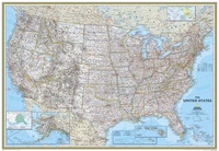 Magneetbord - Wandkaart USA - Verenigde Staten, politiek, 110 x 77 cm | National Geographic
Het klassieke kaartbeeld van National Geographic, de grenzen van de staten van Amerika zijn apart gekleurd. De wandkaart is heel gedetailleerd met veel plaatsen, wegen, rivieren en nationale parken, het …
 Wandkaart Europa, politiek & antiek, 249 x 194 cm | National Geographic
Deze kaart wordt gemaakt in drie delen - te groot om in 1 keer te fabriceren met kans op beschadigingen - die vervolgens zeer nauwkeurig aan elkaar worden geplakt. Daarna …
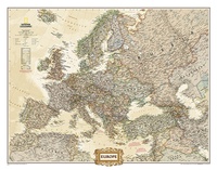
 Wandkaart Europa, politiek & antiek, 116 x 90 cm | National Geographic
National Geographic is a renowned authority in cartography. For 120 years the Society's maps have helped spread geographic knowledge around the globe. A vast database allows National Geographic to combine …
 Wandkaart Scandinavië en Ijsland, 60 x 77 cm | National Geographic
National Geographic Wall Maps offer a special glimpse into current and historical events, and they inform about the world and environment. Offered in a variety of styles and formats, these …
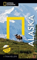 Reisgids Alaska | National Geographic
National Geographic Traveler: Alaska is the travel partner you need to organize a visit to the boundless uncontaminated spaces of "the Great Land" of Alaska, the largest American state, where …
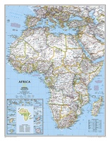 Magneetbord Afrika, politiek, 91 x 118 cm | National Geographic
Mooie wandkaart van Afrika, staatkundig, met rustig kleurgebruik en helder kaartbeeld, Ondanks het wat kleiner formaat staan er toch heel wat topografische details op vermeld. The map presents Africa …
 Magneetbord Afrika, politiek, 61 x 78 cm | National Geographic
Mooie wandkaart van Afrika, staatkundig, met rustig kleurgebruik en helder kaartbeeld, Ondanks het wat kleiner formaat staan er toch heel wat topografische details op vermeld. Kaart is up-to-date, alleen …
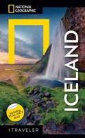 Reisgids IJsland - Iceland | National Geographic
National Geographic Traveler: Iceland is the lighthouse to follow if you do not want to miss anything of the unique and incredible atmosphere, from the northern lights to the capital, …
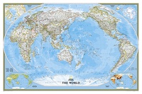 Wereldkaart Politiek, pacific centered, 117 x 78 cm | National Geographic
This unique view employs a new map projection to accentuate the Pacific Rim, and shows Oceania and Asia in close proportion to their actual size on the Earth. It brings …
★★★★★ Wandkaart Costa Rica, 97 x 92 cm | National Geographic
Decoratieve wandkaart van Costa Rica. Naast de mooie kleuren staan er bijzonder veel plaatsen op vermeld. This full-color map is a richly detailed rendering of one of Central America's greatest …
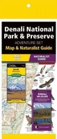 Natuurgids Adventure Set Denali National Park & Preserve | National Geographic
Handige combinatie van een uitstekende wegenkaart van National Geographic en de uitklapkaart van natuur van uitgever Waterford. National Geographic: Zeer gedetailleerde kaart. Misschien wel de beste kaart! Gedrukt op …
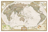 Wereldkaart Politiek & antiek, pacific centered, 117 x 78 cm | National Geographic
National Geographic's World map is the standard by which all other reference maps are measured. The World map is meticulously researched and adheres to National Geographic's convention of making independent, …
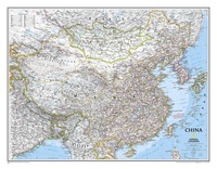 Wandkaart China, 76 x 59 cm | National Geographic
Decoratieve wandkaart van China. Naast de mooie kleuren staan er bijzonder veel plaatsen op vermeld. Het gaat soms een beetje ten kosten van de schoonheid van de kaart, maar daardoor …
★★★★★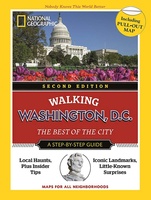 Wandelgids Walking Washington D.C. | National Geographic
Discover the best of Washington, D.C. with this handy guide, through 13 itineraries with step-by-step maps to help you explore its lively, eclectic neighborhoods. In a practical pocket format, the …
 Wandkaart Antarctica Satellite Map, 78 x 50 cm | National Geographic
This digital mosaic of 4,500 satellite scans shows incredible detail of Antarctica's terrain. Includes insets that show the surface elevation, ice sheet thickness, ice flow velocity, and sea ice movement …
★★★★★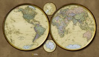 Historische wereldkaart World hemispheres, politiek, 107 x 62 cm | National Geographic
During the 1930s and 1940s, National Geographic designed several world maps using a projection that separated the eastern and western hemispheres. We have brought back this classic view of the …
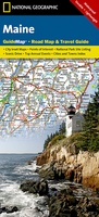 Wegenkaart - landkaart State Guide Map Maine | National Geographic
Makkelijk leesbare kaart aan 2 zijden bedrukt. De ene kan met informatie en beperkte stadsplattegronden, de andere met de daadwerkelijke kaart. De kaart is geplastificeerd en dus watervast! The front …
★★★★★ Wegenkaart - landkaart State Guide Map Massachusetts | National Geographic
Makkelijk leesbare kaart aan 2 zijden bedrukt. De ene kan met informatie en beperkte stadsplattegronden, de andere met de daadwerkelijke kaart. De kaart is geplastificeerd en dus watervast! The front …
 Wandkaart Centraal Amerika, 73 x 55 cm | National Geographic
This Central America Wall Map by National Geographic contains extensive political information with political boundaries clearly presented with different color-bands for each country. Beautifully shaded to show physical terrain, this …
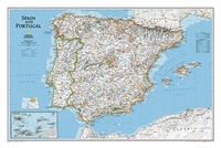 Wandkaart Spain - Spanje & Portugal, 83 x 55 cm | National Geographic
This classic-style map of Spain and Portugal shows political boundaries, major highways and roads, cities and towns, airports and other geographic details. Thousands of place-names and exact borders are carefully …
Laatste reviews

Prachtige wandelgids voorzien van alle voor de wandelaars benodigde informatie (accommodaties, restaurants en cafés, vervoersmogelijkheden enz.). Ook is de gids beschreven in twee richtingen en …
★★★★★ door Mathie Hoenjet 27 juni 2026 | Heeft dit artikel gekocht
Zoals altijd duidelijke en overzichtelijke kaart van Michelin
★★★★★ door Charles Trippelvitz 26 juni 2026 | Heeft dit artikel gekocht
Door deze gids konden we ons heel goed voorbereiden op onze fietstocht. En het gebruik onderweg was ook prima. Jammer dat de campings onderweg wat …
★★★★★ door Helma Feenstra 26 juni 2026 | Heeft dit artikel gekocht
Kort voor vakantie naar de Galapagos eilanden toch nog behoefte aan extra reisgids. Simpel kunnen bestellen en snelle levering. Zou niet weten wat er beter …
★★★★★ door Piet Grootenboer 25 juni 2026 | Heeft dit artikel gekocht