Collins
Maak je reis compleet met de handige reisgidsen en wegenkaarten van Collins
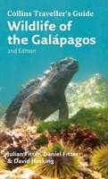 Natuurgids Wildlife of the Galapagos | Collins
Since its first publication more than a decade ago, Wildlife of the Galápagos has become the definitive, classic field guide to the natural splendors of this amazing part of the …
★★★★★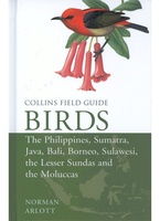 Vogelgids Birds of the Philippines, Sumatra, Java, Bali, Borneo, Sulawesi, the Lesser Sundas and the Moluccas | Collins
This comprehensive new field guide is an excellent addition to the world-renowned series – the ultimate reference book for travelling birdwatchers. Every species of bird you might encounter in …
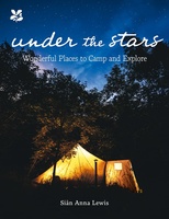 Campinggids Under the Stars | Collins
Inspiring and exciting places to camp and glamp in Britain A camping trip is the perfect antidote to fast-paced living, a chance to watch stars emerge one by one, …
 Wegenkaart - landkaart National Park Pocket Map New Forest | Collins
Handige kleine kaart van dit Nationaal Park. De kaart geeft een goed en helder overzicht van het gebied met alle plaatsen, doorgaande wandelpaden (alhoewel grof van schaal), bezienswaardigheden etc. Met …
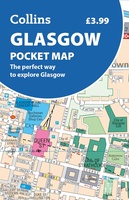 Stadsplattegrond Pocket Map Glasgow | Collins
 World Atlas Essential | Collins
 Wegenkaart - landkaart National Park Pocket Map Dartmoor | Collins
Handige kleine kaart van dit Nationaal Park. De kaart geeft een goed en helder overzicht van het gebied met alle plaatsen, doorgaande wandelpaden (alhoewel grof van schaal), bezienswaardigheden etc. Met …
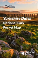 Wegenkaart - landkaart National Park Pocket Map Yorkshire Dales | Collins
Handige kleine kaart van dit Nationaal Park. De kaart geeft een goed en helder overzicht van het gebied met alle plaatsen, doorgaande wandelpaden (alhoewel grof van schaal), bezienswaardigheden etc. Met …
★★★★★ Wegenatlas Collins Handy Road Atlas Scotland | A5-Formaat | Collins
Discover new places with handy road atlases from Collins. Your ideal companion for navigating around Scotland. It has extremely clear, route planning maps of Scotland, detailed city plans of the …
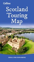 Wegenkaart - landkaart Touring Map of Scotland - Schotland | Collins
Best-selling map of Scotland. More than 1,000 places of tourist interest plotted and named on the map. The features have been plotted onto an up-to-date and attractive Collins map of …
★★★★★★★★★★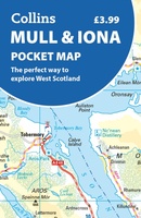 Wegenkaart - landkaart Pocket Map Mull and Iona | Collins
Explore new places with handy pocket maps from Collins. Handy little full colour map showing the islands of Mull and Iona. Excellent value and very detailed for its size. …
 Wandelgids Park Rangers Favourite Walks Snowdonia | Collins
Compacte wandelgids met 20 wandelingen geselecteerd door park rangers en met duidelijke beschrijvingen en routekaartjes. Walking guide to the Snowdonia National Park, with 20 best routes chosen by the …
 Stadsplattegrond Discovering Edinburgh Illustrated Map | Collins
Explore new places with dependable maps from Collins. This brand new edition retains the delightful water-colour mapping, with individual paintings of all the main sights and landmarks. This brand …
★★★★★ Wegenatlas Europe road map | Collins
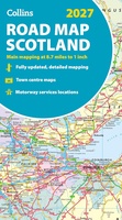 Wegenkaart - landkaart Scotland road map 2027 | Collins
 Spoorwegenkaart Japan Rail Map | Collins
Looking for your next adventure? This rail map of Japan is the perfect planning and travel companion "This map combines clear, understandable cartography with practical tips and information, making it …
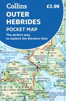 Wegenkaart - landkaart Pocket Map Outer Hebrides | Collins
Explore new places with handy pocket maps from Collins. Handy little full-colour map of the Western Isles of Scotland. Detailed mapping and tourist information for the islands of Lewis, Harris, …
★★★★★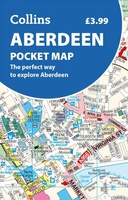 Stadsplattegrond Aberdeen pocket map | Collins
 Wegenkaart - landkaart National Park Pocket Map North York Moors | Collins
Handige kleine kaart van dit Nationaal Park. De kaart geeft een goed en helder overzicht van het gebied met alle plaatsen, doorgaande wandelpaden (alhoewel grof van schaal), bezienswaardigheden etc. Met …
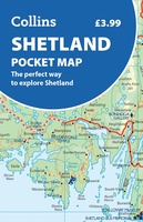 Wegenkaart - landkaart Pocket Map Shetland pocket map | Collins
Discover new places with handy pocket maps from Collins. The Shetland Islands, Scotland’s northernmost archipelago, are famous for their wild beauty, rich Viking heritage, and dramatic coastal scenery. With …
- 1
- 2
- 3
- Volgende >>
- 7
Laatste reviews

Uitstekend
★★★★★ door Nelly van Ginkel 24 juli 2026 | Heeft dit artikel gekocht
Fijne kaart waterafstootend.
★★★★★ door Nicole 21 juli 2026 | Heeft dit artikel gekocht
Mooie helder kaart, netjes bezorgd
★★★★★ door Michael Rijke 21 juli 2026 | Heeft dit artikel gekocht
Fijne wandelkaart, gedetailleerd en met veel extra info. Super fijn om m voor onze vakantie al te kunnen kopen, zo kon de voorpret al beginnen …
★★★★★ door Wille Groenewolt 21 juli 2026 | Heeft dit artikel gekocht