Wandkaarten van landen
Wandkaart van de wereld kopen? Laat uw interieur de grenzen verleggen met onze collectie landkaarten
Heeft u een speciale band met een bepaald land of vindt u de vorm van Groot-Brittannië gewoon erg mooi bij uw interieur staan? Er zijn landkaarten van veel verschillende landen: van Alaska tot Australië. De meeste zijn zeer gedetailleerd en geven steden, wateren, bergruggen en grenzen aan, sommige geven slechts lijnen en kunt u zelf inkleuren.
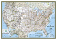 Wandkaart 02003 USA - Verenigde Staten Political, 110 x 77 cm | National Geographic
Het klassieke kaartbeeld van National Geographic, de grenzen van de staten van Amerika zijn apart gekleurd. De wandkaart is heel gedetailleerd met veel plaatsen, wegen, rivieren en nationale parken, het …
★★★★★ Wandkaart 02008 USA - Verenigde Staten Political, 178 x 124 cm | National Geographic
Het klassieke kaartbeeld van National Geographic, de grenzen van de staten van Amerika zijn apart gekleurd. De wandkaart is heel gedetailleerd met veel plaatsen, wegen, rivieren en nationale parken, het …
★★★★★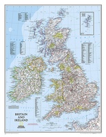 Wandkaart 02022 Britain and Ireland - Groot Brittannië en Ierland, 60 x 76 cm | National Geographic
This classic-style map of England and Wales shows political boundaries, major highways and roads, cities and towns, airports, and other geographic details. Thousands of place-names and exact borders are carefully …
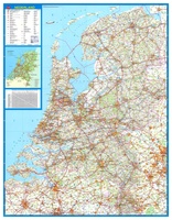 Wandkaart 34 Nederland Basic, 100 x 130 cm | Falk
Wandkaart - Falk Nederland met een formaat van 130 (h) X 100 (b) cm. Het is een zeer gedetailleerde en duidelijke wandkaart, met veel plaatsen, wegen met wegnummers, afritten. Deze …
★★★★★ Wandkaart 22111 Greece – Griekenland, 77 x 60 cm | National Geographic
Decoratieve wandkaart van Griekenland. Naast de mooie kleuren staan er bijzonder veel plaatsen op vermeld. The classic National Geographic wall map of Greece shows this beautiful area in uncompromisingly …
 Wandkaart 20002 Australië, politiek, 77 x 69 cm | National Geographic
Highly accurate Australia political map clearly shows state boundaries, place names, bodies of water, parks and preserves, and more. Includes inset maps for Tasmania and major Australian cities.
★★★★★ Wandkaart 20044 Holy Land – Israël, 53 x 80 cm | National Geographic
National Geographic Wall Maps offer a special glimpse into current and historical events, and they inform about the world and environment. Offered in a variety of styles and formats, these …
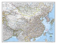 Wandkaart 20057 China, 76 x 59 cm | National Geographic
Decoratieve wandkaart van China. Naast de mooie kleuren staan er bijzonder veel plaatsen op vermeld. Het gaat soms een beetje ten kosten van de schoonheid van de kaart, maar daardoor …
★★★★★ Wandkaart 20114 USA - Verenigde Staten politiek, antiek, 108 x 75 cm | National Geographic
Wandkaart van de USA waarbij de kleuren in 'antieke' look zijn weergegeven, de staatgrenzen zeer duidelijk zijn en er veel plaatsen op staan. This Antique-style USA Wall Map by National …
★★★★★★★★★★ Wandkaart 20115 USA United States Executive Antique Large | 176 x 122 cm | National Geographic
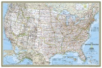 Wandkaart 20383 USA - Verenigde Staten Political, 91 x 61 cm | National Geographic
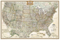 Wandkaart 20386 USA politiek antiek | Papier | 92 x 61 cm | National Geographic
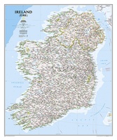 Wandkaart 20427 Ireland – Ierland, 76 x 91 cm | National Geographic
National Geographic Maps' new Ireland wall map is one of the most authoritative maps yet published of the Emerald Isle. Of the nearly 1,000 place-names shown on this map, all …
 Wandkaart 20436 Afghanistan & Pakistan, 55 x 83 cm | National Geographic
This is the latest and most detailed map of the region - a perfect complement for following today's news stories. Afghanistan's 34 administrative provinces and Pakistan's provinces and territorial boundaries …
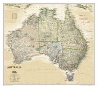 Wandkaart 20439 Australië, politiek & antiek, 77 x 69 cm | National Geographic
A current political map of Australia in rich, earth-toned colors clearly shows state boundaries, place names, bodies of water, parks and preserves, and more. Includes inset maps for Tasmania and …
 Wandkaart 20527 Canada, 97 x 82 cm | National Geographic
Decoratieve wandkaart van Canada. Naast de mooie kleuren staan er bijzonder veel plaatsen op vermeld. This beautiful wall-map from National Geographic depicts Canada and the areas surrounding the Great Lakes …
 Wandkaart 20530 Canada, antiek, 97 x 82 cm | National Geographic
Our most detailed wall map of Canada, features the classic National Geographic reference styling. Features thousands of place names, accurate political boundaries, national parks, archeological sites, and major infrastructure networks …
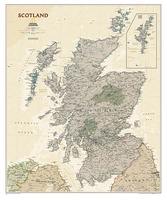
 Wandkaart 20533 Schotland, 76 x 91 cm | National Geographic
This new map of Scotland, features our rich, antique-inspired Executive style. This beautiful map includes thousands of place names, accurate political boundaries, national parks, archeological sites, and major infrastructure networks …
★★★★★ Wandkaart 20536 Schotland antiek | 76 x 91 cm | National Geographic
 Wandkaart 20546 India, 60 x 77 cm | National Geographic
See India as only National Geographic can depict it. This new reference map is one of the most detailed and comprehensive ever published for India and southern Asia. It includes …
- 1
- 2
- 3
- Volgende >>
- 5
Waar moet je op letten als je een goede wandkaart van een land wilt kopen?
Welke verschillende soorten wandkaarten van landen zijn er eigenlijk: het kaartbeeld?
Verschillende projecties, hoe zit een wandkaart er uit?
Zijn er wandkaarten van alle landen beschikbaar?
Het formaat van een wandkaart van een land
De leesbaarheid van een wandkaart van een land
Veel uitvoeringen van dezelfde wandkaart van een land
Hoe wordt de wandkaart verzonden?
Laatste reviews

Ben nog niet het veld in geweest met de gids maar de eerste indruk is veel informatie om een meerdaagse tocht uit te stippelen.
★★★★★ door Henk 04 juli 2026 | Heeft dit artikel gekocht
Prima in orde!
★★★★★ door Marko 04 juli 2026 | Heeft dit artikel gekocht
Fijn boekje met veel informatie, behalve knooppunten Utrecht af en toe incorrect. Wat heerlijk om offline te navigeren, lekker analoog. Zodra je het systeem begrijpt …
★★★★★ door Daan 03 juli 2026 | Heeft dit artikel gekocht
Als je van geschiedenis, Groningen en kaarteen houdt, is dit echt een aanrader!
★★★★★ door Reinout 03 juli 2026 | Heeft dit artikel gekocht