Wegenatlas - Atlas New Zealand Road Atlas (Nieuw Zeeland) | Hema Maps (9781877302640)

- ISBN / CODE: 9781877302640
- Editie: 2010
- Schaal: 1:300000
- Uitgever: Hema Maps
- Soort: Atlas, Wegenatlas
- Taal: Engels
- Schrijf als eerste een review
-
€ 27,50
Uitverkocht, nooit meer leverbaar
Beschrijving
Groot formaat (B4) wegenatlas van Nieuw Zeeland met spiraalbinding. Met mooie duidelijke heldere kaarten.
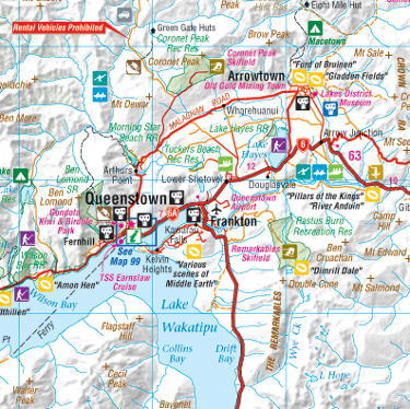
New Zealand Road Atlas, large format, spiral-bound, paperback version of Hema’s New Zealand Touring Atlas, with the same content reproduced at a larger size for clarity. Here the road mapping scale is approx. 1:300,000, with additional maps and information on eight national parks, plus street plans and suburban area maps. Motorhome dump stations are listed and a table shows Dept. of Conservation campsites and their respective visitor facilities e.g. toilets, showers and rubbish disposal.
Road detail includes minor roads and tracks, and distinguishes unsurfaced routes, with intermediate driving distances marked for main roads. Symbols identify several national Tourist Routes and the existing sections of the Te Araroa Trail are marked. Main railways, airports and airfields are marked. Some hill shading shows the general relief and significant mountain peaks are indicated, while colours highlight national parks, reserves, forest parks and marine reserves. Symbols represent a range of tourist features e.g. caravan and camping sites, dump stations, information centres, roadside rest areas, places of interest, LOTR movie set locations, and many recreational sites such as bungy-jumping and dolphin watching locations. For GPS users, New Zealand Map Grid lines are drawn over the road mapping.
Travelling time/distance tables for main routes on each island are provided, also an introductory section on recommended attractions and activities. The information on a selection of national parks provides a brief introduction to their attractions; the maps do not present any extra detail, but show a convenient overview of each park on one page. A collection of 48 city centre and suburb maps for towns and cities follow the main road atlas pages. The street maps show one-way streets, notable buildings, places of interest and useful facilities e.g. post offices, accommodation, shopping areas and hospitals. The less detailed suburban maps show the main communications and name many roads and districts.
Reviews
Geen reviews gevonden voor dit product.
Schrijf een review
Graag horen wij wat u van dit artikel vindt. Vindt u het goed, leuk, mooi, slecht, lelijk, onbruikbaar of erg handig: schrijf gerust alles op! Het is niet alleen leuk om te doen maar u informeert andere klanten er ook nog mee!
Ook interessant voor oceanie/nieuw-zeeland
-

Natuurgids New Zealand wildlife | Wa
€ 10,95Natuurgidsen Nieuw Zeeland -

Reisgids New Zealand - Nieuw Zeeland
€ 27,95Reisgidsen Nieuw Zeeland -

Vogelgids a Naturalist's guide to th
€ 18,50Vogelgidsen Nieuw Zeeland -

Wandelgids Neuseeland - Nieuw Zeelan
€ 26,95Wandelgidsen Nieuw Zeeland -

Stadsplattegrond Wellington | Freyta
€ 13,95Stadsplattegronden Wellington