Wandelkaart Sierra de Grazalema (Parque Natural) e-25 | Editorial Alpina (9788480901833)
- ISBN / CODE: 9788480901833
- Schaal: 1:25000
- Uitgever: Editorial Alpina
- Soort: Wandelkaart
- Taal: Engels
- Schrijf als eerste een review
-
€ 16,95
Uitverkocht, nooit meer leverbaar
.jpg)
Beschrijving
Zeer gedetailleerde wandelkaart van de Sierra de Grazalema. Met ingetekende wandelroutes en andere informatie. uitstekende kaart. Met symbolen voor campings, hutten.
Let op: deze uitgever is traag met het vernieuwen van kaarten; het kan zo maar zijn dat een bepaalde kaart gedurende langere tijd niet beschikbaar is.
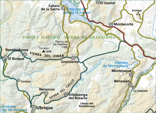
Sierra de Grazalema in an extensive and very popular series of walking maps from Editorial Alpina covering the Pyrenees, Catalonia and other selected hiking areas in Spain, including Picos de Europa, Sierra Nevada and parts of Andalucía, Majorca, etc. Scales vary from 1:50,000 to 1:10,000, with the majority of the titles at 1:25,000. The maps have contours, usually at 20m or 10m intervals, with additional hill shading and spot heights. An overprint highlights hiking trails, long-distance footpaths, campsites, mountain huts, refuges, etc. Many maps also show climbing sites, potholing caves, mountain bike routes, equestrian and ski centres.
All the latest editions have a UTM grid, plus margin ticks for latitude and longitude at intervals of 1’. Map legend in most titles includes English.
Each title has a separate booklet with general information on the area, descriptions of selected hiking routes, a list of accommodation with addresses, etc. In several titles the booklet now includes English.
In this title: Contours at 10m intervals, relief shading and vegetation colouring. UTM grid and 1’ margin ticks. In addition to the footpaths, the overprint shows various types of accommodation (hotels, youth hostels, campsites), information centres, places of interest, paragliding sites, locations of petrol stations in the local villages and on approach roads, etc. Map legend and the booklet with descriptions of the area and various hiking routes include English.
• Hiking map and guidebook
• Scale 1:25.000
• Equidistance contours: 10 m distance
• Master contours: at 50 m
• Shady relief
• Land use symbolized at three levels
• UTM grid with divisions of 1 km
• Compatible with GPS
• Marked routes
• Guidebook with hikes, potholing, gully descent, climbing, mountain biking and all the facts of interest
Reviews
Geen reviews gevonden voor dit product.
Schrijf een review
Graag horen wij wat u van dit artikel vindt. Vindt u het goed, leuk, mooi, slecht, lelijk, onbruikbaar of erg handig: schrijf gerust alles op! Het is niet alleen leuk om te doen maar u informeert andere klanten er ook nog mee!
Ook interessant voor europa/spanje/andalusie
-

Reisgids Eyewitness Top 10 Andalucia
€ 13,95Reisgidsen Andalusië - Zuid Spanje -

Reisverhaal De tribune van de armen
€ 22,90Reisverhalen Andalusië - Zuid Spanje -

Wandelgids 291 Via de la Plata | Rot
€ 17,95Wandelgidsen Noordwest Spanje - Galicië - Asturië -

Wegenkaart - landkaart - Wandelkaart
€ 12,95Wandelkaarten Andalusië - Zuid Spanje -

Campergids Camper Guide Spanien: Mit
€ 22,50Campergidsen Catalonië