Mandje Tel: +31503126950 Menu
Winkelwagen
Geen items in winkelwagen
Ga naar winkelwagen

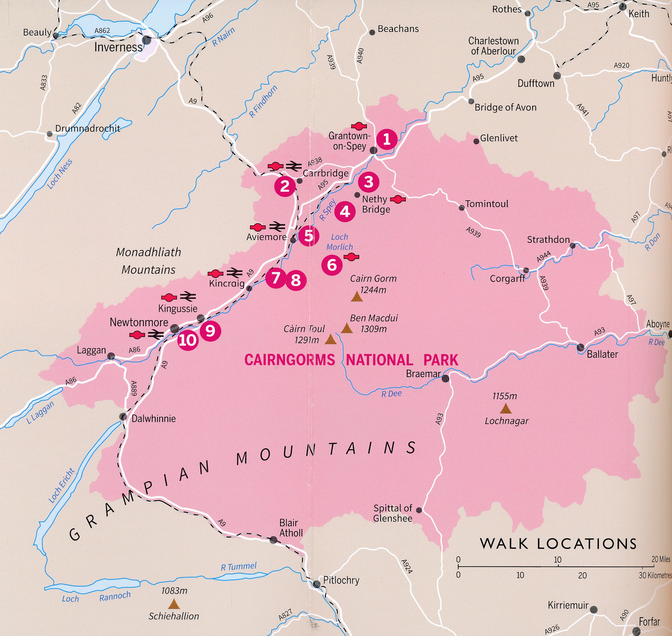
Wandelgids Aviemore and the Cairngorms | Ordnance Survey (9780319092293)

10 Leisurely Walks

  • ISBN / CODE: 9780319092293
  • Editie: 04-04-2022
  • Aantal blz.: 80
  • Uitgever: Ordnance Survey
  • Soort: Wandelgids
  • Serie: Short Walks Made Easy
  • Taal: Engels
  • Hoogte: 23.0 cm
  • Breedte: 13.0 cm
  • Gewicht: 164.0 g
  • Uitvoering: -
  • Bindwijze: Paperback
  • Beoordeling: 5,0 ★★★★★ (1 review) Schrijf een review
  • 10,00

    Op voorraad. Binnen 2 - 3 werkdagen in huis in Belgie Levertijd Nederland Voor 17.00 uur op werkdagen besteld, morgen in huis in Nederland Levertijd Belgie

    Gratis verzending in Nederland vanaf €35,-

Beschrijving

Get outside in the Cairngorms, Britain’s largest national park, with ten tried-and-tested accessible walks along the Spey Valley. Discover ancient Caledonian woodland, beautiful lochs and sparkling rivers against a backdrop of snow-capped mountains, waiting for the whole family to enjoy.
 
Aviemore and the Cairngorms Short Walks Made Easy include:
 
- Explore Loch Garten and Loch Mallachie, an RSPB Reserve and a haven for ospreys, and pine woodland filled with rare wildlife
- Follow the line of the Strathspey Railway and see steam trains chugging past from Aviemore to the ‘osprey village’ of Boat of Garten
- Go for a woodland ramble through Glenmore Forest Park to glacial Loch Morlich, where you can stroll the red sands of the highest beach in Britain
- Wander the enchanted shores of Loch an Eileen, where a ruined castle stands on the loch’s one island
- Stroll through wildflower-rich meadows on the banks of the Calder and the Spey as you circle Newtonmore
- See the iconic Old Packhorse Bridge amidst glorious pinewoods at Carrbridge
 
Short Walks Made Easy guidebooks:
 
- A six-book series: Lake District, Peak District, South Downs, Aviemore and the Cairngorms, Northumberland and Snowdonia
- 10 accessible walks suitable for the whole family
- All routes are between 2 to 5 miles and can be completed all year round
- Know what to expect before you go: Information on locations of cafes/pubs and toilets, terrain, hilliness and accessibility for pushchairs and wheelchairs
- Large-scale Ordnance Survey maps for ultra-easy navigation and route-finding, featuring intuitive pictorial symbols
- Numbered points which tie maps to route descriptions and walk profiles
- Route photographs for each numbered point so you know exactly where you’re going
- Enhance your adventure with stories behind each walk and nature notes
- Get active outside and enjoy the physical and mental health benefits

Reviews

Informatief boekje voor kleine wandelingen

Mooi uitgevoerd en fijn. Bij elke wandeling niet alleen een kaartje en routebeschrijving, maar ook achtergrondinformatie en informatie over de natuur. Bevat dus echt korte wandelingen - voor ons ideaal.

★★★★★ door Arjan de Jong 15 januari 2026 | Heeft dit artikel gekocht

Vond u dit een nuttige review? (login om te beoordelen)

-
Nee (0)

Schrijf een review

Graag horen wij wat u van dit artikel vindt. Vindt u het goed, leuk, mooi, slecht, lelijk, onbruikbaar of erg handig: schrijf gerust alles op! Het is niet alleen leuk om te doen maar u informeert andere klanten er ook nog mee!