Wandelkaart Pennine Way Central | Harvey Maps (9781851375202)
Horton in Ribblesdale to Greenhead
- ISBN / CODE: 9781851375202
- Schaal: 1:4000000
- Uitgever: Harvey Maps
- Soort: Wandelkaart
- Serie: National Trail Maps
- Taal: Engels
- Uitvoering: Geplastificeerd
- Schrijf als eerste een review
-
€ 21,50
Uitverkocht, nooit meer leverbaar
-
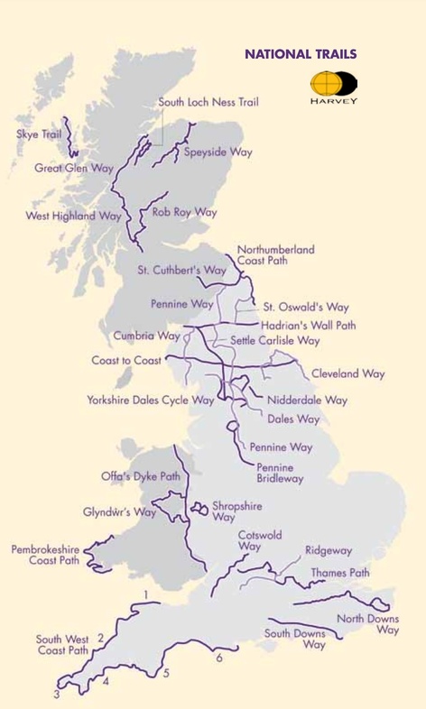
Overzicht National Trail Maps Harvey Maps


Producten op deze overzichtskaart:
Klik op een product om naar de pagina van dat product te gaan.
- Wandelkaart 1 South West Coast Path 1 | Harvey Maps
- Wandelkaart 3 South West Coast Path 3 | Harvey Maps
- Wandelkaart Affric Kintail Way | Harvey Maps
- Wandelkaart Anglesey Coastal Path | Harvey Maps
- Wandelkaart Beacons Way XT40 | Harvey Maps
- Wandelkaart Cambrian Way North XT40 | Harvey Maps
- Wandelkaart Cape Wrath Trail North | Harvey Maps
- Wandelkaart Cape Wrath Trail South | Harvey Maps
- Wandelkaart Cleveland Way | Harvey Maps
- Wandelkaart Coast to Coast | Harvey Maps
- Wandelkaart Cotswold Way | Harvey Maps
- Wandelkaart Cumbria Way | Harvey Maps
- Wandelkaart Cumbria Way South XT40 | Harvey Maps
- Wandelkaart Dales Way | Harvey Maps
- Wandelkaart East Highland Way | Harvey Maps
- Wandelkaart Fife Coastal Path | Harvey Maps
- Wandelkaart Glyndwr's Way | Harvey Maps
- Wandelkaart Great Glen Way | Harvey Maps
- Wandelkaart Hadrian's Wall | Harvey Maps
- Wandelkaart John O'Groats trail | Harvey Maps
- Wandelkaart North Downs Way | Harvey Maps
- Wandelkaart Northumberland Coast Path and Berwickshire Coastal Path | Harvey Maps
- Wandelkaart Offa's Dyke Path | Harvey Maps
- Wandelkaart Peddars Way & Norfolk Coast Path | Harvey Maps
- Wandelkaart Pennine Bridleway | Harvey Maps
- Wandelkaart Pennine Way North | Harvey Maps
- Wandelkaart Pennine Way South | Harvey Maps
- Wandelkaart - Fietskaart Ridgeway | Harvey Maps
- Wandelkaart Rob Roy Way | Harvey Maps
- Wandelkaart Settle to Carlisle Way | Harvey Maps
- Wandelkaart Skye Trail | Harvey Maps
- Wandelkaart - Fietskaart South Downs Way | Harvey Maps
- Wandelkaart South Loch Ness Trail | Harvey Maps
- Wandelkaart South West Coast Path 2 | Harvey Maps
- Wandelkaart Southern Upland Way | Harvey Maps
- Wandelkaart Speyside Walk (Schotland) | Harvey Maps
- Wandelkaart St Cuthbert's Way XT40 | Harvey Maps
- Wandelkaart St Oswald's Way | Harvey Maps
- Wandelkaart Thames Path | Harvey Maps
- Wandelkaart The Great Trossachs Path | Harvey Maps
- Wandelkaart Two Moors Way | Harvey Maps
- Wandelkaart Wales Coast Path 1 | Harvey Maps
- Wandelkaart Wales Coast Path 2 | Harvey Maps
- Wandelkaart Wales Coast Path 3 | Harvey Maps
- Wandelkaart Wales Coast Path 4 | Harvey Maps
- Wandelkaart West Highland Way | Harvey Maps
Overzichtskaarten
Beschrijving
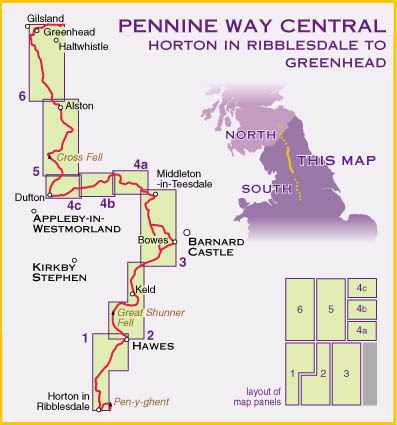
Mooie, duidelijke kaart van het middelste gedeelte van de Pennine Way (Horton in Ribblesdale to Greenhead).
De complete wandeling beslaat 431 kilometer en bestaat uit 3 kaarten. Deze 3 kaarten zijn ook als set verkrijgbaar.
The Pennine Way is a National Trail. It follows the backbone of England from the Peak District to the Scottish borders. It is one of the toughest UK long distance footpaths, and forms part of the European Footpath Network.
The Pennine Way was Britain's first National Trail, opened in 1965.
Just 3 HARVEY maps cover the whole 268-mile route. Each covers a section of the Way suitable for a comfortable week of walking. Each starts and finishes near public transport, so no hassle with getting lifts.
Each also contains lots of information and useful telephone numbers to assist the walker with planning.
Pennine Way Central covers the route from Horton-in-Ribblesdale to Greenhead.
This map is bio-degradable
Information on finding accommodation, camping, food. Directions to the start. Also Ranger Service contact numbers and enlargements of towns/villages showing facilities available and tips on weather and clothing
Detailed mapping, full legend. National Grid - can be used with GPS. 1:40,000 scale. Waterproof. Supplied in clear plastic pocket
Reviews
Geen reviews gevonden voor dit product.
Schrijf een review
Graag horen wij wat u van dit artikel vindt. Vindt u het goed, leuk, mooi, slecht, lelijk, onbruikbaar of erg handig: schrijf gerust alles op! Het is niet alleen leuk om te doen maar u informeert andere klanten er ook nog mee!
Ook interessant voor europa/engeland/overig-noord-2

