Winkelwagen
Geen items in winkelwagen
Ga naar winkelwagen
Topografische kaarten - Europa
 Wandelkaart - Topografische kaart 1730 SB - Serie Bleue Ruffec - Villefagnan | IGN - Institut Géographique National
 Wandelkaart - Topografische kaart 1731 SB - Serie Bleue Mansle | IGN - Institut Géographique National
 Wandelkaart - Topografische kaart 1732 SB - Serie Bleue Angoulême, Ruelle-sur-Touvre | IGN - Institut Géographique National
 Wandelkaart - Topografische kaart 1733 SB - Serie Bleue Montmoreau-Saint-Cybard | IGN - Institut Géographique National
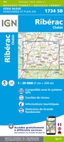 Wandelkaart - Topografische kaart 1734 SB - Serie Bleue Ribérac - Chalais | IGN - Institut Géographique National
 Wandelkaart - Topografische kaart 1735 SB - Serie Bleue Montpon-Ménestérol ,Saint-Médard-de-Mussidan | IGN - Institut Géographique National
 Wandelkaart - Topografische kaart 1736 SB - Serie Bleue Ste-Foy-la-Grande, Vélines | IGN - Institut Géographique National
 Wandelkaart - Topografische kaart 1737 SB - Serie Bleue Monségur | IGN - Institut Géographique National★★★★★
 Wandelkaart - Topografische kaart 1738 SB - Serie Bleue Marmande - Seyches | IGN - Institut Géographique National
 Topografische kaart - Wandelkaart 1739 SB - Serie Bleue Tonneins - Casteljaloux | IGN - Institut Géographique National
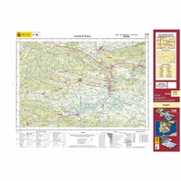 Topografische kaart 174 MT50 Sangüesa | CNIG - Instituto Geográfico Nacional1
 Wandelkaart - Topografische kaart 174 Landranger Newbury & Wantage, Hungerford & Didcot | Ordnance Survey
 Wandelkaart - Topografische kaart 174 OS Explorer Map Epping Forest, Lee Valley | Ordnance Survey
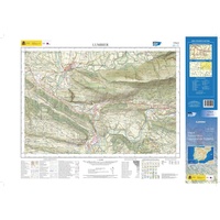 Topografische kaart 174-II Lumbier | CNIG - Instituto Geográfico Nacional1
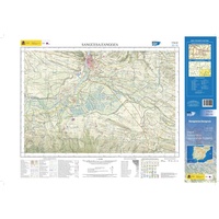 Topografische kaart 174-IV Sangüesa / Zangoza | CNIG - Instituto Geográfico Nacional1
 Wandelkaart - Topografische kaart 1740 SB - Serie Bleue Nérac | IGN - Institut Géographique National
 Wandelkaart - Topografische kaart 1741 SB - Serie Bleue Mézin | IGN - Institut Géographique National
 Topografische kaart - Wandelkaart 1742 SB - Serie Bleue Eauze | IGN - Institut Géographique National★★★★★
 Wandelkaart - Topografische kaart 1743 SB - Serie Bleue Plaisance - Montesquiou | IGN - Institut Géographique National
 Wandelkaart - Topografische kaart 1744 SB - Serie Bleue Miélan - Vic en Bigorre | IGN - Institut Géographique National
Laatste reviews

Goede, overzichtelijke kaart van Apeldoorn en directe omgeving..
Snelle levering van deze gedetaileerde kaart van Apeldoorn.
★★★★★ door Frans Alderse Baas 22 april 2026 | Heeft dit artikel gekocht
Precies het juiste gebied
Kaart gekocht voor de wandeling die ik in de zomer ga maken. Kon niet helemaal zien of de kaart dekkend was. Maar dat is 't …
★★★★★ door Harry 22 april 2026 | Heeft dit artikel gekocht
Prima
Wanneer je in de logistiek zit is zo'n bureaulegger erg handig.
★★★★★ door Frank Rosier 22 april 2026 | Heeft dit artikel gekocht
Stevige kaart, maar voldoet niet wat mij betreft
De kaart maakt geen onderscheid tussen hoofd- en andere wegen. Ook de wegen nummers en afslag nummers ontbreken. Over het algemeen in het Grieks beschreven. …
★★★★★ door sjaak den dubbelden 22 april 2026 | Heeft dit artikel gekocht