National Geographic
Dit bekende tv-kanaal heeft naast prachtige natuurdocumontaires en magazines ook zijn eigen reisgidsen en wegenkaarten uitgegeven. De landkaarten zijn gedrukt op scheurvast en waterbestendig papier wat een vergrootte levensduur betekent. De kaarten zijn helder en bevatten een schat aan informatie voor zowel de 'gewone' toerist als de avonturier. De hoofdwegen zijn duidelijk aangegeven, maar ook de secundaire wegen en tracks staan er op. Met de nationale parken duidelijk en mooie zwemplekken of attracties aangegeven onderscheidt deze kaartenserie zich van de andere wegenkaarten. De kaarten heten dan ook niet voor niets Adventure Maps! Het avontuur wacht!
 Wandkaart Korean Peninsula Noord- en Zuid Korea, 59 x 91 cm | National Geographic
Amid increasingly combative rhetoric from Pyongyang, North Korea, do you know where its underground nuclear test site or missile launch centers are located? Are you aware that the South Korean …
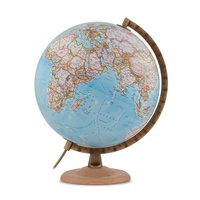 Wereldbol - Globe Gold Classic Blauw ø 30 cm | Engelstalig | Met Verlichting | National Geographic
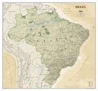 Wandkaart Brazil - Brazillië Antiek, 104 x 97 cm | National Geographic
Presented in National Geographic’s classic wall map style, our large, earth-tone Brazil wall map is ideal for home or office. Inherent to all National Geographic reference cartography, this map contains …
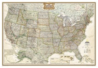 Wandkaart USA - Verenigde Staten Antiek, 111 x 77 cm | National Geographic
Wandkaart van de USA waarbij de kleuren in 'antieke' look zijn weergegeven, de staatgrenzen zeer duidelijk zijn en er veel plaatsen op staan. This Antique-style USA Wall Map by …
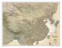 Wandkaart China, antiek, 76 x 59 cm | National Geographic
This detailed political map of China accurately shows locations of provincial boundaries, cities and towns, major highways and roads, rivers and waterways, and other geographic features.
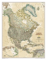 Wandkaart Noord Amerika, politiek & antiek, 60 x 78 cm | National Geographic
This richly colored map of North America - featuring country boundaries, place names, major highways and roads, and bodies of water - is excellent for reference in your home or …
 Wandkaart Scotland – Schotland, 76 x 91 cm | National Geographic
This new map of Scotland, features our rich, antique-inspired Executive style. This beautiful map includes thousands of place names, accurate political boundaries, national parks, archeological sites, and major infrastructure networks …
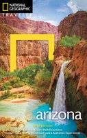 Reisgids Arizona | National Geographic
The American southwest, from the Grand Canyon to the desert landscapes, has always held allure for visitors from around the world. Acclaimed travel author Bill Weir, author of more than …
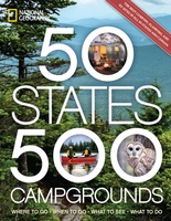 Campinggids - Campergids 50 States - 500 Campgrounds USA en Canada | National Geographic
Plan your next getaway to the great outdoors with this one-of-a-kind resource for campgrounds across North America. In this comprehensive sequel to the best-selling 50 States, 5,000 Ideas, you'll discover …
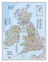 Magneetbord - Wandkaart British Isles - Groot Brittannië en Ierland, 61 x 76 cm | National Geographic
Magneetbord van een wandkaart van Groot Brittannië en Ierland: prachtig kaartbeeld met heel veel details, gemaakt door de gerenommeerde makers van National Geographic. British Isles at 1:1,687,000 on a small …
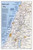 Wandkaart Holy Land – Israël, 53 x 80 cm | National Geographic
National Geographic Wall Maps offer a special glimpse into current and historical events, and they inform about the world and environment. Offered in a variety of styles and formats, these …
 Wereldbol - Globe Cross Classic | ø 50 cm | Engelstalig | National Geographic
 Reisgids Zonnestelsel | National Geographic
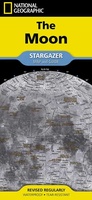 Reisgids Maan | National Geographic
 Wereldkaart Politiek, 186 x 122 cm | National Geographic
This map has spectacular color and detail to bring the world alive! Enjoy the accuracy and beauty of this world map, which features the Winkel Tripel projection to reduce distortion …
 Reisgids Night Sky | Sterrenhemel - Zuidelijk halfrond | National Geographic
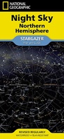 Sterrenkaart - Planisfeer Sterrenhemel - noordelijk halfrond | National Geographic
 Klassieke wereldbol Gold Executive ø 30 cm | Engelstalig | Met verlichting | National Geographic
Deze mooie wereldbol toont een heldere cartografie met duidelijke landsgrenzen en gearceerde reliëfkaarten. De wereldbol heeft een diameter van 30 cm, is 40 cm hoog en heeft een gegoten metalen …
 Wandkaart The Balkans - Balkan landen, 77 x 60 cm | National Geographic
Study the countries of the Balkans with our new map featuring the classic National Geographic reference styling. Features thousands of place names, accurate political boundaries, national parks, and major infrastructure …
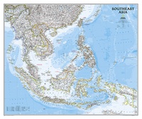 Wandkaart Zuidoost Azië, politiek, 96 x 81 cm | National Geographic
The Southeast Asia Political Map is a detailed reference map containing National Geographic’s clear visual presentation in a bright and appealing color palette. The map contains thousand of place names, …
Laatste reviews

Prachtige wandelgids voorzien van alle voor de wandelaars benodigde informatie (accommodaties, restaurants en cafés, vervoersmogelijkheden enz.). Ook is de gids beschreven in twee richtingen en …
★★★★★ door Mathie Hoenjet 27 juni 2026 | Heeft dit artikel gekocht
Zoals altijd duidelijke en overzichtelijke kaart van Michelin
★★★★★ door Charles Trippelvitz 26 juni 2026 | Heeft dit artikel gekocht
Door deze gids konden we ons heel goed voorbereiden op onze fietstocht. En het gebruik onderweg was ook prima. Jammer dat de campings onderweg wat …
★★★★★ door Helma Feenstra 26 juni 2026 | Heeft dit artikel gekocht
Kort voor vakantie naar de Galapagos eilanden toch nog behoefte aan extra reisgids. Simpel kunnen bestellen en snelle levering. Zou niet weten wat er beter …
★★★★★ door Piet Grootenboer 25 juni 2026 | Heeft dit artikel gekocht