National Geographic
Dit bekende tv-kanaal heeft naast prachtige natuurdocumontaires en magazines ook zijn eigen reisgidsen en wegenkaarten uitgegeven. De landkaarten zijn gedrukt op scheurvast en waterbestendig papier wat een vergrootte levensduur betekent. De kaarten zijn helder en bevatten een schat aan informatie voor zowel de 'gewone' toerist als de avonturier. De hoofdwegen zijn duidelijk aangegeven, maar ook de secundaire wegen en tracks staan er op. Met de nationale parken duidelijk en mooie zwemplekken of attracties aangegeven onderscheidt deze kaartenserie zich van de andere wegenkaarten. De kaarten heten dan ook niet voor niets Adventure Maps! Het avontuur wacht!
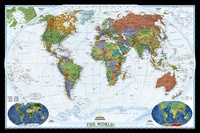 Wereldkaart World Decorator, 108 x 75 cm | National Geographic
This map has spectacular color and detail to bring the world alive! Enjoy the accuracy and beauty of this world map, which features the Winkel Tripel projection to reduce distortion …
 Stadsplattegrond Londen | National Geographic
 Klassieke wereldbol Cross Executive | ø 50cm | Engelstalig | National Geographic
 Wegenkaart - landkaart Africa - Afrika | National Geographic
• Waterproof • Tear-Resistant • Reference Map Expertly researched and designed, National Geographic's Africa Flags & Facts Map is the authoritative map of Africa by which other reference …
 Wegenkaart - landkaart Sierra Nevada | National Geographic
&; Waterproof &; Tear-Resistant &; Travel Map National Geographic's Sierra Nevada Destination Map strikes the perfect balance between map and guidebook and is an ideal resource for touring the …
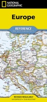 Wegenkaart - landkaart Europe - Europa | National Geographic
• Waterproof • Tear-Resistant • Reference Map Expertly researched and designed, National Geographic's Europe Flags & Facts Map is the authoritative map of Europe by which other reference maps …
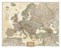 Wandkaart Europa, politiek & antiek, 77 x 60 cm | National Geographic
National Geographic is a renowned authority in cartography. For 120 years the Society's maps have helped spread geographic knowledge around the globe. A vast database allows National Geographic to combine …
 Wegenkaart - landkaart United States Map (folded with flags and facts) - Verenigde Staten + vlaggen + info | National Geographic
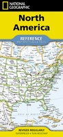 Wegenkaart - landkaart North America - Noord Amerika | National Geographic
• Waterproof • Tear-Resistant • Reference Map Expertly researched and designed, National Geographic's North America Flags & Facts Map is the authoritative map of North America by which other …
 Wegenkaart - landkaart South America and Antarctica | National Geographic
• Waterproof • Tear-Resistant • Reference Map Expertly researched and designed, National Geographic's South America and Antarctica Flags & Facts Map is the authoritative map of South America by …
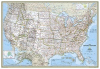 Wandkaart USA - Verenigde Staten Political, 178 x 124 cm | National Geographic
Het klassieke kaartbeeld van National Geographic, de grenzen van de staten van Amerika zijn apart gekleurd. De wandkaart is heel gedetailleerd met veel plaatsen, wegen, rivieren en nationale parken, het …
 Fotoboek Yellowstone | National Geographic
Best-selling author David Quammen takes readers on a breathtaking journey through America's most inspiring and imperiled ecosystem--Yellowstone National Park--in this monumental book on America's first national park. Yellowstone's storied past, …
 Wandkaart Afrika, politiek, 91 x 118 cm | National Geographic
Mooie wandkaart van Afrika, staatkundig, met rustig kleurgebruik en helder kaartbeeld, Ondanks het wat kleiner formaat staan er toch heel wat topografische details op vermeld. The map presents Africa …
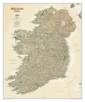 Wandkaart Ierland, antiek, 76 x 92 cm | National Geographic
National Geographic Maps' new Ireland wall map is one of the most authoritative maps yet published of the Emerald Isle. Of the nearly 1,000 place-names shown on this map, all …
 Wereldkaart Dynamic earth plate tectonics, 92 x 61 cm | National Geographic
The new Dynamic Earth wall map illustrates plate tectonics and features new bathymetry and naturally colored relief, as well as current volcano and earthquake data. Notable earthquakes and eruptions lists …
 Wandkaart Duitsland, antiek, 60 x 77 cm | National Geographic
Complete political actual detail of Germany - country boundaries, roads and cities, airports, bodies of water, and other geographic details in antique style.
 Fotoboek Wild, Beautiful Places | National Geographic
National Geographic photography captures the world's most remote, exotic places in this visually stunning travel book full of scenic wonders to experience. Highlighting 50 of Earth's most pristine, scenic locales, …
 Wereldkaart Politiek & antiek, 82 x 51 cm | National Geographic
The World Explorer Executive uses the Winkel-Tripel Map Projection, which strikes the best balance of accuracy, aesthetics, and proportion, eliminating the issue found in many other maps where Greenland appears …
 Wandkaart Azië, politiek & antiek, 84 x 96 cm | National Geographic
Mooie wandkaart van Azië, staatkundig, met rustig kleurgebruik en helder kaartbeeld; deze kaart heeft een antieke uitstraling door gebruik van aarde-kleuren. Ondanks het wat kleine formaat staan er toch heel …
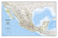 Wandkaart Mexico, 88 x 57 cm | National Geographic
Decoratieve wandkaart van Mexico. Naast de mooie kleuren staan er bijzonder veel plaatsen op vermeld. This finely detailed National Geographic political map of Mexico shows country boundaries, cities and towns, …
★★★★★
Laatste reviews

Prachtige wandelgids voorzien van alle voor de wandelaars benodigde informatie (accommodaties, restaurants en cafés, vervoersmogelijkheden enz.). Ook is de gids beschreven in twee richtingen en …
★★★★★ door Mathie Hoenjet 27 juni 2026 | Heeft dit artikel gekocht
Zoals altijd duidelijke en overzichtelijke kaart van Michelin
★★★★★ door Charles Trippelvitz 26 juni 2026 | Heeft dit artikel gekocht
Door deze gids konden we ons heel goed voorbereiden op onze fietstocht. En het gebruik onderweg was ook prima. Jammer dat de campings onderweg wat …
★★★★★ door Helma Feenstra 26 juni 2026 | Heeft dit artikel gekocht
Kort voor vakantie naar de Galapagos eilanden toch nog behoefte aan extra reisgids. Simpel kunnen bestellen en snelle levering. Zou niet weten wat er beter …
★★★★★ door Piet Grootenboer 25 juni 2026 | Heeft dit artikel gekocht