Winkelwagen
Geen items in winkelwagen
Ga naar winkelwagen
IGN - Institut Géographique National
IGN is de officiële instantie voor geografische informatie in Frankrijk ofwel Institut Géographique National. Ze staan bekend om de zeer goede wandelkaarten op schaal 1:25.000 (Serie Bleue en Top 25) van Frankrijk. De wandelkaarten zijn dan ook zeer uitgebreid. De wandelaar vindt hier alle wandelpaden, campings en langeafstandswandelpaden, ook wel GR-paden (Grande Randonnée) genoemd. Kleine weggetjes en paden, maar ook de verschillende types landschappen en bebouwingen, populaire gebieden en onontdekte parels: de wandelaar in Frankrijk vindt alles terug op deze betrouwbare kaarten van IGN.
Naast wandelkaarten geeft het IGN ook goede fiets- c.q. wegenkaarten op schaal 1:100.000 (serie Top 100) en fietskaarten op schaal 1:75.000 (serie Top 75) uit.
 Reliëfkaart 60180 Pays-Basque met voelbaar 3D reliëf | 113 x 80 cm | IGN - Institut Géographique National★★★★★
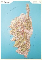 Reliëfkaart 60201 Corsica met voelbaar 3D reliëf | 113 x 80 cm | IGN - Institut Géographique National
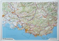 Reliëfkaart 60202 Provence met voelbaar 3D reliëf | 113 x 80 cm | IGN - Institut Géographique National
 Reliëfkaart 60203 Pyrénées Ariègeoises & Catalanes met voelbaar 3D | 113 x 80 cm reliëf | IGN - Institut Géographique National
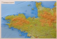 Reliëfkaart 60303 Bretagne-Cotentin met voelbaar 3D reliëf | 113 x 80 cm | IGN - Institut Géographique National
 Wandelkaart - Topografische kaart 618 SB - Serie Bleue Sillé-le-Guillaum, Conlie Ste-Suzanne | IGN - Institut Géographique National
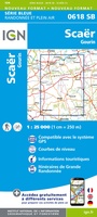 Wandelkaart - Topografische kaart 618 SB - Serie Bleue Scaër | IGN - Institut Géographique National
 Fietskaart 7 Velo Finistere a Velo - Finistere by Bike - Bretagne | IGN - Institut Géographique National
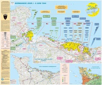 Wandkaart 70044 Normandie Jour J | D-Day | 132 x 100 cm | IGN - Institut Géographique National
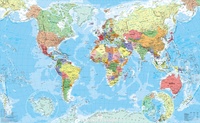 Wereldkaart 70046 Monde Politique Poster | 100 x 62 cm | IGN - Institut Géographique National
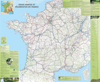 Wandkaart 70055 Poster Voies vertes & véloroutes - Groene Fietspaden - Groene fietsroutes Frankrijk | 98 x 119 cm | IGN - Institut Géographique National
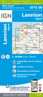 Wandelkaart - Topografische kaart 715 SB - Serie Bleue Bégard - Lannion | IGN - Institut Géographique National
 Wandelkaart - Topografische kaart 716 SB - Serie Bleue Belle-Isle-en-Terre, Guerlesquin | IGN - Institut Géographique National
 Wandelkaart - Topografische kaart 717 SB - Serie Bleue Carhaix-Plouguer, Maël-Carhaix | IGN - Institut Géographique National
 Wandelkaart - Topografische kaart 718 SB - Serie Bleue Rostrenen | IGN - Institut Géographique National
 Wandelkaart 719 SB - Serie Bleue Plouay / Le Faouët | IGN - Institut Géographique National
 Wegenkaart - landkaart 721300 Ain - Rhône | IGN - Institut Géographique National
 Wegenkaart - landkaart 721307 Aube - Haute-Marne | IGN - Institut Géographique National
 Wegenkaart - landkaart 721321 D28 Eure-et-Loir | IGN - Institut Géographique National
 Wegenkaart - landkaart 721326 Gironde | IGN - Institut Géographique National
Laatste reviews

Super
Rother wandelgidsen stellen nooit teleur. Mooie routes, goede opgave kilometers, hoogtemeters en horeca. Een aanrader!
★★★★★ door Anita Geel 13 januari 2026 | Heeft dit artikel gekocht
Prachtig boek!
Mooi boek met prachtige foto’s! Voldoet helemaal aan mijn verwachtingen.
★★★★★ door Hans Eldering 13 januari 2026 | Heeft dit artikel gekocht
zeer vlotte levering
het product voldeed aan mijn verwachtingen en was geplastificeerd wat natuurlijk perfect is voor kaart die veel wordt geraadpleegd!
★★★★★ door Peter Lantinga 13 januari 2026 | Heeft dit artikel gekocht
Gedetailleerde wegenkaart
Ik heb de wegenkaart Maleisië aangeschaft om zelf een rondreis per huurauto te kunnen plannen. Deze kaart heeft daar heel goed bij geholpen doordat er …
★★★★★ door M. Rizvi 13 januari 2026 | Heeft dit artikel gekocht