Winkelwagen
Geen items in winkelwagen
Ga naar winkelwagen
IGN - Institut Géographique National
IGN is de officiële instantie voor geografische informatie in Frankrijk ofwel Institut Géographique National. Ze staan bekend om de zeer goede wandelkaarten op schaal 1:25.000 (Serie Bleue en Top 25) van Frankrijk. De wandelkaarten zijn dan ook zeer uitgebreid. De wandelaar vindt hier alle wandelpaden, campings en langeafstandswandelpaden, ook wel GR-paden (Grande Randonnée) genoemd. Kleine weggetjes en paden, maar ook de verschillende types landschappen en bebouwingen, populaire gebieden en onontdekte parels: de wandelaar in Frankrijk vindt alles terug op deze betrouwbare kaarten van IGN.
Naast wandelkaarten geeft het IGN ook goede fiets- c.q. wegenkaarten op schaal 1:100.000 (serie Top 100) en fietskaarten op schaal 1:75.000 (serie Top 75) uit.
 Wandelkaart - Topografische kaart 1828 SB - Serie Bleue Gençay - Persac | IGN - Institut Géographique National
 Wandelkaart - Topografische kaart 1829 SB - Serie Bleue L'Isle-Jourdain - Charroux | IGN - Institut Géographique National
 Wandelkaart - Topografische kaart 1830 SB - Serie Bleue Confolens | IGN - Institut Géographique National
 Wandelkaart - Topografische kaart 1831 SB - Serie Bleue Rochefoucauld - Exideuil | IGN - Institut Géographique National
 Wandelkaart - Topografische kaart 1832 SB - Serie Bleue Montbron, Piégut-Pluviers | IGN - Institut Géographique National★★★★★
 Wandelkaart - Topografische kaart 1833 SB - Serie Bleue Nontron, Brantôme, Mareuil | IGN - Institut Géographique National
 Wandelkaart - Topografische kaart 1834 SB - Serie Bleue Périgueux , Tocane-Saint-Apre | IGN - Institut Géographique National
 Wandelkaart - Topografische kaart 1835 SB - Serie Bleue Villamblard, Saint-Astier, Mussidan | IGN - Institut Géographique National
 Wandelkaart - Topografische kaart 1836 SB - Serie Bleue Creysse - Bergerac | IGN - Institut Géographique National
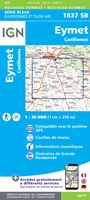 Wandelkaart - Topografische kaart 1837 SB - Serie Bleue Eymet - Castillonnès | IGN - Institut Géographique National
 Wandelkaart 1838 SB - Serie Bleue Cancon - Miramont-de-Guyenne | IGN - Institut Géographique National
 Wandelkaart - Topografische kaart 1839 SB - Serie Bleue Villeneuve sur Lot - Castelmoron sur Lot | IGN - Institut Géographique National
 Topografische kaart - Wandelkaart 1841 SB - Serie Bleue Condom | IGN - Institut Géographique National
 Topografische kaart - Wandelkaart 1843 SB - Serie Bleue Auch | IGN - Institut Géographique National
 Wandelkaart - Topografische kaart 1844 SB - Serie Bleue Mirande - Masseube | IGN - Institut Géographique National
 Wandelkaart - Topografische kaart 1845 SB - Serie Bleue Boulogne-sur-Gesse | IGN - Institut Géographique National
 Wandelkaart - Topografische kaart 1846 SB - Serie Bleue Lannemezan | IGN - Institut Géographique National
 Wandelkaart - Topografische kaart 1847OT Saint Bertrand de Comminges, Arreau | IGN - Institut Géographique National
 Wandelkaart - Topografische kaart 1848OT Bagnères de Luchon, | IGN - Institut Géographique National★★★★★
 Wandelkaart - Topografische kaart 1848OTR Bagnères-de-Luchon | IGN - Institut Géographique National
Laatste reviews

Verassend goede en rijke wandelgids
Deze gids bevat een schat an informatie over talloze rondwandelingen langs de Jurassic Coast, met veel aandacht voor de geologische aspecten van deze kust. De …
★★★★★ door Raymond Franssen 13 juni 2026 | Heeft dit artikel gekocht
Informatief boekje
In deze nieuwe uitgave ontbreekt de routebeschrijving. Het bevat daar ipv veel info over de omgeving. Dat is leuk. De route is goed te wandelen …
★★★★★ door Irma Smit 13 juni 2026 | Heeft dit artikel gekocht
Goede kaart
Duidelijke kaart voor gebied te verkennen met Moto
★★★★★ door Van Puymbroeck René 12 juni 2026 | Heeft dit artikel gekocht
Fijne kaart
Goede leesbare kaart inclusief route suggesties. Heb alleen op de kaart gelopen, zonder mobiele apparatuur. Heel goed te doen.
★★★★★ door Nick 10 juni 2026 | Heeft dit artikel gekocht