Winkelwagen
Geen items in winkelwagen
Ga naar winkelwagen
Kaarten
De beste wegenkaarten, routekaarten, fiets- of wandelkaarten en topografische kaarten vindt u hier!
Gaat u wandelen, met de auto toeren of op andere manier de omgeving op uw vakantiebestemming verkennen? Onze tip: neem een goede kaart mee! Er zijn speciale kaarten beschikbaar voor campervakanties, fietsroutes, pelgrimsroutes, wandeltochten en veel meer. Ook wegenatlassen en wegenkaarten kunnen handig zijn onderweg.
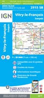 Wandelkaart - Topografische kaart 2915 SB - Serie Bleue Vitry-le-François, Sompuis | IGN - Institut Géographique National
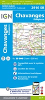 Wandelkaart - Topografische kaart 2916 SB - Serie Bleue Chavanges, Dampierre | IGN - Institut Géographique National
 Wandelkaart - Topografische kaart 2917 SB - Serie Bleue Brienne-le-Chateau, Piney, Lacs de la Foret d'Orient | IGN - Institut Géographique National
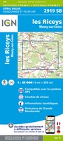 Topografische kaart - Wandelkaart 2919 SB - Serie Bleue les Riceys | IGN - Institut Géographique National
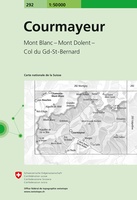 Wandelkaart - Topografische kaart 292 Courmayeur | Swisstopo
 Wandelkaart - Topografische kaart 292 OS Explorer Map Withernsea & Spurn Head | Ordnance Survey
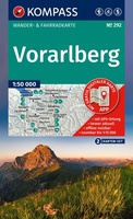 Wandelkaart 292 Vorarlberg | Kompass★★★★★
 Topografische kaart 292 MT50 Sant Llorenç de Morunys | CNIG - Instituto Geográfico Nacional1
 Topografische kaart - Wandelkaart 2920 SB - Serie Bleue Châtillon-sur-Seine | IGN - Institut Géographique National
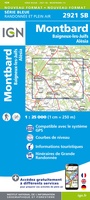 Topografische kaart - Wandelkaart 2921 Baigneux-les-Juifs, Alésia, Montbard | IGN - Institut Géographique National
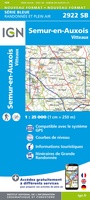 Wandelkaart - Topografische kaart 2922 SB - Serie Bleue Semur-en-Auxois – Vitteaux | IGN - Institut Géographique National★★★★★
 Wandelkaart - Topografische kaart 2923 SB - Serie Bleue Pouilly-en-Auxois – Thoisy-la-Berchère | IGN - Institut Géographique National
 Wandelkaart - Topografische kaart 2924 SB - Serie Bleue Arnay-le-Duc – Epignac | IGN - Institut Géographique National★★★★★
 Wandelkaart - Topografische kaart 2925 SB - Serie Bleue Autun - Le Creusot | IGN - Institut Géographique National
 Wandelkaart - Topografische kaart 2926 SB - Serie Bleue Montceau-les-Mines, Ecuisses | IGN - Institut Géographique National
 Wandelkaart - Topografische kaart 2927 SB - Serie Bleue St-Bonnet-de-Joux – Saint-Gengoux-le-National | IGN - Institut Géographique National
 Wandelkaart - Topografische kaart 2928 SB - Serie Bleue Cluny Matour | IGN - Institut Géographique National
 Wandelkaart - Topografische kaart 2929ET Beaujeu - Belleville - Haut Beaujolais – Rhônevallei – Bourgondië | IGN - Institut Géographique National
 Toerskikaart 292S Ski kaart Mont Blanc / Chamonix / Courmayeur / Gd-St-Bernard | Swisstopo
 Topografische kaart 293 MT50 Berga | CNIG - Instituto Geográfico Nacional1
Laatste reviews

Duidelijke wandelkaart
De website is zeer overzichtelijk waar de wandelkaarten zeer snel en makkelijk te vinden zijn.
★★★★★ door Peter Badoux 04 februari 2026 | Heeft dit artikel gekocht
Handige en overzichtelijke kaart
Blij met deze aankoop. De kaart is niet te groot en heel overzichtelijk. De kwaliteit van het papier is wat dun en daarom hebben wij …
★★★★★ door Loes van de Waerdt 04 februari 2026 | Heeft dit artikel gekocht
Keurig nette snelle service v mooi product
Goed verpakte prachtige kaarten en ook nog snel in de bus.
★★★★★ door Ruth 03 februari 2026 | Heeft dit artikel gekocht
Top boeken en kaart
Goede en duidelijke beschrijving van de wandelgids. Ook kaart goed en duidelijk
★★★★★ door N. Barink 02 februari 2026 | Heeft dit artikel gekocht