Superwalker XT25 maps
De ultieme kaarten voor wandelaars: ontdek de Super Walker XT25 Maps van Harvey Maps
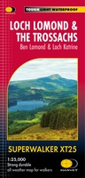 Wandelkaart Loch Lomond & The Trossachs | Harvey Maps
Detailed Superwalker map for walkers of Loch Lomond & the Trossachs National Park at 1:25,000 scale. Includes Scotland?s most southerly Munro, Ben Lomond and an inset map for access to …
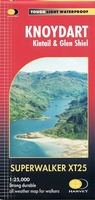 Wandelkaart Knoydart / Kintail / Glen Shiel harvey | Harvey Maps
This remote and beautiful area is often known as 'Scotland's last wilderness'. Detailed map for hillwalkers of Knoydart and Glen Shiel at the popular scale of 1:25,000. Includes …
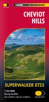 Wandelkaart Cheviot Hills | Harvey Maps
Includes the Cheviot, Newton Tors and Kirknewton. Detailed map for hillwalkers and cyclists of the Cheviot Hills at 1:25,000 scale. Includes the northern section of the Pennine Way from Brownhart …
 Wandelkaart Lake District East | Harvey Maps
 Wandelkaart Lake District Noord | Harvey Maps
New Superwalker XT25 of the Lake District. Revised and re-designed It's got everything! Genuine original HARVEY mapping at 1:25,000. Clear, easy to read. Easy to re-fold. Opens directly to either …
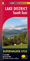 Wandelkaart Lake District Zuid Oost | Harvey Maps
Superwalker XT25 of the Lake District. Revised and re-designed. It's got everything! Genuine original HARVEY mapping at 1:25,000. Clear, easy to read. Easy to re-fold. Opens directly to either side …
 Wandelkaart Exmoor | Harvey Maps
 Wandelkaart Ben Lawers & Schiehallion | Harvey Maps
Harvey Maps for hillwalkers showing the hills from Loch Tay to Glen Lyon. This detailed walking map includes Ben Lawers and the Tarmachan Ridge. The Superwalker XT25 is based on …
 Wandelkaart Arran including Arran Coastal Way | Harvey Maps
Een bijzonder handige kaart van dit gebied. Op waterafstotend papier met veel details. Features the renowned Goat Fell, A'Chir ridge, Beinn Bharrain, Glen Sannox & Glen Rosa. Detailed map …
★★★★★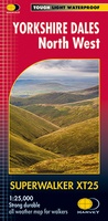 Wandelkaart Yorkshire Dales Noord-West | Harvey Maps
The Yorkshire Dales National Park on just 4 sheets. Yorkshire Dales North West: The coverage of this map includes The Howgill Fells, upper Wensleydale and upper Swaledale. Genuine original HARVEY …
 Wandelkaart Yorkshire Dales Zuid-West | Harvey Maps
The Yorkshire Dales National Park on just 4 sheets. Yorkshire Dales South West: The coverage of this map includes Yorkshire Three Peaks, Whernside, Ingleborough and Pen-y-Ghent. Genuine original HARVEY mapping …
 Wandelkaart Brecon Beacons Oost | Harvey Maps
Includes Pen y Fan and the Black Mountains. Detailed map for hillwalkers of the western part of the Brecon Beacons National Park at the popular scale of 1:25,000. …
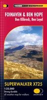 Wandelkaart Foinaven & Ben Hope | Harvey Maps
 Wandelkaart Snowdonia Central | Harvey Maps
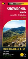 Wandelkaart Snowdonia South | Harvey Maps
Laatste reviews

Op zich een goede kaart, maar het is eigenlijk gewoon een uitvergroting van de bekende 1:200.000-kaarten, dus weinig tot geen extra informatie. Wel wat duidelijker …
★★★★★ door FGM Ballhaus 13 mei 2026 | Heeft dit artikel gekocht
Duidelijke kaart, goed voor fietsen, iets minder voor wandelen door de schaal, maar er is heel weinig kaartmateriaal voor dit gebied dus daarom toch dik …
★★★★★ door FGM Ballhaus 13 mei 2026 | Heeft dit artikel gekocht
Fietskaart is een goede aanvulling op de Nederlandse fietskaarten, laat de Achterhoek zien maar ook een heel stuk Duitsland in (naar het oosten). Kwalitatief ook …
★★★★★ door FGM Ballhaus 13 mei 2026 | Heeft dit artikel gekocht
Keurig verpakt, snel verzonden. Boek voldoet aan mijn verwachtingen!
★★★★★ door Beatrice 12 mei 2026 | Heeft dit artikel gekocht