Wegenkaart - landkaart Manitoba | ITMB (9781553418207)
- ISBN / CODE: 9781553418207
- Editie: 22-07-2009
- Druk: 1
- Aantal blz.: 1
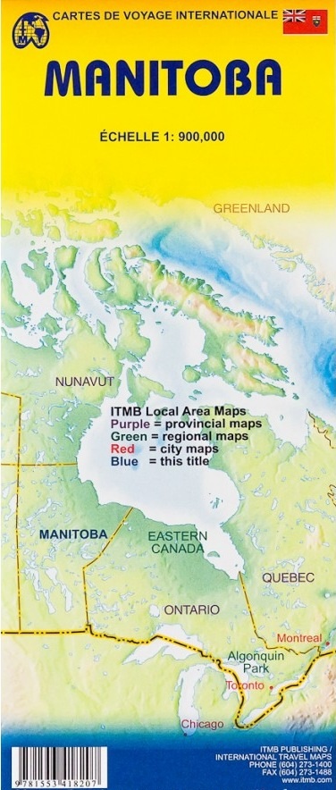
- Schaal: 1:900000
- Uitgever: ITMB
- Soort: Wegenkaart
- Taal: Engels
- Hoogte: 25.0 cm
- Breedte: 10.0 cm
- Gewicht: 52.0 g
- Bindwijze: -
- Uitvoering: Papier
- Beoordeling: 5,0 ★★★★★ (1 review) Schrijf een review
-
€ 13,95
Uitverkocht, nooit meer leverbaar
Beschrijving
TMB is steadily mapping Canada one little bit at a time. Being Canada, those ‘bits’ tend to be rather large. Manitoba is the huge province west of Ontario and east of Saskatchewan. It stretches from the American border to the Arctic, and is the only ‘maritime’ part of Canada that is also in the middle of the country (the port of Churchill, on Hudson Bay, is a seaport). Settled initially by nomadic people decended from the migration across the Bering Straits in pre-historic times, the fur trade opened the region to exploration in the 1700s and to small-scale settlement in the vicinity of modern-day Winnipeg. Manitoba’s tourism potential is based on wilderness outdoor activity, as is the case with most of Canada. The map certainly shows the developed southern portion of the province to good advantage, showing parks, secondary roads, and farming communities in excellent detail, as well as lakes and physical features. The second side of the map shows the larger northern half of the province at the same scale. This is polar bear country, muskeg, and fly-in fishing country – true wilderness. The map also includes an inset of central Winnipeg; printed on paper;
Reviews
Zeer complete kaart, inclusief bezienswaardigheden langs de weg. Mooie vakantie naar de ijsberenstad Churchill mee gemaakt
★★★★★ door Jan 16 oktober 2014Vond u dit een nuttige review? (login om te beoordelen)
Schrijf een review
Graag horen wij wat u van dit artikel vindt. Vindt u het goed, leuk, mooi, slecht, lelijk, onbruikbaar of erg handig: schrijf gerust alles op! Het is niet alleen leuk om te doen maar u informeert andere klanten er ook nog mee!
Ook interessant voor noord-amerika/canada/overig-oost
-

Wegenkaart - landkaart Kanada - Cana
€ 14,95Wegenkaarten Canada -

Wegenatlas Road Atlas USA Canada Mex
€ 21,95Wegenatlassen Mexico -

Stadsplattegrond Montréal | Borch
€ 9,95Stadsplattegronden Montreal -

Wandkaart Noord Amerika, politiek, 1
€ 38,95Wandkaarten van landen Canada -

Reisgids Newfoundland & Labrador | M
€ 18,50Reisgidsen Atlantisch Canada