Winkelwagen
Geen items in winkelwagen
Ga naar winkelwagen
Wegenkaart - landkaart Virgin Islands - Maagden eilanden | Borch (9783866095175)

- ISBN / CODE: 9783866095175
- Editie: 22-08-2014
- Druk: 5
- Aantal blz.: 1
- Schaal: 1:80000
- Uitgever: Borch
- Soort: Wegenkaart
- Taal: Engels
- Hoogte: 25.0 cm
- Breedte: 11.0 cm
- Gewicht: 72.0 g
- Uitvoering: Scheur- en watervast
- Bindwijze: -
- Schrijf als eerste een review
-
€ 11,95
Dit artikel is (tijdelijk) niet leverbaar


Beschrijving
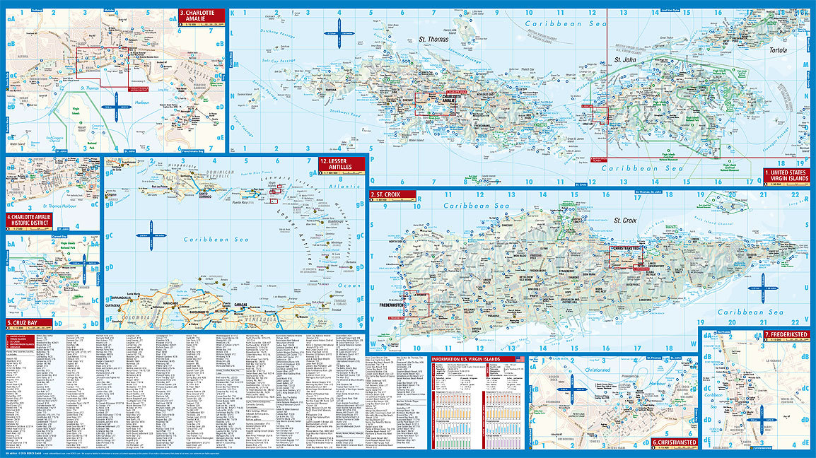
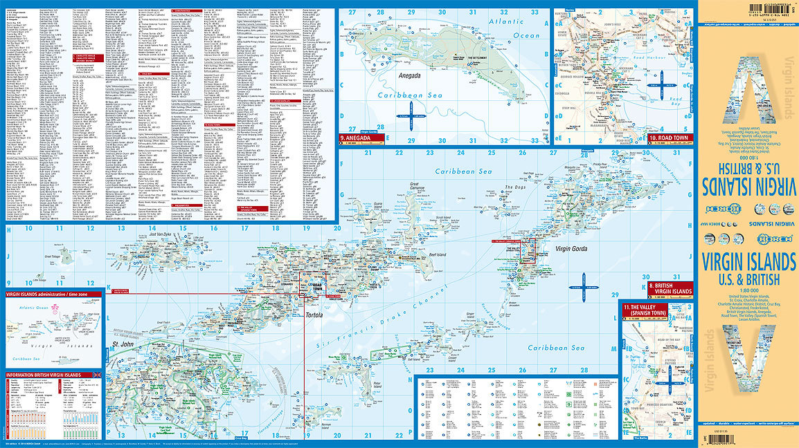
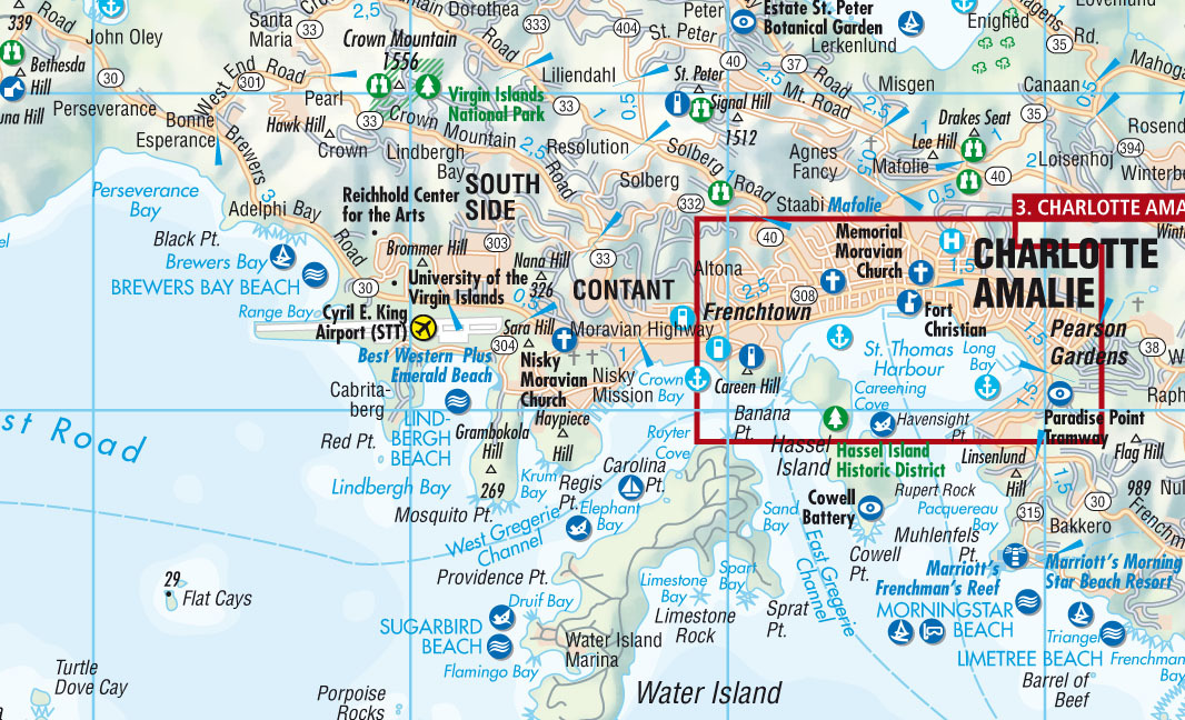
The soft-laminated map of the Virgin Islands includes: US Virgin Islands 1:80 000, St. Croix 1:80 000, Charlotte Amalie 1:15 000, Charlotte Amalie Historic District 1:7 500, Cruz Bay 1:15 000, Christiansted, Frederiksted 1:15 000, British Virgin Islands 1:80 000, Anegada 1:80 000, Road Town, The Valley (Spanish Town) 1:15 000, Lesser Antilles 1:7 000 000, Virgin Islands administrative / time zones; interesting statistics British / US Virgin Islands: conversion chart for temperatures, weights and measures; climate chart with temperatures, sunshine hours, precipitation and humidity; hotels, museums, markets and much more.
Virgin Islands is the name of two groups of small islands east of Puerto Rico which form the Virgin Islands archipelago. They lie between the Caribbean Sea and the Atlantic Ocean. One of the groups which consists of St. Croix, St. John and St. Thomas islands, together with many nearby islets, is called the U.S. Virgin Islands. The other group including Anegada, Jost van Dyke, Tortola, and Virgin Gorda islands, with their own surrounding islets, is known as the British Virgin Islands. The Virgin Islands are rugged and hilly, with little level land. They enjoy a delightful tropical climate the year round. Trade winds blow over the islands most of the year and there are no extremes of heat or cold. Hurricanes, however, may strike occasionally between July and November. Tropical flowers and trees flourish throughout the islands and the seas abound with fish. The excellent climate, the attractive beaches and the beautiful scenery make these islands a paradise worth visiting!
Unsere folienbeschichtete und gefaltete Borch Map der Britischen und Amerikanischen Jungferninseln in der 5. Auflage beinhaltet: die Amerikanischen Jungferninseln 1:80 000, St. Croix 1:80 000, Charlotte Amalie 1:15 000, Charlotte Amalie Historic District 1:7 500, Cruz Bay 1:15 000, Christiansted, Frederiksted 1:15 000, die Britischen Jungferninseln 1:80 000, Anegada 1:80 000, Road Town, The Valley (Spanish Town) 1:15 000, Kleine Antillen 1:7 000 000 und eine administrative Übersichtskarte der Jungferninseln mit Zeitzonen. Borch Maps beinhalten eine Vielzahl interessanter und nützlicher Informationen, detailreiche und benutzerfreundliche Kartographie, aber auch Statistiken, Umrechnungstabellen, Klimadiagramme und zahlreiche Übersichtskarten, die eine Borch Map zu einem exzellenten Reisebegleiter machen. Kartenformat (offen): 880 x 494 mm.
United States Virgin Islands, St. John, St. Thomas, St. Croix, Charlotte Amalie, Charlotte Amalie Historic District, Cruz Bay, Christiansted, Frederiksted - British Virgin Islands, Anegada, Virgin Gorda, Tortola, Jost van Dyke, The Valley
Reviews
Geen reviews gevonden voor dit product.
Schrijf een review
Graag horen wij wat u van dit artikel vindt. Vindt u het goed, leuk, mooi, slecht, lelijk, onbruikbaar of erg handig: schrijf gerust alles op! Het is niet alleen leuk om te doen maar u informeert andere klanten er ook nog mee!
Alle gerelateerde rubrieken >
Ook interessant voor midden-amerika/maagden-eilanden
-

Reisgids U.S. & British Virgin Islan
€ 20,95Reisgidsen Maagden Eilanden -

Waterkaart Fish Card Caribbean Sea D
€ 7,95Waterkaarten Aruba -

Wegenkaart - landkaart US Virgin Isl
€ 14,95Wegenkaarten Maagden Eilanden -

Vogelgids Birds of the West Indies |
€ 55,00Vogelgidsen Antigua -

Reisgids Experience US & British Vir
€ 26,95Reisgidsen Maagden Eilanden