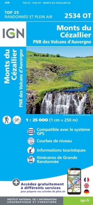
Wandelkaart - Topografische kaart 2534OT Monts du Cezallier, Condat, Allanche, Parc Volcans d'Auvergne | IGN - Institut Géographique National (9782758545378)
- ISBN / CODE: 9782758545378
- Editie: nieuwste editie
- Schaal: 1:25000
- Uitgever: IGN - Institut Géographique National
- Soort: Topografische kaart, Wandelkaart
- Serie: Top 25
- Taal: Frans
- Bindwijze: -
- Uitvoering: Papier
- Schrijf als eerste een review
-
€ 16,95
Op voorraad. Voor 17.00 uur op werkdagen besteld, morgen in huis in Nederland Levertijd Belgie
Gratis verzending in Nederland vanaf €35,-

.jpg)
-
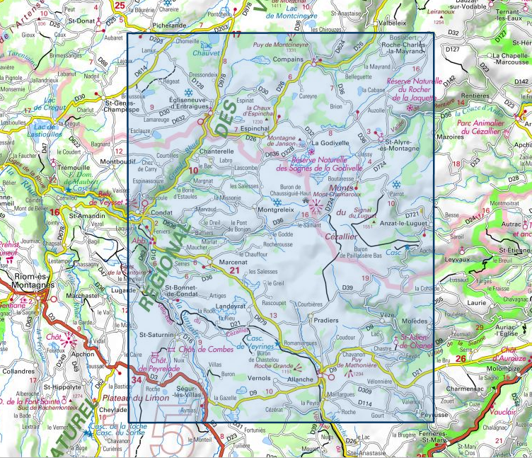
Topografische kaarten IGN 25.000 Auvergne : Noord


Producten op deze overzichtskaart:
Klik op een product om naar de pagina van dat product te gaan.
- Wandelkaart - Topografische kaart 2327SB Culan - Châteaumeillant | IGN - Institut Géographique National
- Wandelkaart - Topografische kaart 2328SB Huriel - Boussac | IGN - Institut Géographique National
- Wandelkaart - Topografische kaart 2329SB Évaux-les-Bains | IGN - Institut Géographique National
- Wandelkaart - Topografische kaart 2330SB Auzances - Aubusson | IGN - Institut Géographique National
- Wandelkaart - Topografische kaart 2331SB Felletin | IGN - Institut Géographique National
- Wandelkaart - Topografische kaart 2332SB Ussel | IGN - Institut Géographique National
- Wandelkaart - Topografische kaart 2333SB Bort-les-Orgues | IGN - Institut Géographique National
- Wandelkaart - Topografische kaart 2334SB Mauriac | IGN - Institut Géographique National
- Topografische kaart - Wandelkaart 2427SB Cérilly | IGN - Institut Géographique National
- Wandelkaart - Topografische kaart 2428SB Montluçon | IGN - Institut Géographique National
- Wandelkaart - Topografische kaart 2429SB Saint-Éloy-les-Mines | IGN - Institut Géographique National
- Wandelkaart - Topografische kaart 2430SB Saint-Gervais d'Auvergne | IGN - Institut Géographique National
- Wandelkaart - Topografische kaart 2431SB Pontaumur | IGN - Institut Géographique National
- Wandelkaart - Topografische kaart 2432ET Massif du Sancy | IGN - Institut Géographique National
- Topografische kaart - Wandelkaart 2433SB la Bourboule | IGN - Institut Géographique National
- Wandelkaart - Topografische kaart 2434OT Riom es Montagnes, Bort-les-Orgues, PNR des Volcans d'Auvergne | IGN - Institut Géographique National
- Topografische kaart - Wandelkaart 2527SB Bourbon-l'Archambault | IGN - Institut Géographique National
- Wandelkaart - Topografische kaart 2528SB Tronget - Montmarault | IGN - Institut Géographique National
- Wandelkaart - Topografische kaart 2529SB Gannat | IGN - Institut Géographique National
- Wandelkaart - Topografische kaart 2530SB Aigueperse, Châtel-Guyon, Manzat | IGN - Institut Géographique National
- Wandelkaart - Topografische kaart 2531ET Chaîne des Puys | IGN - Institut Géographique National
- Wandelkaart - Topografische kaart 2531SB Clermont-Ferrand | IGN - Institut Géographique National
- Wandelkaart - Topografische kaart 2532SB Veyre-Monton, Issoire | IGN - Institut Géographique National
- Wandelkaart - Topografische kaart 2534OT Monts du Cezallier, Condat, Allanche, Parc Volcans d'Auvergne | IGN - Institut Géographique National
- Wandelkaart - Topografische kaart 2534SB Massiac - Ardes | IGN - Institut Géographique National
- Wandelkaart - Topografische kaart 2631SB Thiers | IGN - Institut Géographique National
- Wandelkaart - Topografische kaart 2632SB Issoire | IGN - Institut Géographique National
- Wandelkaart - Topografische kaart 2633SB St-Germain-l'Herm, Brassac-les-Mines | IGN - Institut Géographique National
- Wandelkaart - Topografische kaart 2634SB Paulhaguet - Brioude | IGN - Institut Géographique National
- Wandelkaart - Topografische kaart 2731SB Noirétable | IGN - Institut Géographique National
- Wandelkaart - Topografische kaart 2732SB Ambert | IGN - Institut Géographique National
- Wandelkaart - Topografische kaart 2734SB Allègre, La Chaise-Dieu, Craponne-sur-Arzon | IGN - Institut Géographique National
-
Wandelkaarten IGN 25.000 Auvergne : Noord

Producten op deze overzichtskaart:
Klik op een product om naar de pagina van dat product te gaan.
- Wandelkaart - Topografische kaart 2327SB Culan - Châteaumeillant | IGN - Institut Géographique National
- Wandelkaart - Topografische kaart 2328SB Huriel - Boussac | IGN - Institut Géographique National
- Wandelkaart - Topografische kaart 2329SB Évaux-les-Bains | IGN - Institut Géographique National
- Wandelkaart - Topografische kaart 2330SB Auzances - Aubusson | IGN - Institut Géographique National
- Wandelkaart - Topografische kaart 2331SB Felletin | IGN - Institut Géographique National
- Wandelkaart - Topografische kaart 2332SB Ussel | IGN - Institut Géographique National
- Wandelkaart - Topografische kaart 2333SB Bort-les-Orgues | IGN - Institut Géographique National
- Wandelkaart - Topografische kaart 2334SB Mauriac | IGN - Institut Géographique National
- Topografische kaart - Wandelkaart 2427SB Cérilly | IGN - Institut Géographique National
- Wandelkaart - Topografische kaart 2428SB Montluçon | IGN - Institut Géographique National
- Wandelkaart - Topografische kaart 2429SB Saint-Éloy-les-Mines | IGN - Institut Géographique National
- Wandelkaart - Topografische kaart 2430SB Saint-Gervais d'Auvergne | IGN - Institut Géographique National
- Wandelkaart - Topografische kaart 2431SB Pontaumur | IGN - Institut Géographique National
- Wandelkaart - Topografische kaart 2432ET Massif du Sancy | IGN - Institut Géographique National
- Topografische kaart - Wandelkaart 2433SB la Bourboule | IGN - Institut Géographique National
- Wandelkaart - Topografische kaart 2434OT Riom es Montagnes, Bort-les-Orgues, PNR des Volcans d'Auvergne | IGN - Institut Géographique National
- Topografische kaart - Wandelkaart 2527SB Bourbon-l'Archambault | IGN - Institut Géographique National
- Wandelkaart - Topografische kaart 2528SB Tronget - Montmarault | IGN - Institut Géographique National
- Wandelkaart - Topografische kaart 2529SB Gannat | IGN - Institut Géographique National
- Wandelkaart - Topografische kaart 2530SB Aigueperse, Châtel-Guyon, Manzat | IGN - Institut Géographique National
- Wandelkaart - Topografische kaart 2531ET Chaîne des Puys | IGN - Institut Géographique National
- Wandelkaart - Topografische kaart 2531SB Clermont-Ferrand | IGN - Institut Géographique National
- Wandelkaart - Topografische kaart 2532SB Veyre-Monton, Issoire | IGN - Institut Géographique National
- Wandelkaart - Topografische kaart 2534OT Monts du Cezallier, Condat, Allanche, Parc Volcans d'Auvergne | IGN - Institut Géographique National
- Wandelkaart - Topografische kaart 2534SB Massiac - Ardes | IGN - Institut Géographique National
- Wandelkaart - Topografische kaart 2631SB Thiers | IGN - Institut Géographique National
- Wandelkaart - Topografische kaart 2632SB Issoire | IGN - Institut Géographique National
- Wandelkaart - Topografische kaart 2633SB St-Germain-l'Herm, Brassac-les-Mines | IGN - Institut Géographique National
- Wandelkaart - Topografische kaart 2634SB Paulhaguet - Brioude | IGN - Institut Géographique National
- Wandelkaart - Topografische kaart 2731SB Noirétable | IGN - Institut Géographique National
- Wandelkaart - Topografische kaart 2732SB Ambert | IGN - Institut Géographique National
- Wandelkaart - Topografische kaart 2734SB Allègre, La Chaise-Dieu, Craponne-sur-Arzon | IGN - Institut Géographique National
Overzichtskaarten
Beschrijving
De wandelkaart die de perfectie benadert! Werkelijk alle topografische details zijn er op te vinden; van hoogtelijnen tot aan bruggetjes en allerlei wandelpaden. Daarnaast hebben de makers een flinke dosis toeristische informatie op de kaart verwerkt: campings, gites d étape, restaurants en ingetekende doorgaande wandelpaden, de grandes randonnées. Het kleurgebruik is geweldig met schaduwzijdes, bos, weiland, etc goed te onderscheiden. De kaart is uitgevoerd met raster van graden, dus deze is GPS - toepasbaar!
Reviews
Geen reviews gevonden voor dit product.
Schrijf een review
Graag horen wij wat u van dit artikel vindt. Vindt u het goed, leuk, mooi, slecht, lelijk, onbruikbaar of erg handig: schrijf gerust alles op! Het is niet alleen leuk om te doen maar u informeert andere klanten er ook nog mee!
Ook interessant voor europa/frankrijk/auvergne-rhone-alpes/auvergne
-

Wandelgids 304 Volcans et lacs d'Auv
€ 21,95Wandelgidsen Auvergne -

Wandelkaart - Topografische kaart 23
€ 16,95Topografische kaarten Auvergne -

Wandelgids P032 Le Val de Sioule à p
€ 18,50Wandelgidsen Auvergne -

Wandelgids 400 Volcan du Cantal - Pa
€ 19,95Wandelgidsen Auvergne -

Wandelkaart - Topografische kaart 24
€ 16,95Topografische kaarten Auvergne