Winkelwagen
Geen items in winkelwagen
Ga naar winkelwagen
Topografische kaarten - Cevennen
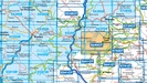
Overzichtskaarten
-
Topografische kaarten IGN 25.000 Cevennen
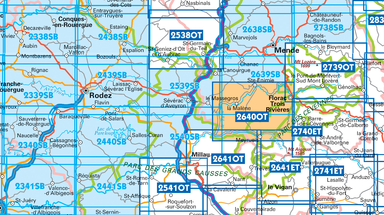
Producten op deze overzichtskaart:
Klik op een product om naar de pagina van dat product te gaan.
- Wandelkaart - Topografische kaart 2241SB Albi, Cordes-sur-Ciel | IGN - Institut Géographique National
- Wandelkaart - Topografische kaart 2338SB Decazeville | IGN - Institut Géographique National
- Wandelkaart - Topografische kaart 2339SB Rieupeyroux - Moyrazes | IGN - Institut Géographique National
- Wandelkaart - Topografische kaart 2340SB Naucelle, La Salvetat, Peyrales | IGN - Institut Géographique National
- Wandelkaart - Topografische kaart 2341SB Carmaux, Valence-d'Albigeoi | IGN - Institut Géographique National
- Wandelkaart - Topografische kaart 2438SB Espalion - Estaing | IGN - Institut Géographique National
- Wandelkaart - Topografische kaart 2439SB Rodez - Laissac | IGN - Institut Géographique National
- Wandelkaart - Topografische kaart 2440SB Salles-Curan, Lac de Pareloup, Cassagnes, Begonhes | IGN - Institut Géographique National
- Wandelkaart - Topografische kaart 2441SB Réquista, Villefranche-de-Panat | IGN - Institut Géographique National
- Wandelkaart - Topografische kaart 2538OT Ste-Eulalie-d'Olt - Hte Vallée du Lot - Mt d'Aubrac | IGN - Institut Géographique National
- Wandelkaart - Topografische kaart 2539SB Sévérac-le-Château, Lapanouse | IGN - Institut Géographique National
- Wandelkaart - Topografische kaart 2540SB St-Beauzély, Aguessac, Gorges-du-Tarn | IGN - Institut Géographique National
- Wandelkaart - Topografische kaart 2541OT Millau, St-Affrique - PNR Grands Causses | IGN - Institut Géographique National
- Wandelkaart - Topografische kaart 2638SB Mende | IGN - Institut Géographique National
- Wandelkaart - Topografische kaart 2639SB Florac | IGN - Institut Géographique National
- Wandelkaart - Topografische kaart 2640OT Gorges du Tarn et de la Jonte | IGN - Institut Géographique National
- Wandelkaart - Topografische kaart 2641ET Mont Aigoual | IGN - Institut Géographique National
- Wandelkaart - Topografische kaart 2641OT Millau | IGN - Institut Géographique National
- Wandelkaart - Topografische kaart 2738SB Le Bleymard | IGN - Institut Géographique National
- Wandelkaart - Topografische kaart 2739OT Mont Lozère - Florac | IGN - Institut Géographique National
- Wandelkaart - Topografische kaart 2740ET Corniche des Cevennes | IGN - Institut Géographique National
- Wandelkaart - Topografische kaart 2741ET Saint-Hippolyte-du-Fort | IGN - Institut Géographique National
 Wandelkaart - Topografische kaart 2338SB Decazeville | IGN - Institut Géographique National
 Wandelkaart - Topografische kaart 2438SB Espalion - Estaing | IGN - Institut Géographique National
 Wandelkaart - Topografische kaart 2638SB Mende | IGN - Institut Géographique National
 Wandelkaart - Topografische kaart 2738SB Le Bleymard | IGN - Institut Géographique National
 Wandelkaart - Topografische kaart 2339SB Rieupeyroux - Moyrazes | IGN - Institut Géographique National
 Wandelkaart - Topografische kaart 2439SB Rodez - Laissac | IGN - Institut Géographique National
 Wandelkaart - Topografische kaart 2539SB Sévérac-le-Château, Lapanouse | IGN - Institut Géographique National
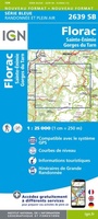 Wandelkaart - Topografische kaart 2639SB Florac | IGN - Institut Géographique National
 Wandelkaart - Topografische kaart 2440SB Salles-Curan, Lac de Pareloup, Cassagnes, Begonhes | IGN - Institut Géographique National
 Wandelkaart - Topografische kaart 2540SB St-Beauzély, Aguessac, Gorges-du-Tarn | IGN - Institut Géographique National
 Wandelkaart - Topografische kaart 2441SB Réquista, Villefranche-de-Panat | IGN - Institut Géographique National★★★★★
 Wandelkaart - Topografische kaart 2541OT Millau, St-Affrique - PNR Grands Causses | IGN - Institut Géographique National
 Wandelkaart - Topografische kaart 2641OT Millau | IGN - Institut Géographique National★★★★★
 Wandelkaart - Topografische kaart 2640OT Gorges du Tarn et de la Jonte | IGN - Institut Géographique National★★★★★
 Wandelkaart - Topografische kaart 2641ET Mont Aigoual | IGN - Institut Géographique National
 Wandelkaart - Topografische kaart 2642ET St.-Guilhem-le-Desert | IGN - Institut Géographique National
 Wandelkaart - Topografische kaart 2739OT Mont Lozère - Florac | IGN - Institut Géographique National★★★★★
 Wandelkaart - Topografische kaart 2740ET Corniche des Cevennes | IGN - Institut Géographique National
 Wandelkaart - Topografische kaart 2741ET Saint-Hippolyte-du-Fort | IGN - Institut Géographique National
 Wandelkaart - Topografische kaart 2839OT Besseges - Les-Vans | IGN - Institut Géographique National
Laatste reviews

Duidelijk en overzichtelijk
Fijne wegenkaart, alleen jammer dat dergelijke kaarten niet van een zodanige papiersoort worden vervaardigd, dat ze niet zo snel scheuren op de naden.
★★★★★ door Inge Stegeman 01 mei 2024 | Heeft dit artikel gekocht
Leek het meest op wat ik graag zou willen
Duidelijke en gedetailleerde plattegrond; goede aanvulling op google maps die noodzakelijkerwijs op postzegelformaat zijn. Er is wel een flink tafelblad nodig om hem uit te …
★★★★★ door Arjen Florijn 01 mei 2024 | Heeft dit artikel gekocht
Product is top, zeer zorgvuldig verzonden.
De politieke wandkaart siert de wand, we reizen vanaf de bank mee met ons lieve familie.
★★★★★ door Willy Regter 01 mei 2024 | Heeft dit artikel gekocht
Fijne gedetailleerde wegenatlas met zowel essentiële als leuke informatie.
De atlas geeft de noodzakelijke wegeninformatie op een gedetailleerde schaal, zodat je je goed kunt oriënteren op de vaak lange, soms saaie trajecten. Betrouwbare gegevens …
★★★★★ door D. Van der Maas 01 mei 2024 | Heeft dit artikel gekocht