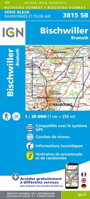
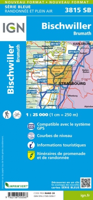
Wandelkaart - Topografische kaart 3815SB Bischwiller - Brumath | IGN - Institut Géographique National (9782758550587)
- ISBN / CODE: 9782758550587
- Editie: meest recente versie
- Schaal: 1:25000
- Uitgever: IGN - Institut Géographique National
- Soort: Topografische kaart, Wandelkaart
- Serie: Serie bleue
- Taal: Engels, Frans
- Schrijf als eerste een review
-
€ 16,95
Dit artikel is (tijdelijk) niet leverbaar
-
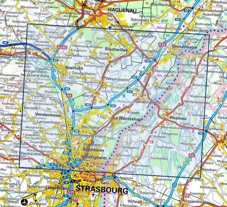
Overzicht IGN 25.000 Vogezen en Elzas - Lotharingen: Oost

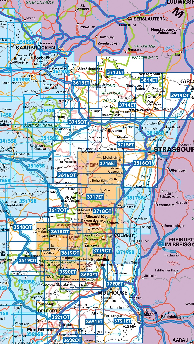
Producten op deze overzichtskaart:
Klik op een product om naar de pagina van dat product te gaan.
- Wandelkaart - Topografische kaart 3518OT Epinal | IGN - Institut Géographique National
- Wandelkaart - Topografische kaart 3519OT Remiremont | IGN - Institut Géographique National
- Wandelkaart - Topografische kaart 3520ET Ballon d'Alsace | IGN - Institut Géographique National
- Wandelkaart - Topografische kaart 3613ET Sarreguemines | IGN - Institut Géographique National
- Wandelkaart - Topografische kaart 3614ET Sarre-Union - Phalsbourg | IGN - Institut Géographique National
- Wandelkaart - Topografische kaart 3616OT Lac de Pierre-Percée - Le Donon | IGN - Institut Géographique National
- Wandelkaart - Topografische kaart 3617OT St-Dié-des-Vosges | IGN - Institut Géographique National
- Wandelkaart - Topografische kaart 3618OT Le Hohneck - Gérardmer | IGN - Institut Géographique National
- Wandelkaart - Topografische kaart 3619OT Bussang - La Bresse | IGN - Institut Géographique National
- Wandelkaart - Topografische kaart 3620ET Grand Ballon | IGN - Institut Géographique National
- Wandelkaart - Topografische kaart 3621ET Dannemarie - Delle - Sundgau | IGN - Institut Géographique National
- Wandelkaart - Topografische kaart 3713ET Pays de Bitche - Dambach - PNR des Vosges du Nord | IGN - Institut Géographique National
- Wandelkaart - Topografische kaart 3714ET la Petite Pierre - Petite Pierre, Niederbronn-les-Bains, PNR Vosges du Nord | IGN - Institut Géographique National
- Wandelkaart - Topografische kaart 3715ET Wasselone - Rocher de Dabo - Saverne | IGN - Institut Géographique National
- Wandelkaart - Topografische kaart 3715OT Sarrebourg - Phalsbourg - Pays des Etangs | IGN - Institut Géographique National
- Wandelkaart - Topografische kaart 3716ET le Donon, Obernai, Mont Ste-Odile | IGN - Institut Géographique National
- Wandelkaart - Topografische kaart 3717ET Barr - Le Howald - Villé - Vallée de la Bruche | IGN - Institut Géographique National
- Wandelkaart - Topografische kaart 3718OT Selestat - Col Du Bonhomme | IGN - Institut Géographique National
- Wandelkaart - Topografische kaart 3719OT Colmar & Le Hohneck | IGN - Institut Géographique National
- Wandelkaart - Topografische kaart 3719SB Colmar | IGN - Institut Géographique National
- Wandelkaart - Topografische kaart 3720ET Mulhouse | IGN - Institut Géographique National
- Wandelkaart - Topografische kaart 3721ET Altkirch - Bâle - Sundgau | IGN - Institut Géographique National
- Wandelkaart - Topografische kaart 3814ET Hagenau - Lembach - PNR des Vosges du Nord | IGN - Institut Géographique National
- Wandelkaart - Topografische kaart 3815SB Bischwiller - Brumath | IGN - Institut Géographique National
- Wandelkaart - Topografische kaart 3816OT Strasbourg | IGN - Institut Géographique National
- Wandelkaart - Topografische kaart 3817SB Sélestat - Marckolsheim | IGN - Institut Géographique National
- Wandelkaart - Topografische kaart 3914OT Wissembourg | IGN - Institut Géographique National
-
Overzicht IGN 25.000 Vogezen en Elzas - Lotharingen: Oost

Producten op deze overzichtskaart:
Klik op een product om naar de pagina van dat product te gaan.
- Wandelkaart - Topografische kaart 3518OT Epinal | IGN - Institut Géographique National
- Wandelkaart - Topografische kaart 3519OT Remiremont | IGN - Institut Géographique National
- Wandelkaart - Topografische kaart 3520ET Ballon d'Alsace | IGN - Institut Géographique National
- Wandelkaart - Topografische kaart 3613ET Sarreguemines | IGN - Institut Géographique National
- Wandelkaart - Topografische kaart 3614ET Sarre-Union - Phalsbourg | IGN - Institut Géographique National
- Wandelkaart - Topografische kaart 3616OT Lac de Pierre-Percée - Le Donon | IGN - Institut Géographique National
- Wandelkaart - Topografische kaart 3617OT St-Dié-des-Vosges | IGN - Institut Géographique National
- Wandelkaart - Topografische kaart 3618OT Le Hohneck - Gérardmer | IGN - Institut Géographique National
- Wandelkaart - Topografische kaart 3619OT Bussang - La Bresse | IGN - Institut Géographique National
- Wandelkaart - Topografische kaart 3620ET Grand Ballon | IGN - Institut Géographique National
- Wandelkaart - Topografische kaart 3621ET Dannemarie - Delle - Sundgau | IGN - Institut Géographique National
- Wandelkaart - Topografische kaart 3713ET Pays de Bitche - Dambach - PNR des Vosges du Nord | IGN - Institut Géographique National
- Wandelkaart - Topografische kaart 3714ET la Petite Pierre - Petite Pierre, Niederbronn-les-Bains, PNR Vosges du Nord | IGN - Institut Géographique National
- Wandelkaart - Topografische kaart 3715ET Wasselone - Rocher de Dabo - Saverne | IGN - Institut Géographique National
- Wandelkaart - Topografische kaart 3715OT Sarrebourg - Phalsbourg - Pays des Etangs | IGN - Institut Géographique National
- Wandelkaart - Topografische kaart 3716ET le Donon, Obernai, Mont Ste-Odile | IGN - Institut Géographique National
- Wandelkaart - Topografische kaart 3717ET Barr - Le Howald - Villé - Vallée de la Bruche | IGN - Institut Géographique National
- Wandelkaart - Topografische kaart 3718OT Selestat - Col Du Bonhomme | IGN - Institut Géographique National
- Wandelkaart - Topografische kaart 3719OT Colmar & Le Hohneck | IGN - Institut Géographique National
- Wandelkaart - Topografische kaart 3719SB Colmar | IGN - Institut Géographique National
- Wandelkaart - Topografische kaart 3720ET Mulhouse | IGN - Institut Géographique National
- Wandelkaart - Topografische kaart 3721ET Altkirch - Bâle - Sundgau | IGN - Institut Géographique National
- Wandelkaart - Topografische kaart 3814ET Hagenau - Lembach - PNR des Vosges du Nord | IGN - Institut Géographique National
- Wandelkaart - Topografische kaart 3815SB Bischwiller - Brumath | IGN - Institut Géographique National
- Wandelkaart - Topografische kaart 3816OT Strasbourg | IGN - Institut Géographique National
- Wandelkaart - Topografische kaart 3817SB Sélestat - Marckolsheim | IGN - Institut Géographique National
- Wandelkaart - Topografische kaart 3914OT Wissembourg | IGN - Institut Géographique National
Overzichtskaarten
Beschrijving
Een nieuwe serie van IGN: de oude versies Est en Ouest (E en O aanduiding achter het nummer van de kaart) gaan verdwijnen en worden vervangen door een kaart met nummer en gevolgd door de letters SB. In de meeste gevalen is het een samenvoeging van de E en O kaart, de SB kaart beslaat dan ook een groter gebied. Het gebied bestrijkt ongeveer 28 x 20 km.
Reviews
Geen reviews gevonden voor dit product.
Schrijf een review
Graag horen wij wat u van dit artikel vindt. Vindt u het goed, leuk, mooi, slecht, lelijk, onbruikbaar of erg handig: schrijf gerust alles op! Het is niet alleen leuk om te doen maar u informeert andere klanten er ook nog mee!
Ook interessant voor europa/frankrijk/vogezen-elzas
-

Campergids 06 Mit dem Wohnmobil ins
€ 22,95Campergidsen Vogezen - Elzas - Lotharingen -

Reisgids Michelin groene gids Elzas
€ 25,99Reisgidsen Vogezen - Elzas - Lotharingen -

Wegenkaart - landkaart 314 Haute Sao
€ 9,95Wegenkaarten Vogezen - Elzas - Lotharingen -

Fietsgids Bikeline Mosel-Radweg Fran
€ 15,50Fietsgidsen Vogezen - Elzas - Lotharingen -

Wandelkaart - Topografische kaart 36
€ 16,95Topografische kaarten Vogezen - Elzas - Lotharingen