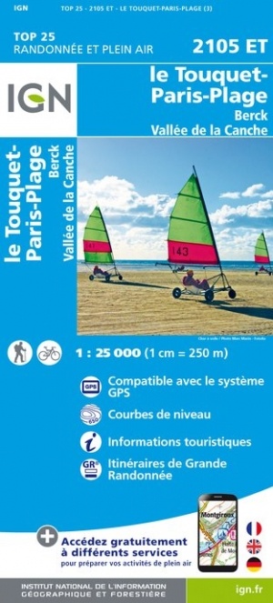
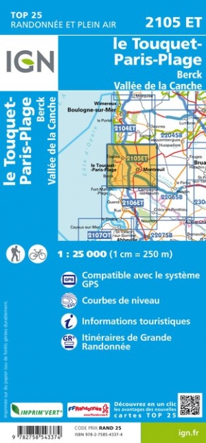
Wandelkaart - Topografische kaart 2105ET Le Touquet-Paris-Plage, Berck, Étaples, Vallée de la Canche | IGN - Institut Géographique National (9782758543374)
- ISBN / CODE: 9782758543374
- Editie: meest recente editie
- Schaal: 1:25000
- Uitgever: IGN - Institut Géographique National
- Soort: Topografische kaart, Wandelkaart
- Serie: Top 25
- Taal: Frans
- Cartografie: topografisch
- Uitvoering: Papier
- Bindwijze: -
- Schrijf als eerste een review
-
€ 16,95
Leverbaar in 3 - 5 werkdagen in huis in Nederland Levertijd Belgie
Gratis verzending in Nederland vanaf €35,-
-
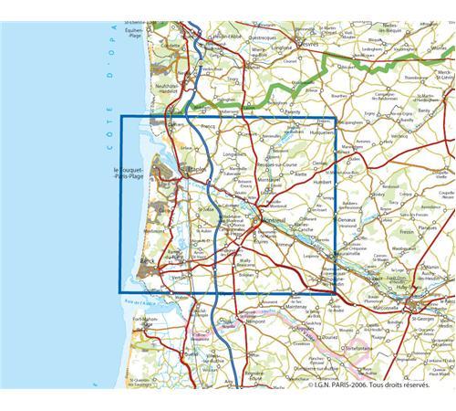
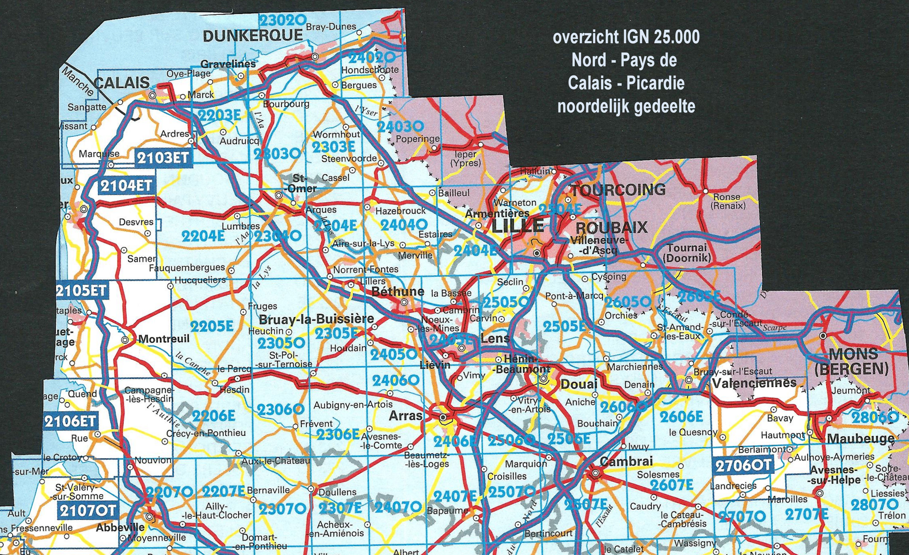
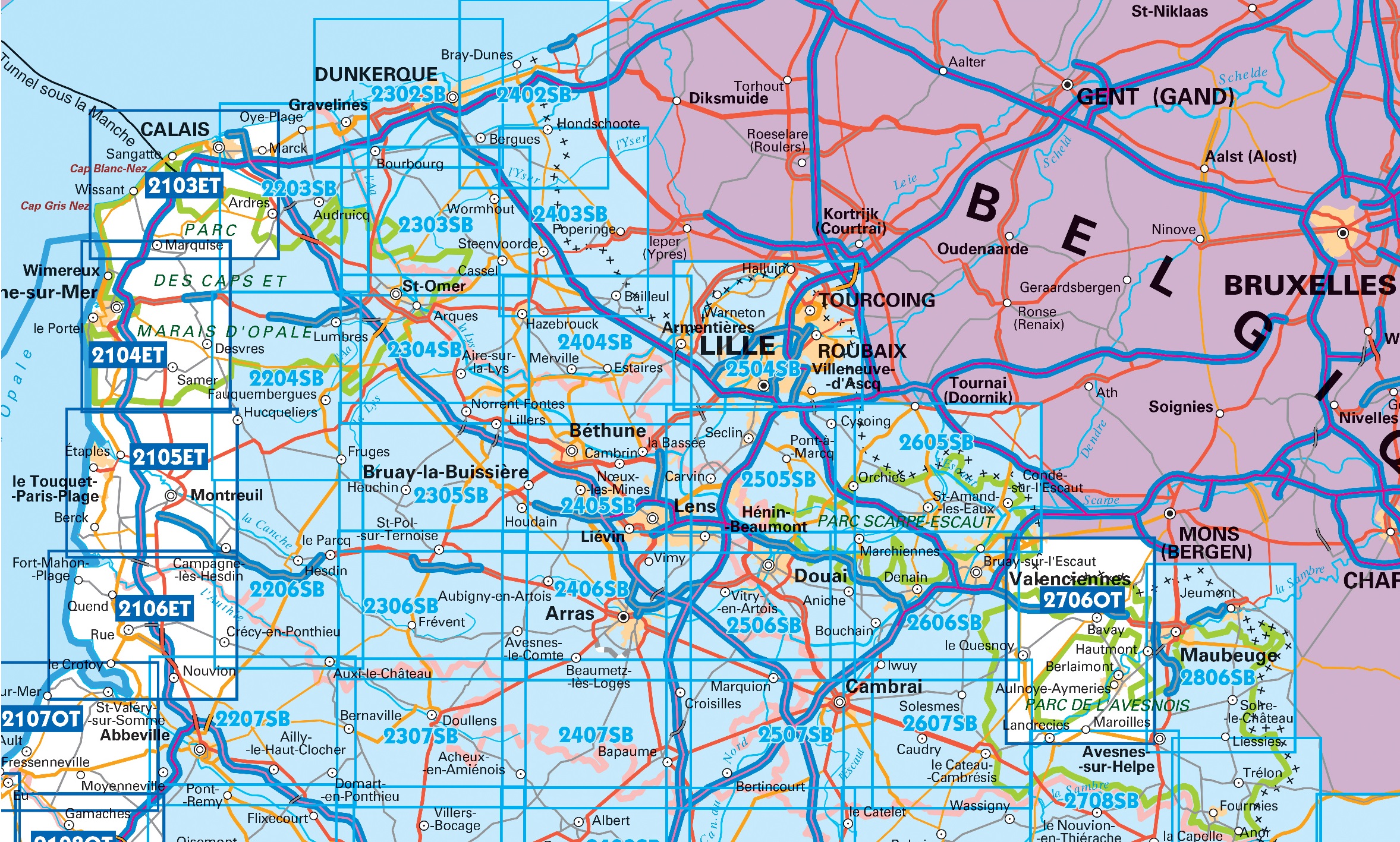
Overzicht IGN 25.000 Pays de Calais - Picardië: Noord


Producten op deze overzichtskaart:
Klik op een product om naar de pagina van dat product te gaan.
- Wandelkaart - Topografische kaart 2103ET Calais | IGN - Institut Géographique National
- Wandelkaart - Topografische kaart 2104ET Boulogne-Sur-Mer | IGN - Institut Géographique National
- Wandelkaart - Topografische kaart 2105ET Le Touquet-Paris-Plage, Berck, Étaples, Vallée de la Canche | IGN - Institut Géographique National
- Wandelkaart - Topografische kaart 2106ET Baie de Somme, Le Crotoy, Fort-Mahon-Plage | IGN - Institut Géographique National
- Wandelkaart - Topografische kaart 2107OT Le Tréport | IGN - Institut Géographique National
- Wandelkaart - Topografische kaart 2203SB Gravelines - Andruicq | IGN - Institut Géographique National
- Wandelkaart - Topografische kaart 2204SB Lumbres - Fruges | IGN - Institut Géographique National
- Wandelkaart - Topografische kaart 2206SB Hesdin, Auxi-le-Château | IGN - Institut Géographique National
- Wandelkaart - Topografische kaart 2207SB Abbeville, Domart-en-Ponthieu | IGN - Institut Géographique National
- Topografische kaart - Wandelkaart 2302SB Dunkerque - Gravelines | IGN - Institut Géographique National
- Wandelkaart - Topografische kaart 2303SB Wormhout - Cassel - Watten | IGN - Institut Géographique National
- Wandelkaart - Topografische kaart 2304SB Aire-Sur-La-Lys, St-Omer | IGN - Institut Géographique National
- Wandelkaart - Topografische kaart 2305SB Lillers - Heuchin | IGN - Institut Géographique National
- Wandelkaart - Topografische kaart 2306SB Saint-Michel-Sur-Ternoise, Frévent | IGN - Institut Géographique National
- Wandelkaart - Topografische kaart 2307SB Doullens - Beauval | IGN - Institut Géographique National
- Wandelkaart - Topografische kaart 2402SB Hondschoote - Bergues | IGN - Institut Géographique National
- Wandelkaart - Topografische kaart 2403SB Steenvoorde - Bailleul | IGN - Institut Géographique National
- Wandelkaart - Topografische kaart 2404SB Armentieres - Hazebrouck | IGN - Institut Géographique National
- Wandelkaart - Topografische kaart 2405SB Lens - Béthune | IGN - Institut Géographique National
- Wandelkaart - Topografische kaart 2406SB Arras, Avesnes-le-Comte | IGN - Institut Géographique National
- Wandelkaart - Topografische kaart 2407SB Bapaume, Acheux-en-Amiénois | IGN - Institut Géographique National
- Wandelkaart - Topografische kaart 2504SB Lille - Roubaix - Tourcoing | IGN - Institut Géographique National
- Wandelkaart - Topografische kaart 2505SB Leforest - Cysoing - Hénin-Beaumont - Carvin | IGN - Institut Géographique National
- Wandelkaart - Topografische kaart 2506SB Douai - Rouvroy - Vitry-en-Artois | IGN - Institut Géographique National
- Wandelkaart - Topografische kaart 2507SB Cambrai - Bertincourt | IGN - Institut Géographique National
- Wandelkaart - Topografische kaart 2606SB Valenciennes - Denain | IGN - Institut Géographique National
- Wandelkaart - Topografische kaart 2607SB Le Cateau-Cambrésis, Caudry | IGN - Institut Géographique National
- Wandelkaart - Topografische kaart 2706OT Foret De Mormal | IGN - Institut Géographique National
- Wandelkaart - Topografische kaart 2806SB Jeumont - Maubeuge | IGN - Institut Géographique National
-
Overzicht IGN 25.000 Pays de Calais - Picardië: Noord
Producten op deze overzichtskaart:
Klik op een product om naar de pagina van dat product te gaan.
- Wandelkaart - Topografische kaart 2103ET Calais | IGN - Institut Géographique National
- Wandelkaart - Topografische kaart 2104ET Boulogne-Sur-Mer | IGN - Institut Géographique National
- Wandelkaart - Topografische kaart 2105ET Le Touquet-Paris-Plage, Berck, Étaples, Vallée de la Canche | IGN - Institut Géographique National
- Wandelkaart - Topografische kaart 2106ET Baie de Somme, Le Crotoy, Fort-Mahon-Plage | IGN - Institut Géographique National
- Wandelkaart - Topografische kaart 2107OT Le Tréport | IGN - Institut Géographique National
- Wandelkaart - Topografische kaart 2203SB Gravelines - Andruicq | IGN - Institut Géographique National
- Wandelkaart - Topografische kaart 2204SB Lumbres - Fruges | IGN - Institut Géographique National
- Wandelkaart - Topografische kaart 2206SB Hesdin, Auxi-le-Château | IGN - Institut Géographique National
- Wandelkaart - Topografische kaart 2207SB Abbeville, Domart-en-Ponthieu | IGN - Institut Géographique National
- Topografische kaart - Wandelkaart 2302SB Dunkerque - Gravelines | IGN - Institut Géographique National
- Wandelkaart - Topografische kaart 2303SB Wormhout - Cassel - Watten | IGN - Institut Géographique National
- Wandelkaart - Topografische kaart 2304SB Aire-Sur-La-Lys, St-Omer | IGN - Institut Géographique National
- Wandelkaart - Topografische kaart 2305SB Lillers - Heuchin | IGN - Institut Géographique National
- Wandelkaart - Topografische kaart 2306SB Saint-Michel-Sur-Ternoise, Frévent | IGN - Institut Géographique National
- Wandelkaart - Topografische kaart 2307SB Doullens - Beauval | IGN - Institut Géographique National
- Wandelkaart - Topografische kaart 2402SB Hondschoote - Bergues | IGN - Institut Géographique National
- Wandelkaart - Topografische kaart 2403SB Steenvoorde - Bailleul | IGN - Institut Géographique National
- Wandelkaart - Topografische kaart 2404SB Armentieres - Hazebrouck | IGN - Institut Géographique National
- Wandelkaart - Topografische kaart 2405SB Lens - Béthune | IGN - Institut Géographique National
- Wandelkaart - Topografische kaart 2406SB Arras, Avesnes-le-Comte | IGN - Institut Géographique National
- Wandelkaart - Topografische kaart 2407SB Bapaume, Acheux-en-Amiénois | IGN - Institut Géographique National
- Wandelkaart - Topografische kaart 2504SB Lille - Roubaix - Tourcoing | IGN - Institut Géographique National
- Wandelkaart - Topografische kaart 2505SB Leforest - Cysoing - Hénin-Beaumont - Carvin | IGN - Institut Géographique National
- Wandelkaart - Topografische kaart 2506SB Douai - Rouvroy - Vitry-en-Artois | IGN - Institut Géographique National
- Wandelkaart - Topografische kaart 2507SB Cambrai - Bertincourt | IGN - Institut Géographique National
- Wandelkaart - Topografische kaart 2606SB Valenciennes - Denain | IGN - Institut Géographique National
- Wandelkaart - Topografische kaart 2607SB Le Cateau-Cambrésis, Caudry | IGN - Institut Géographique National
- Wandelkaart - Topografische kaart 2706OT Foret De Mormal | IGN - Institut Géographique National
- Wandelkaart - Topografische kaart 2806SB Jeumont - Maubeuge | IGN - Institut Géographique National
Overzichtskaarten
Beschrijving
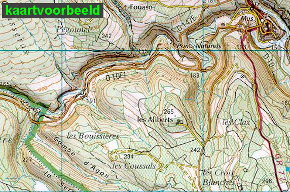
De wandelkaart die de perfectie benadert! Werkelijk alle topografische details zijn er op te vinden; van hoogtelijnen tot aan bruggetjes en allerlei wandelpaden. Daarnaast hebben de makers een flinke dosis toeristische informatie op de kaart verwerkt: campings, gites d étape, restaurants en ingetekende doorgaande wandelpaden, de grandes randonnées. Het kleurgebruik is geweldig met schaduwzijdes, bos, weiland, etc goed te onderscheiden. De kaart is uitgevoerd met raster van graden, dus deze is GPS - toepasbaar!
Reviews
Geen reviews gevonden voor dit product.
Schrijf een review
Graag horen wij wat u van dit artikel vindt. Vindt u het goed, leuk, mooi, slecht, lelijk, onbruikbaar of erg handig: schrijf gerust alles op! Het is niet alleen leuk om te doen maar u informeert andere klanten er ook nog mee!
Ook interessant voor europa/frankrijk/picardie-nw-frankrijk
-

Wandelkaart - Topografische kaart 22
€ 16,95Topografische kaarten Picardie - Noordwest Frankrijk -

Wegenkaart - landkaart 511 Hauts-de-
€ 11,95Wegenkaarten Picardie - Noordwest Frankrijk -

Fietskaart 39 Fietsroute-Netwerk Ar
€ 12,50Fietskaarten Picardie - Noordwest Frankrijk -

Wandelkaart - Topografische kaart 26
€ 16,95Topografische kaarten Picardie - Noordwest Frankrijk -

Wandelkaart - Topografische kaart 25
€ 16,95Topografische kaarten Picardie - Noordwest Frankrijk