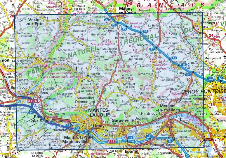
Wandelkaart - Topografische kaart 2113ET Mantes-la-Jolie, Boucles de la Seine | IGN - Institut Géographique National (9782758544838)
PNR du Vexin Francais

- ISBN / CODE: 9782758544838
- Editie: meest recente versie
- Schaal: 1:25000
- Uitgever: IGN - Institut Géographique National
- Soort: Topografische kaart, Wandelkaart
- Serie: Top 25
- Taal: Frans
- Bindwijze: -
- Uitvoering: Papier
- Schrijf als eerste een review
-
€ 16,95
Op voorraad. Voor 17.00 uur op werkdagen besteld, morgen in huis in Nederland Levertijd Belgie
Gratis verzending in Nederland vanaf €35,-
-
Topografische kaarten IGN 25.000 Parijs - Ile-de-France CENTRE: NOORDELIJK GEDEELTE


Producten op deze overzichtskaart:
Klik op een product om naar de pagina van dat product te gaan.
- Wandelkaart - Topografische kaart 1915SB Verneuil-sur-Avre, Bourth | IGN - Institut Géographique National
- Wandelkaart - Topografische kaart 1916SB La Loupe - Rémalard | IGN - Institut Géographique National
- Wandelkaart - Topografische kaart 1917SB Nogent-le-Rotrou, Thiron-Gardais | IGN - Institut Géographique National
- Wandelkaart - Topografische kaart 2015SB Dreux - Nonancourt | IGN - Institut Géographique National
- Wandelkaart - Topografische kaart 2016SB Chartres, Courville-sur-Eure | IGN - Institut Géographique National
- Wandelkaart - Topografische kaart 2017SB Illiers-Combray, Bailleau-le-Pin | IGN - Institut Géographique National
- Wandelkaart - Topografische kaart 2113ET Mantes-la-Jolie, Boucles de la Seine | IGN - Institut Géographique National
- Wandelkaart - Topografische kaart 2115SB Epernon | IGN - Institut Géographique National
- Wandelkaart - Topografische kaart 2116SB Maintenon | IGN - Institut Géographique National
- Wandelkaart - Topografische kaart 2117SB Voves - Sours | IGN - Institut Géographique National
- Wandelkaart - Topografische kaart 2214ET Versailles, Forêts de Marly et de St-Germain | IGN - Institut Géographique National
- Wandelkaart - Topografische kaart 2215OT Forêt de Rambouillet, PNR Haute-Vallée de Chevreuse | IGN - Institut Géographique National
- Wandelkaart - Topografische kaart 2216ET Etampes, Dourdan | IGN - Institut Géographique National
- Wandelkaart - Topografische kaart 2217SB Méréville - Sainville | IGN - Institut Géographique National
- Wandelkaart - Topografische kaart 2313OT Forêts de Montmorency de l'Isle-Adam et de Carnelle | IGN - Institut Géographique National
- Stadsplattegrond - Topografische kaart - Wandelkaart 2314OT Paris | IGN - Institut Géographique National
- Wandelkaart - Topografische kaart 2315OT Palaiseau - Arpajon, Forêt de Verrières | IGN - Institut Géographique National
- Wandelkaart - Topografische kaart 2316ET Milly-la-Forêt, Malesherbes, La Ferté-Alais | IGN - Institut Géographique National
- Wandelkaart - Topografische kaart 2318SB Pithiviers - Puiseaux | IGN - Institut Géographique National
- Wandelkaart - Topografische kaart 2413OT Dammartin-en-Goële, Centre | IGN - Institut Géographique National
- Wandelkaart - Topografische kaart 2414ET Marne-la-Vallée - Forêts: Crécy - Armainvilliers - Ferrières, Centre | IGN - Institut Géographique National
- Wandelkaart - Topografische kaart 2415OT Evry - Melun - Forêts | IGN - Institut Géographique National
- Wandelkaart - Topografische kaart 2416SB Melun, Mormant | IGN - Institut Géographique National
- Wandelkaart - Topografische kaart 2417OT Forêt de Fontainebleau | IGN - Institut Géographique National
- Wandelkaart - Topografische kaart 2513OT Meaux - Vallée de l'Ourcq, Centre | IGN - Institut Géographique National
- Wandelkaart - Topografische kaart 2514SB Meaux | IGN - Institut Géographique National
- Wandelkaart - Topografische kaart 2515SB Mormant, Rozay-en-Brie, Jouy-le-Châtel | IGN - Institut Géographique National
- Wandelkaart - Topografische kaart 2516SB Donnemarie-Dontilly, Nangis | IGN - Institut Géographique National
- Wandelkaart - Topografische kaart 2517SB Montereau-Fault-Yonne, Moret-Loing-et-Orvanne | IGN - Institut Géographique National
- Wandelkaart - Topografische kaart 2614SB La Ferté-Gaucher, Montmirail | IGN - Institut Géographique National
- Wandelkaart - Topografische kaart 2617SB Bray-sur-Seine | IGN - Institut Géographique National
-
Wandelkaarten IGN 25.000 Parijs - Ile-de-France CENTRE: NOORDELIJK GEDEELTE
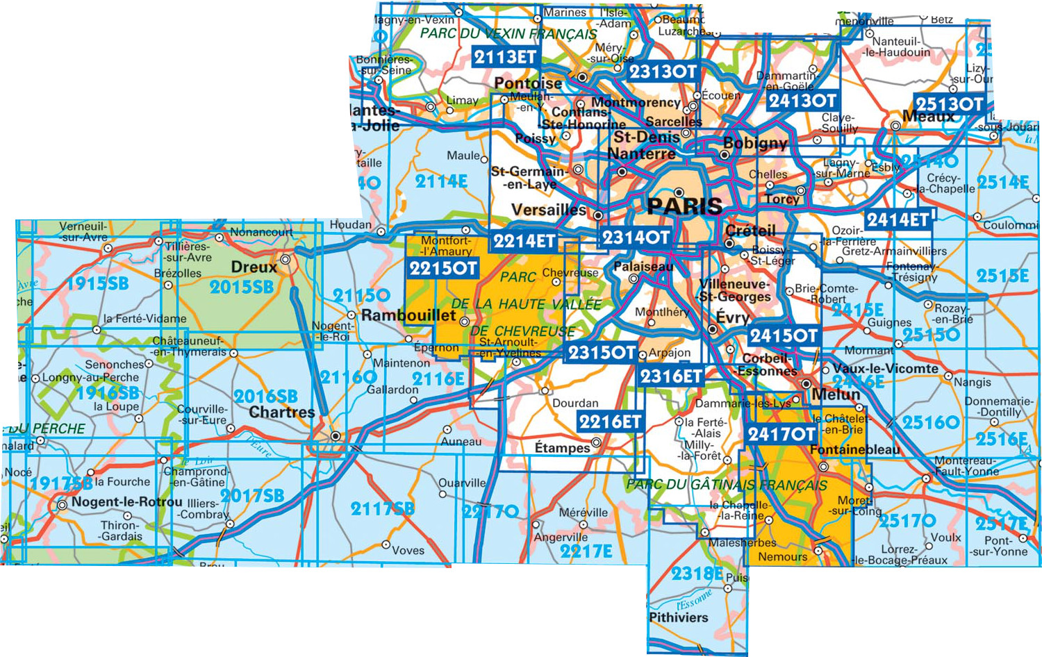
Producten op deze overzichtskaart:
Klik op een product om naar de pagina van dat product te gaan.
- Wandelkaart - Topografische kaart 1915SB Verneuil-sur-Avre, Bourth | IGN - Institut Géographique National
- Wandelkaart - Topografische kaart 1916SB La Loupe - Rémalard | IGN - Institut Géographique National
- Wandelkaart - Topografische kaart 1917SB Nogent-le-Rotrou, Thiron-Gardais | IGN - Institut Géographique National
- Wandelkaart - Topografische kaart 2015SB Dreux - Nonancourt | IGN - Institut Géographique National
- Wandelkaart - Topografische kaart 2016SB Chartres, Courville-sur-Eure | IGN - Institut Géographique National
- Wandelkaart - Topografische kaart 2017SB Illiers-Combray, Bailleau-le-Pin | IGN - Institut Géographique National
- Wandelkaart - Topografische kaart 2113ET Mantes-la-Jolie, Boucles de la Seine | IGN - Institut Géographique National
- Wandelkaart - Topografische kaart 2115SB Epernon | IGN - Institut Géographique National
- Wandelkaart - Topografische kaart 2116SB Maintenon | IGN - Institut Géographique National
- Wandelkaart - Topografische kaart 2117SB Voves - Sours | IGN - Institut Géographique National
- Wandelkaart - Topografische kaart 2214ET Versailles, Forêts de Marly et de St-Germain | IGN - Institut Géographique National
- Wandelkaart - Topografische kaart 2215OT Forêt de Rambouillet, PNR Haute-Vallée de Chevreuse | IGN - Institut Géographique National
- Wandelkaart - Topografische kaart 2216ET Etampes, Dourdan | IGN - Institut Géographique National
- Wandelkaart - Topografische kaart 2217SB Méréville - Sainville | IGN - Institut Géographique National
- Wandelkaart - Topografische kaart 2313OT Forêts de Montmorency de l'Isle-Adam et de Carnelle | IGN - Institut Géographique National
- Stadsplattegrond - Topografische kaart - Wandelkaart 2314OT Paris | IGN - Institut Géographique National
- Wandelkaart - Topografische kaart 2315OT Palaiseau - Arpajon, Forêt de Verrières | IGN - Institut Géographique National
- Wandelkaart - Topografische kaart 2316ET Milly-la-Forêt, Malesherbes, La Ferté-Alais | IGN - Institut Géographique National
- Wandelkaart - Topografische kaart 2318SB Pithiviers - Puiseaux | IGN - Institut Géographique National
- Wandelkaart - Topografische kaart 2413OT Dammartin-en-Goële, Centre | IGN - Institut Géographique National
- Wandelkaart - Topografische kaart 2414ET Marne-la-Vallée - Forêts: Crécy - Armainvilliers - Ferrières, Centre | IGN - Institut Géographique National
- Wandelkaart - Topografische kaart 2415OT Evry - Melun - Forêts | IGN - Institut Géographique National
- Wandelkaart - Topografische kaart 2416SB Melun, Mormant | IGN - Institut Géographique National
- Wandelkaart - Topografische kaart 2417OT Forêt de Fontainebleau | IGN - Institut Géographique National
- Wandelkaart - Topografische kaart 2513OT Meaux - Vallée de l'Ourcq, Centre | IGN - Institut Géographique National
- Wandelkaart - Topografische kaart 2514SB Meaux | IGN - Institut Géographique National
- Wandelkaart - Topografische kaart 2515SB Mormant, Rozay-en-Brie, Jouy-le-Châtel | IGN - Institut Géographique National
- Wandelkaart - Topografische kaart 2516SB Donnemarie-Dontilly, Nangis | IGN - Institut Géographique National
- Wandelkaart - Topografische kaart 2517SB Montereau-Fault-Yonne, Moret-Loing-et-Orvanne | IGN - Institut Géographique National
- Wandelkaart - Topografische kaart 2614SB La Ferté-Gaucher, Montmirail | IGN - Institut Géographique National
- Wandelkaart - Topografische kaart 2617SB Bray-sur-Seine | IGN - Institut Géographique National
Overzichtskaarten
Beschrijving
Reviews
Geen reviews gevonden voor dit product.
Schrijf een review
Graag horen wij wat u van dit artikel vindt. Vindt u het goed, leuk, mooi, slecht, lelijk, onbruikbaar of erg handig: schrijf gerust alles op! Het is niet alleen leuk om te doen maar u informeert andere klanten er ook nog mee!
Ook interessant voor europa/frankrijk/loire-centre
-

Wandelkaart - Topografische kaart 21
€ 16,95Topografische kaarten Centre - Val de Loire -

Wandelkaart - Topografische kaart 21
€ 16,95Topografische kaarten Centre - Val de Loire -

Wandelkaart - Topografische kaart 22
€ 16,95Topografische kaarten Centre - Val de Loire -

Wandelkaart - Topografische kaart 26
€ 16,95Topografische kaarten Centre - Val de Loire -

Topografische kaart - Wandelkaart 20
€ 14,95Topografische kaarten Centre - Val de Loire