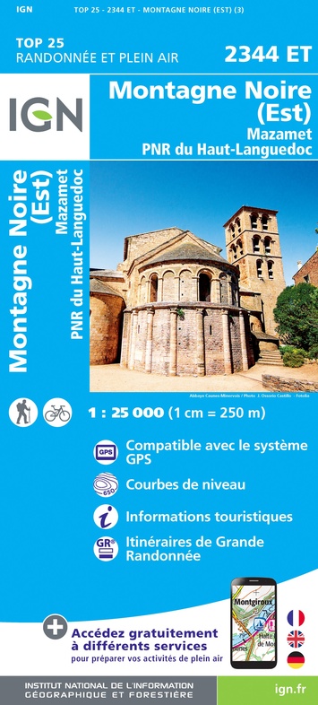
Wandelkaart - Topografische kaart 2344ET Montagne Noire est | IGN - Institut Géographique National (9782758543015)
Mazamet, PNR du Haut Languedoc
- ISBN / CODE: 9782758543015
- Editie: nieuwste editie
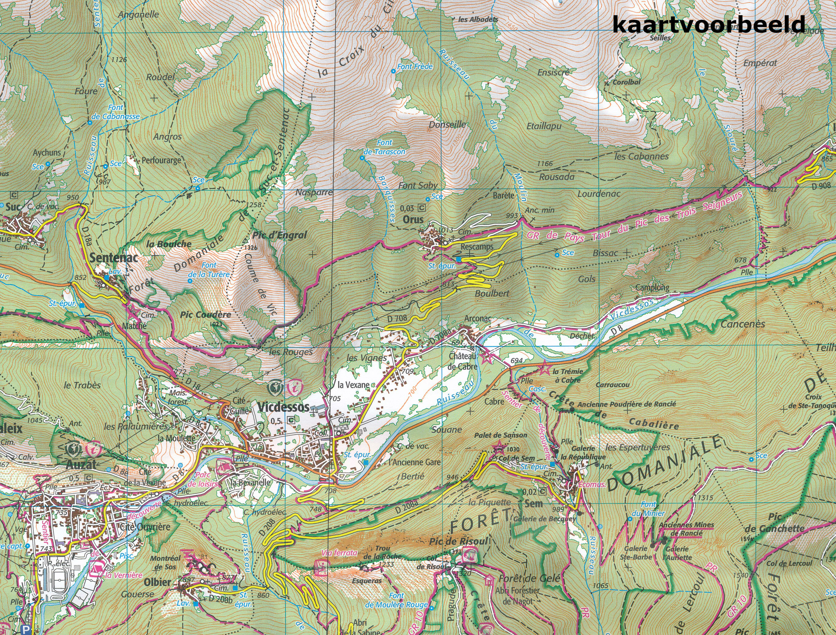
- Schaal: 1:25000
- Uitgever: IGN - Institut Géographique National
- Soort: Topografische kaart, Wandelkaart
- Serie: Top 25
- Taal: Frans
- Uitvoering: Papier
- Bindwijze: -
- Schrijf als eerste een review
-
€ 16,95
Op voorraad. Voor 17.00 uur op werkdagen besteld, morgen in huis in Nederland Levertijd Belgie
Gratis verzending in Nederland vanaf €35,-
-
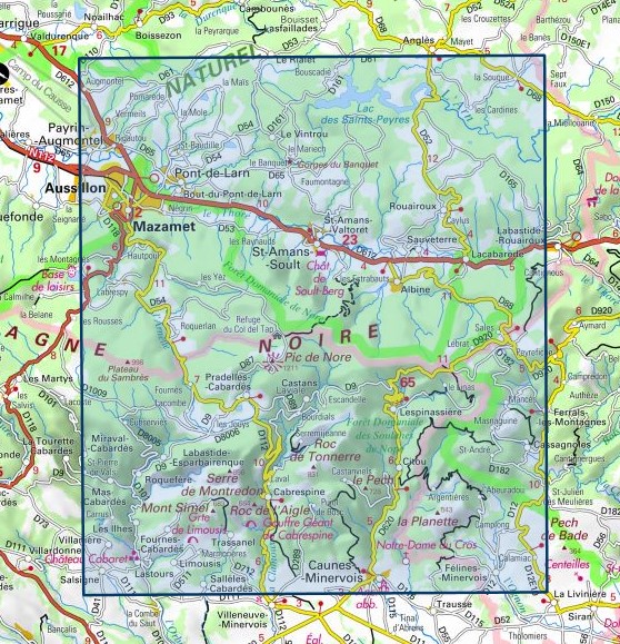
Topografische kaarten IGN 25.000 Languedoc -Rousillon
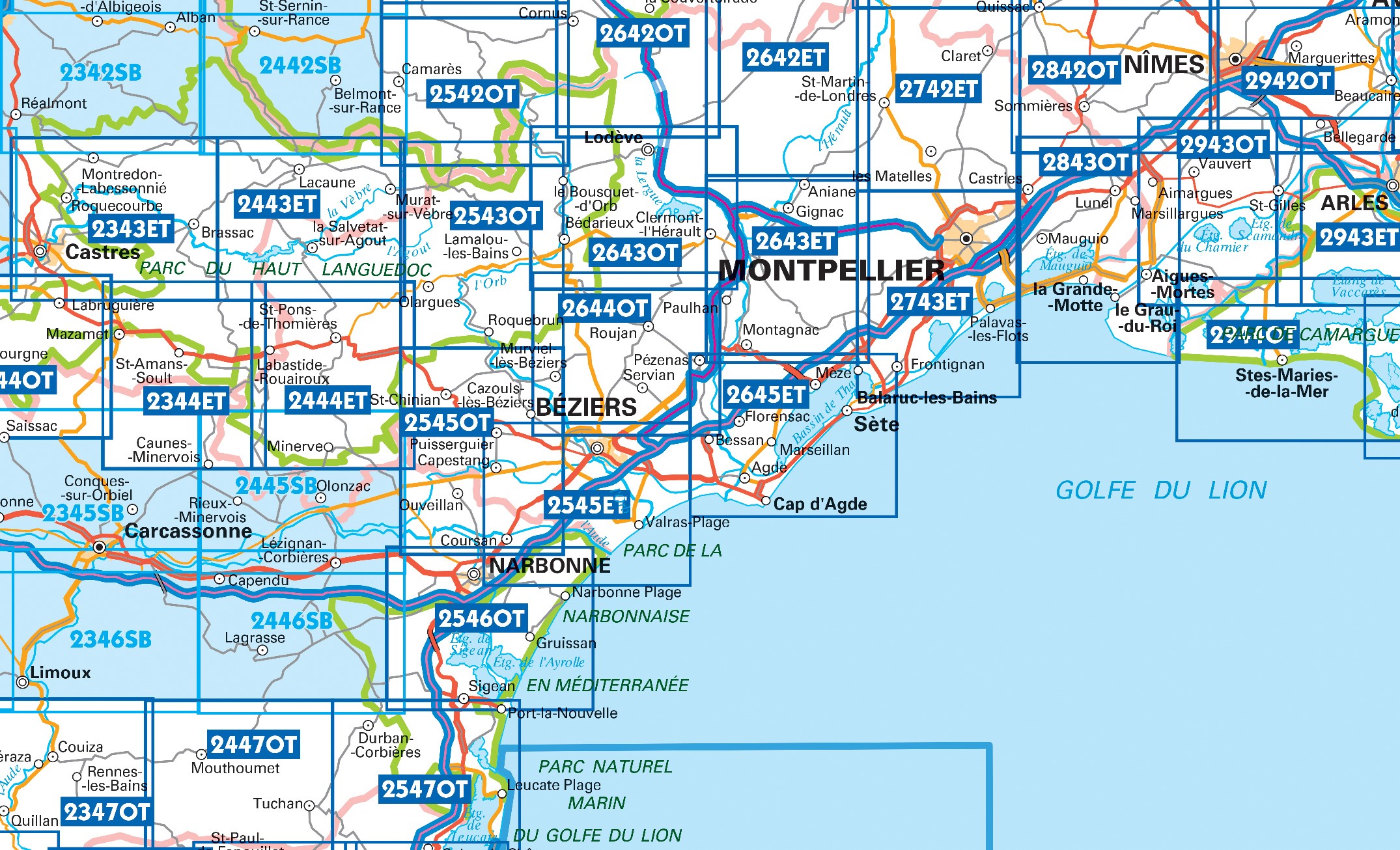
Producten op deze overzichtskaart:
Klik op een product om naar de pagina van dat product te gaan.
- Wandelkaart - Topografische kaart 2243SB Puylaurens, Lautrec | IGN - Institut Géographique National
- Wandelkaart - Topografische kaart 2342SB Réalmont - Alban | IGN - Institut Géographique National
- Wandelkaart - Topografische kaart 2343ET Castres, Sidobre, Brassac, Vebre, PNR du Haut Languedoc | IGN - Institut Géographique National
- Wandelkaart - Topografische kaart 2344ET Montagne Noire est | IGN - Institut Géographique National
- Wandelkaart - Topografische kaart 2344OT Montagne Noire (ouest) - Revel - Labrugiere - PNR du Haut Languedoc | IGN - Institut Géographique National
- Wandelkaart - Topografische kaart 2345SB Carcassonne - Alzonne | IGN - Institut Géographique National
- Wandelkaart - Topografische kaart 2346SB Cazilhac - Limoux | IGN - Institut Géographique National
- Wandelkaart - Topografische kaart 2442SB Belmont-sur-Rance, St-Sernin-sur-Rance | IGN - Institut Géographique National
- Wandelkaart - Topografische kaart 2443ET Monts de Lacaune, La Salvetat - sur - Agout, PNR du Haut Languedoc | IGN - Institut Géographique National
- Wandelkaart - Topografische kaart 2444ET Somail - Minervois | IGN - Institut Géographique National
- Wandelkaart - Topografische kaart 2445SB Lézignan - Corbieres, Rieux-Minervois | IGN - Institut Géographique National
- Wandelkaart - Topografische kaart 2446SB Ferrals-les-Corbières, Capendu | IGN - Institut Géographique National
- Wandelkaart - Topografische kaart 2542OT Camarès - Avène | IGN - Institut Géographique National
- Wandelkaart - Topografische kaart 2543OT Lamalou-les-Bains, Olargues, Roquebrun, Le Caroux, PNR du Haut Languedoc | IGN - Institut Géographique National
- Wandelkaart - Topografische kaart 2545OT St-Chinian - L'etang de Montady | IGN - Institut Géographique National
- Wandelkaart - Topografische kaart 2546OT Narbonne | IGN - Institut Géographique National
- Wandelkaart - Topografische kaart 2547OT Durban, Corbieres, Leucate, Plages du Roussillon | IGN - Institut Géographique National
- Wandelkaart - Topografische kaart 2642ET St.-Guilhem-le-Desert | IGN - Institut Géographique National
- Wandelkaart - Topografische kaart 2642OT Le Caylar - La Couvertoirade | IGN - Institut Géographique National
- Wandelkaart - Topografische kaart 2643ET Clermont-l'Hérault | IGN - Institut Géographique National
- Wandelkaart - Topografische kaart 2644OT Pézenas - Murviel-lès-Béziers | IGN - Institut Géographique National
- Wandelkaart - Topografische kaart 2645ET Cap d'Agde - Sète - Etang de Thau | IGN - Institut Géographique National
- Wandelkaart - Topografische kaart 2742ET St.-Martin-de-Londres, Ganges | IGN - Institut Géographique National
- Wandelkaart - Topografische kaart 2743ET Montpellier | IGN - Institut Géographique National
- Wandelkaart - Topografische kaart 2842OT Sommières, Vergèze | IGN - Institut Géographique National
- Wandelkaart - Topografische kaart 2843OT Aigues - Mortes - La Grande Motte | IGN - Institut Géographique National
- Wandelkaart - Topografische kaart 2943OT Saint-Gilles - Vauvert | IGN - Institut Géographique National
- Wandelkaart - Topografische kaart 2944OT Saintes-Maries-de-la-Mer | IGN - Institut Géographique National
-
Wandelkaarten IGN 25.000 Languedoc -Rousillon


Producten op deze overzichtskaart:
Klik op een product om naar de pagina van dat product te gaan.
- Wandelkaart - Topografische kaart 2243SB Puylaurens, Lautrec | IGN - Institut Géographique National
- Wandelkaart - Topografische kaart 2342SB Réalmont - Alban | IGN - Institut Géographique National
- Wandelkaart - Topografische kaart 2343ET Castres, Sidobre, Brassac, Vebre, PNR du Haut Languedoc | IGN - Institut Géographique National
- Wandelkaart - Topografische kaart 2344ET Montagne Noire est | IGN - Institut Géographique National
- Wandelkaart - Topografische kaart 2344OT Montagne Noire (ouest) - Revel - Labrugiere - PNR du Haut Languedoc | IGN - Institut Géographique National
- Wandelkaart - Topografische kaart 2345SB Carcassonne - Alzonne | IGN - Institut Géographique National
- Wandelkaart - Topografische kaart 2346SB Cazilhac - Limoux | IGN - Institut Géographique National
- Wandelkaart - Topografische kaart 2442SB Belmont-sur-Rance, St-Sernin-sur-Rance | IGN - Institut Géographique National
- Wandelkaart - Topografische kaart 2443ET Monts de Lacaune, La Salvetat - sur - Agout, PNR du Haut Languedoc | IGN - Institut Géographique National
- Wandelkaart - Topografische kaart 2444ET Somail - Minervois | IGN - Institut Géographique National
- Wandelkaart - Topografische kaart 2445SB Lézignan - Corbieres, Rieux-Minervois | IGN - Institut Géographique National
- Wandelkaart - Topografische kaart 2446SB Ferrals-les-Corbières, Capendu | IGN - Institut Géographique National
- Wandelkaart - Topografische kaart 2542OT Camarès - Avène | IGN - Institut Géographique National
- Wandelkaart - Topografische kaart 2543OT Lamalou-les-Bains, Olargues, Roquebrun, Le Caroux, PNR du Haut Languedoc | IGN - Institut Géographique National
- Wandelkaart - Topografische kaart 2545OT St-Chinian - L'etang de Montady | IGN - Institut Géographique National
- Wandelkaart - Topografische kaart 2546OT Narbonne | IGN - Institut Géographique National
- Wandelkaart - Topografische kaart 2547OT Durban, Corbieres, Leucate, Plages du Roussillon | IGN - Institut Géographique National
- Wandelkaart - Topografische kaart 2642ET St.-Guilhem-le-Desert | IGN - Institut Géographique National
- Wandelkaart - Topografische kaart 2642OT Le Caylar - La Couvertoirade | IGN - Institut Géographique National
- Wandelkaart - Topografische kaart 2643ET Clermont-l'Hérault | IGN - Institut Géographique National
- Wandelkaart - Topografische kaart 2643OT Lodeve | IGN - Institut Géographique National
- Wandelkaart - Topografische kaart 2644OT Pézenas - Murviel-lès-Béziers | IGN - Institut Géographique National
- Wandelkaart - Topografische kaart 2645ET Cap d'Agde - Sète - Etang de Thau | IGN - Institut Géographique National
- Wandelkaart - Topografische kaart 2742ET St.-Martin-de-Londres, Ganges | IGN - Institut Géographique National
- Wandelkaart - Topografische kaart 2743ET Montpellier | IGN - Institut Géographique National
- Wandelkaart - Topografische kaart 2842OT Sommières, Vergèze | IGN - Institut Géographique National
- Wandelkaart - Topografische kaart 2843OT Aigues - Mortes - La Grande Motte | IGN - Institut Géographique National
- Wandelkaart - Topografische kaart 2943OT Saint-Gilles - Vauvert | IGN - Institut Géographique National
- Wandelkaart - Topografische kaart 2944OT Saintes-Maries-de-la-Mer | IGN - Institut Géographique National
Overzichtskaarten
Beschrijving
Reviews
Geen reviews gevonden voor dit product.
Schrijf een review
Graag horen wij wat u van dit artikel vindt. Vindt u het goed, leuk, mooi, slecht, lelijk, onbruikbaar of erg handig: schrijf gerust alles op! Het is niet alleen leuk om te doen maar u informeert andere klanten er ook nog mee!
Ook interessant voor europa/frankrijk/languedoc-rousillon
-

Reisgids Michelin groene gids Langue
€ 25,99Reisgidsen Languedoc - Rousillon -
 - Revel - Labrugiere - PNR du Haut Languedoc | IGN - Institut Géographique National")
Wandelkaart - Topografische kaart 23
€ 16,95Topografische kaarten Languedoc - Rousillon -

Fietsgids Cycling the Canal Du Midi
€ 20,95Fietsgidsen Languedoc - Rousillon -

Wandelgids 812 La Haute Vallée du Th
€ 15,50Wandelgidsen Languedoc - Rousillon -

Campergids 22 Entdeckertouren mit de
€ 27,50Campergidsen Languedoc - Rousillon