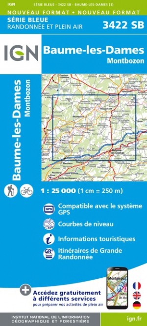
Wandelkaart - Topografische kaart 3422SB Baume-les-Dames | IGN - Institut Géographique National (9782758550174)
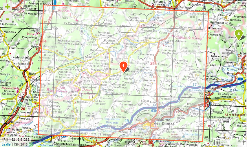
Montbozon
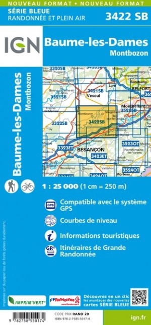
- ISBN / CODE: 9782758550174
- Editie: meest recente versie
- Schaal: 1:25000
- Uitgever: IGN - Institut Géographique National
- Soort: Topografische kaart, Wandelkaart
- Serie: Serie bleue
- Taal: Frans
- Uitvoering: Papier
- Bindwijze: -
- Schrijf als eerste een review
-
€ 16,95
Leverbaar in 3 - 5 werkdagen in huis in Nederland Levertijd Belgie
Gratis verzending in Nederland vanaf €35,-
-
Topografische kaarten IGN 25.000 Jura : Noord
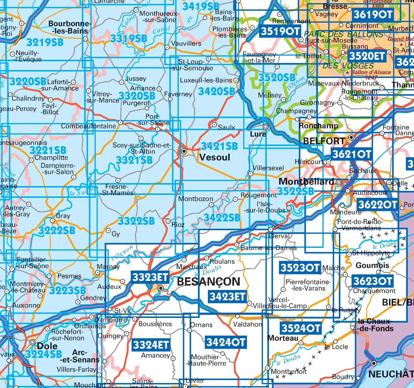
Producten op deze overzichtskaart:
Klik op een product om naar de pagina van dat product te gaan.
- Topografische kaart - Wandelkaart 3220SB Fayl-Billot | IGN - Institut Géographique National
- Topografische kaart - Wandelkaart 3221SB Champlitte | IGN - Institut Géographique National
- Wandelkaart - Topografische kaart 3222SB Gray - Autrey-lès-Gray | IGN - Institut Géographique National
- Wandelkaart - Topografische kaart 3223SB Pesmes - Gendrey | IGN - Institut Géographique National
- Wandelkaart - Topografische kaart 3224SB Dole | IGN - Institut Géographique National
- Wandelkaart - Topografische kaart 3319SB Monthureux-sur-Saône - Voisey | IGN - Institut Géographique National
- Wandelkaart - Topografische kaart 3320SB Jussey - Faverney | IGN - Institut Géographique National
- Wandelkaart - Topografische kaart 3321SB Port-sur-Saône, Fresne-St-Mamès | IGN - Institut Géographique National
- Wandelkaart - Topografische kaart 3322SB Gy - Rioz | IGN - Institut Géographique National
- Wandelkaart - Topografische kaart 3323ET Besançon - Forêt de Chailluz | IGN - Institut Géographique National
- Wandelkaart - Topografische kaart 3324ET Arc-et-Senans | IGN - Institut Géographique National
- Wandelkaart - Topografische kaart 3420SB Luxeuil-les-Bains, Conflans-sur-Lanterne | IGN - Institut Géographique National
- Wandelkaart - Topografische kaart 3421SB Vesoul | IGN - Institut Géographique National
- Wandelkaart - Topografische kaart 3422SB Baume-les-Dames | IGN - Institut Géographique National
- Wandelkaart - Topografische kaart 3423ET Baumes-les-Dames, Vallee du Doubs | IGN - Institut Géographique National
- Wandelkaart - Topografische kaart 3424OT Ornans, Source de la Loue | IGN - Institut Géographique National
- Wandelkaart - Topografische kaart 3522SB L'Isle-sur-le-Doubs, Villersexel | IGN - Institut Géographique National
- Wandelkaart - Topografische kaart 3523OT Vallee-du-Desoubre | IGN - Institut Géographique National
- Wandelkaart - Topografische kaart 3524OT Morteau | IGN - Institut Géographique National
- Wandelkaart - Topografische kaart 3621OT Belfort - Montbeliard | IGN - Institut Géographique National
- Wandelkaart - Topografische kaart 3622OT Montbéliard | IGN - Institut Géographique National
- Wandelkaart - Topografische kaart 3623OT Maîche | IGN - Institut Géographique National
-
Wandelkaarten IGN 25.000 Jura : Noord

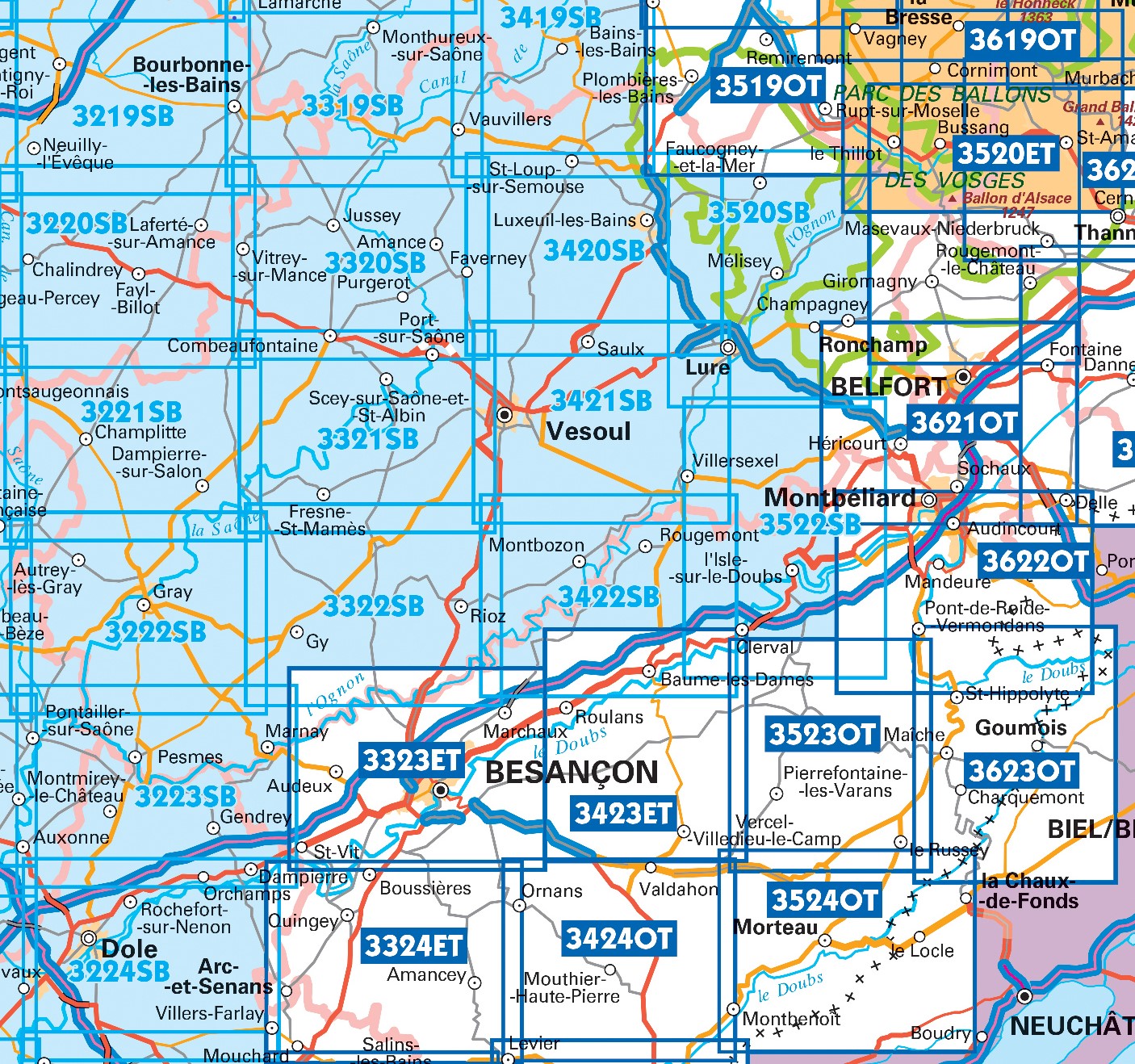
Producten op deze overzichtskaart:
Klik op een product om naar de pagina van dat product te gaan.
- Topografische kaart - Wandelkaart 3220SB Fayl-Billot | IGN - Institut Géographique National
- Topografische kaart - Wandelkaart 3221SB Champlitte | IGN - Institut Géographique National
- Wandelkaart - Topografische kaart 3222SB Gray - Autrey-lès-Gray | IGN - Institut Géographique National
- Wandelkaart - Topografische kaart 3223SB Pesmes - Gendrey | IGN - Institut Géographique National
- Wandelkaart - Topografische kaart 3224SB Dole | IGN - Institut Géographique National
- Wandelkaart - Topografische kaart 3319SB Monthureux-sur-Saône - Voisey | IGN - Institut Géographique National
- Wandelkaart - Topografische kaart 3320SB Jussey - Faverney | IGN - Institut Géographique National
- Wandelkaart - Topografische kaart 3321SB Port-sur-Saône, Fresne-St-Mamès | IGN - Institut Géographique National
- Wandelkaart - Topografische kaart 3322SB Gy - Rioz | IGN - Institut Géographique National
- Wandelkaart - Topografische kaart 3323ET Besançon - Forêt de Chailluz | IGN - Institut Géographique National
- Wandelkaart - Topografische kaart 3324ET Arc-et-Senans | IGN - Institut Géographique National
- Wandelkaart - Topografische kaart 3420SB Luxeuil-les-Bains, Conflans-sur-Lanterne | IGN - Institut Géographique National
- Wandelkaart - Topografische kaart 3421SB Vesoul | IGN - Institut Géographique National
- Wandelkaart - Topografische kaart 3422SB Baume-les-Dames | IGN - Institut Géographique National
- Wandelkaart - Topografische kaart 3423ET Baumes-les-Dames, Vallee du Doubs | IGN - Institut Géographique National
- Wandelkaart - Topografische kaart 3424OT Ornans, Source de la Loue | IGN - Institut Géographique National
- Wandelkaart - Topografische kaart 3522SB L'Isle-sur-le-Doubs, Villersexel | IGN - Institut Géographique National
- Wandelkaart - Topografische kaart 3523OT Vallee-du-Desoubre | IGN - Institut Géographique National
- Wandelkaart - Topografische kaart 3524OT Morteau | IGN - Institut Géographique National
- Wandelkaart - Topografische kaart 3621OT Belfort - Montbeliard | IGN - Institut Géographique National
- Wandelkaart - Topografische kaart 3622OT Montbéliard | IGN - Institut Géographique National
- Wandelkaart - Topografische kaart 3623OT Maîche | IGN - Institut Géographique National
Overzichtskaarten
Beschrijving
Reviews
Geen reviews gevonden voor dit product.
Schrijf een review
Graag horen wij wat u van dit artikel vindt. Vindt u het goed, leuk, mooi, slecht, lelijk, onbruikbaar of erg handig: schrijf gerust alles op! Het is niet alleen leuk om te doen maar u informeert andere klanten er ook nog mee!
Ook interessant voor europa/frankrijk/jura-1
-

Wandelkaart - Topografische kaart 32
€ 16,95Topografische kaarten Jura - Franche-Comte -

Reisgids Michelin groene gids Jura -
€ 25,99Reisgidsen Jura - Franche-Comte -

Wandelgids 901 Tours et traversées d
€ 19,95Wandelgidsen Jura - Franche-Comte -

Campergids Mit dem Wohnmobil in den
€ 23,50Campergidsen Jura - Franche-Comte -

Wegenkaart - landkaart - Fietskaart
€ 10,95Fietskaarten Jura - Franche-Comte