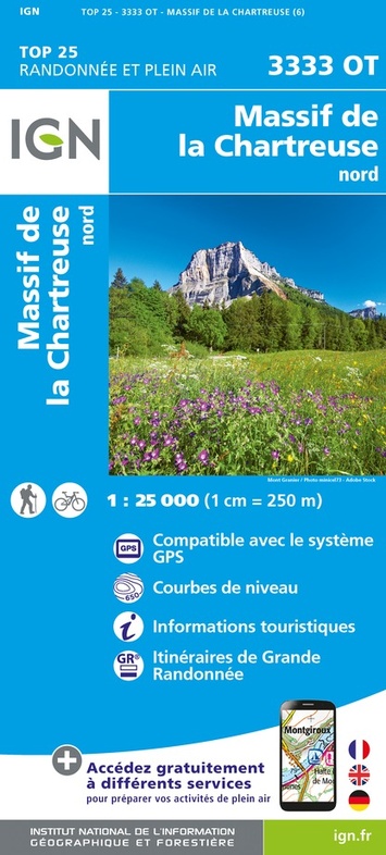
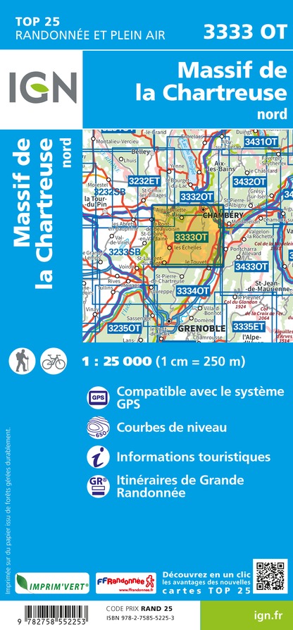
Wandelkaart - Topografische kaart 3333OT Massif de la Chartreuse Nord | IGN - Institut Géographique National (9782758552253)
- ISBN / CODE: 9782758552253
- Editie: nieuwste editie
- Schaal: 1:25000
- Uitgever: IGN - Institut Géographique National
- Soort: Topografische kaart, Wandelkaart
- Serie: Top 25
- Taal: Frans
- Uitvoering: Papier
- Bindwijze: -
- Beoordeling: 4,6 ★★★★★ ★★★★★ (5 reviews) Schrijf een review
-
€ 16,95
Op voorraad. Voor 17.00 uur op werkdagen besteld, morgen in huis in Nederland Levertijd Belgie
Gratis verzending in Nederland vanaf €35,-
.jpg)
-
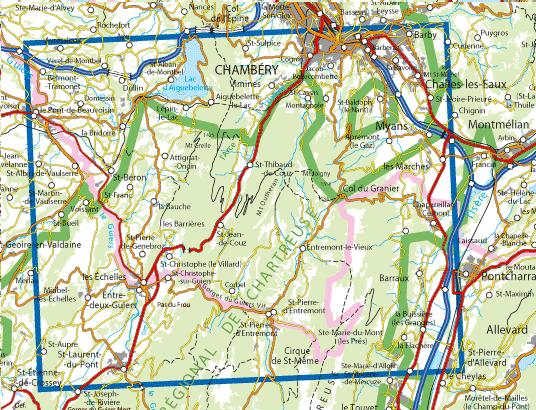
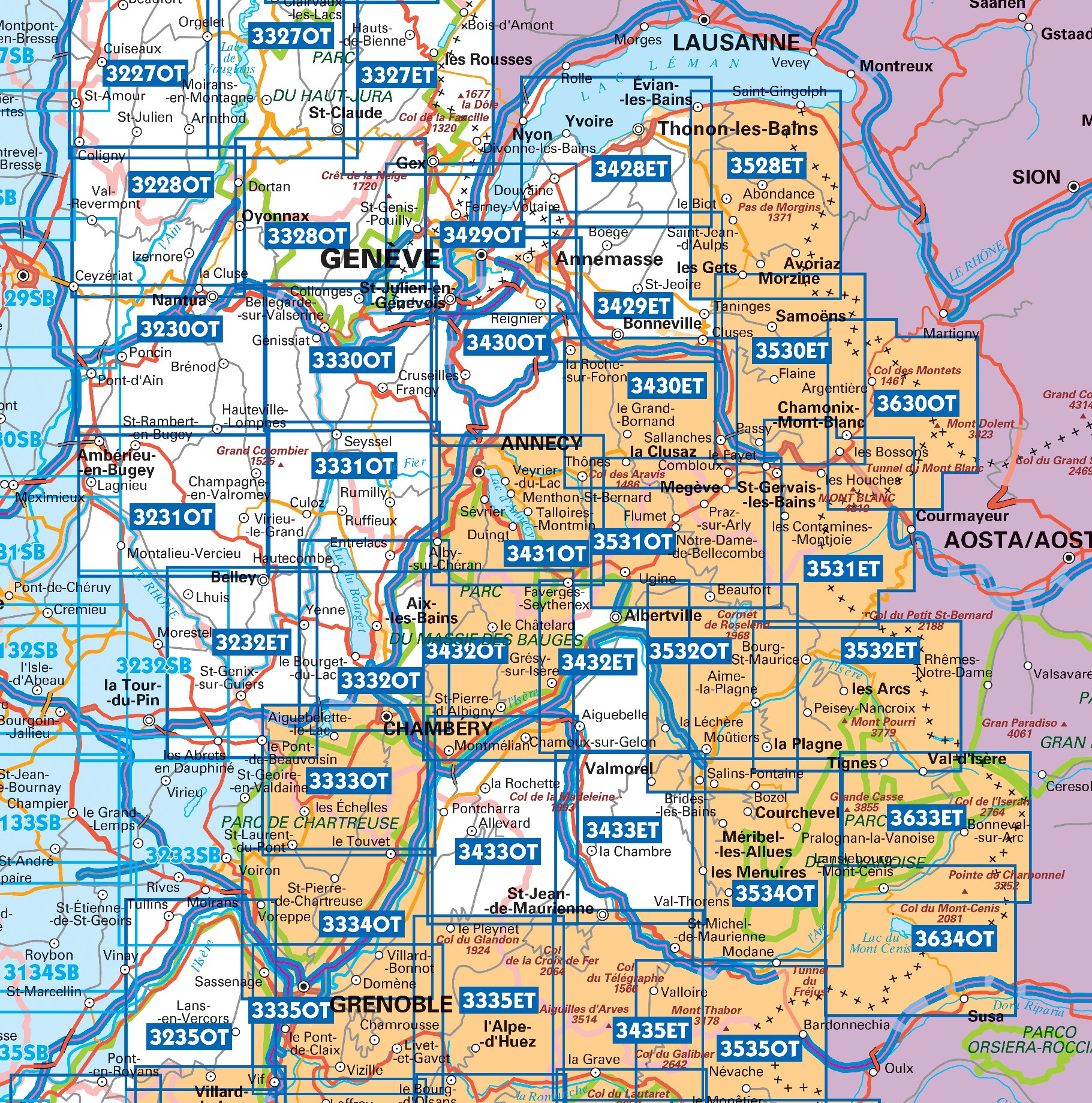
Topografische kaarten IGN 25.000 Savoie - Vanoise


Producten op deze overzichtskaart:
Klik op een product om naar de pagina van dat product te gaan.
- Topografische kaart - Wandelkaart 3233SB Le Grand-Lemps, Lac de Paladru, Voiron, Tullins | IGN - Institut Géographique National
- Wandelkaart - Topografische kaart 3333OT Massif de la Chartreuse Nord | IGN - Institut Géographique National
- Wandelkaart - Topografische kaart 3334OT Massif de la Chartreuse Sud | IGN - Institut Géographique National
- Wandelkaart - Topografische kaart 3335ET le Bourg d'Oisans - l'Alpe d'Huez | IGN - Institut Géographique National
- Wandelkaart - Topografische kaart 3335OT Grenoble | IGN - Institut Géographique National
- Wandelkaart - Topografische kaart 3335OTR Grenoble | IGN - Institut Géographique National
- Wandelkaart - Topografische kaart 3432ET Albertville | IGN - Institut Géographique National
- Wandelkaart - Topografische kaart 3432OT Massif des Bauges | IGN - Institut Géographique National
- Wandelkaart - Topografische kaart 3432OTR Massif des Bauges | IGN - Institut Géographique National
- Wandelkaart - Topografische kaart 3433ET Saint-Jean-de-Maurienne | IGN - Institut Géographique National
- Wandelkaart - Topografische kaart 3433OT Allevard | IGN - Institut Géographique National
- Wandelkaart - Topografische kaart 3435ET Valloire | IGN - Institut Géographique National
- Wandelkaart - Topografische kaart 3532ET les Arcs - la Plagne | IGN - Institut Géographique National
- Wandelkaart - Topografische kaart 3532OT Massif du Beaufortain | IGN - Institut Géographique National
- Wandelkaart - Topografische kaart 3534OT Les Trois Vallées | IGN - Institut Géographique National
- Wandelkaart - Topografische kaart 3535OT Névache - Mont Thabor | IGN - Institut Géographique National
- Wandelkaart - Topografische kaart 3633ET Tignes - Val d'Isère | IGN - Institut Géographique National
- Wandelkaart - Topografische kaart 3634OT Val Cenis | IGN - Institut Géographique National
-
Wandelkaarten IGN 25.000 Savoie - Vanoise
Producten op deze overzichtskaart:
Klik op een product om naar de pagina van dat product te gaan.
- Topografische kaart - Wandelkaart 3233SB Le Grand-Lemps, Lac de Paladru, Voiron, Tullins | IGN - Institut Géographique National
- Wandelkaart - Topografische kaart 3333OT Massif de la Chartreuse Nord | IGN - Institut Géographique National
- Wandelkaart - Topografische kaart 3334OT Massif de la Chartreuse Sud | IGN - Institut Géographique National
- Wandelkaart - Topografische kaart 3335ET le Bourg d'Oisans - l'Alpe d'Huez | IGN - Institut Géographique National
- Wandelkaart - Topografische kaart 3335OT Grenoble | IGN - Institut Géographique National
- Wandelkaart - Topografische kaart 3335OTR Grenoble | IGN - Institut Géographique National
- Wandelkaart - Topografische kaart 3432ET Albertville | IGN - Institut Géographique National
- Wandelkaart - Topografische kaart 3432OT Massif des Bauges | IGN - Institut Géographique National
- Wandelkaart - Topografische kaart 3432OTR Massif des Bauges | IGN - Institut Géographique National
- Wandelkaart - Topografische kaart 3433ET Saint-Jean-de-Maurienne | IGN - Institut Géographique National
- Wandelkaart - Topografische kaart 3433OT Allevard | IGN - Institut Géographique National
- Wandelkaart - Topografische kaart 3435ET Valloire | IGN - Institut Géographique National
- Wandelkaart - Topografische kaart 3532ET les Arcs - la Plagne | IGN - Institut Géographique National
- Wandelkaart - Topografische kaart 3532OT Massif du Beaufortain | IGN - Institut Géographique National
- Wandelkaart - Topografische kaart 3534OT Les Trois Vallées | IGN - Institut Géographique National
- Wandelkaart - Topografische kaart 3535OT Névache - Mont Thabor | IGN - Institut Géographique National
- Wandelkaart - Topografische kaart 3633ET Tignes - Val d'Isère | IGN - Institut Géographique National
- Wandelkaart - Topografische kaart 3634OT Val Cenis | IGN - Institut Géographique National
Overzichtskaarten
Beschrijving
Reviews
Prima geo-kaarten van IGN van elke Franse regio. Zwerver levert snel en goed.
★★★★★ door jos 7 september 2023 | Heeft dit artikel gekochtVond u dit een nuttige review? (login om te beoordelen)
Anders dan bij meer populaire wandelgebieden is de markering op de paden (GR, GRP, Chemin d Assise) zomer 2023 soms slecht. De kaart is dan nuttig. Controleer op internet of de campings aangegeven op de kaart nog bestaan.
★★★★★ door J. 23 augustus 2023 | Heeft dit artikel gekochtVond u dit een nuttige review? (login om te beoordelen)
prima aangekomen en snel as zaterdag ga ik samen met mijn 6 andere wandelgenoten de kaart testen in de Chartreuse. We doen een 6 daagse tour, kamperen wild met vaak een kampvuurtje ( t is al koud 's avonds). Het Franse platteland is al flink ontvolkt in de 30 jaar dat we dit nu doen. Dus veel zullen winkels kroegen zullen we niet tegenkomen.
★★★★★ door Ellen Vroon 18 oktober 2013Vond u dit een nuttige review? (login om te beoordelen)
Schrijf een review
Graag horen wij wat u van dit artikel vindt. Vindt u het goed, leuk, mooi, slecht, lelijk, onbruikbaar of erg handig: schrijf gerust alles op! Het is niet alleen leuk om te doen maar u informeert andere klanten er ook nog mee!
Ook interessant voor europa/frankrijk/franse-alpen
-

Wandelgids 530 La Vanoise Parc natio
€ 19,95Wandelgidsen Franse Alpen -

Campergids 91 Französische Alpen - F
€ 25,50Campergidsen Franse Alpen -

Natuurgids Alpine Flowers - bloemeng
€ 15,95Natuurgidsen Duitse Alpen gebied -

Fietskaart - Wegenkaart - landkaart
€ 10,95Fietskaarten Franse Alpen -

Reisgids ANWB extra Franse Alpen | A
€ 15,50Reisgidsen Franse Alpen