Winkelwagen
Geen items in winkelwagen
Ga naar winkelwagen
Wandelkaarten - Ardeche - Rhone Vallei
Overzichtskaarten
-
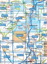
Wandelkaarten IGN 25.000 Ardeche - Rhone vallei Noord


Producten op deze overzichtskaart:
Klik op een product om naar de pagina van dat product te gaan.
- Wandelkaart - Topografische kaart 2733SB St-Anthème, Arlanc | IGN - Institut Géographique National
- Wandelkaart - Topografische kaart 2831SB Feurs – Boën-sur-Lignon | IGN - Institut Géographique National
- Wandelkaart - Topografische kaart 2832SB Montbrison - Veauche | IGN - Institut Géographique National
- Wandelkaart - Topografische kaart 2833SB Firminy, St-Bonnet-le-Château | IGN - Institut Géographique National
- Wandelkaart - Topografische kaart 2834SB Monistrol-sur-Loire, Retournac | IGN - Institut Géographique National
- Wandelkaart - Topografische kaart 2835OT Le Puy-en-Velay | IGN - Institut Géographique National
- Wandelkaart - Topografische kaart 2930ET Villefranche-sur-Saône | IGN - Institut Géographique National
- Wandelkaart - Topografische kaart 2931ET L'Arbresle - Monts de Tarare – Col de la Luère – Rhônevallei - Bourgondië | IGN - Institut Géographique National
- Wandelkaart - Topografische kaart 2932ET Monts du Lyonnais | IGN - Institut Géographique National
- Wandelkaart - Topografische kaart 2933ET Massif du Pilat - St-Etienne - St-Chamond - PNR du Pilat Ardéche | IGN - Institut Géographique National
- Wandelkaart - Topografische kaart 2934ET Bourg-Argental - Col de la République - PNR du Pilat Ardéche | IGN - Institut Géographique National
- Wandelkaart - Topografische kaart 2935OT Le Chambon-sur-Lignon - St-Agrève Ardéche | IGN - Institut Géographique National
- Wandelkaart - Topografische kaart 3030SB Villars-les-Dombes – Villefranche-sur-Saône | IGN - Institut Géographique National
- Wandelkaart - Topografische kaart 3031OT Lyon - Villeurbanne - Mont d'Or | IGN - Institut Géographique National
- Wandelkaart - Topografische kaart 3032SB Vénissieux, Oullins, Givors | IGN - Institut Géographique National
- Wandelkaart - Topografische kaart 3033SB Roussillon, Vienne | IGN - Institut Géographique National
- Wandelkaart - Topografische kaart 3034SB Serrières | IGN - Institut Géographique National
- Wandelkaart - Topografische kaart 3035SB Tounon-sur-Rhône – Satillieu | IGN - Institut Géographique National
- Wandelkaart - Topografische kaart 3130SB Ambérieu-en-Bugey | IGN - Institut Géographique National
- Wandelkaart - Topografische kaart 3131SB Meyzieu | IGN - Institut Géographique National
- Wandelkaart - Topografische kaart 3132SB Bourgoin-Jallieu - La Velpillere | IGN - Institut Géographique National
- Wandelkaart - Topografische kaart 3133SB La Côte-St-André – St-Jean-de-Bournay | IGN - Institut Géographique National
- Wandelkaart - Topografische kaart 3134SB St-Etienne-de-St-Geoirs – Le Grand-Serre | IGN - Institut Géographique National
- Topografische kaart - Wandelkaart 3135SB Romans-sur-Isère, St-Marcellin | IGN - Institut Géographique National
-
Wandelkaarten IGN 25.000 Ardeche - Rhone vallei ZUIDELIJK GEDEELTE
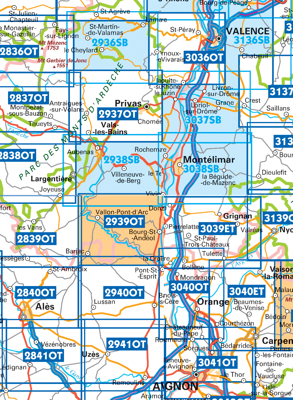
Producten op deze overzichtskaart:
Klik op een product om naar de pagina van dat product te gaan.
- Wandelkaart - Topografische kaart 2836OT Gerbier de Jonc | IGN - Institut Géographique National
- Wandelkaart - Topografische kaart 2837OT Lac d'Issarlès - Thueyts | IGN - Institut Géographique National
- Wandelkaart - Topografische kaart 2838OT Largentière | IGN - Institut Géographique National
- Wandelkaart - Topografische kaart 2839OT Besseges - Les-Vans | IGN - Institut Géographique National
- Wandelkaart - Topografische kaart 2840OT Ales | IGN - Institut Géographique National
- Wandelkaart - Topografische kaart 2841OT Vézénobres | IGN - Institut Géographique National
- Topografische kaart - Wandelkaart 2936SB le Cheylard | IGN - Institut Géographique National
- Wandelkaart - Topografische kaart 2937OT Privas – Vals-les-Bains | IGN - Institut Géographique National
- Wandelkaart - Topografische kaart 2938SB Largentière, Aubenas, Villeneuve-de-Berg | IGN - Institut Géographique National
- Wandelkaart - Topografische kaart 2939OT Gorges de l'Ardèche | IGN - Institut Géographique National
- Wandelkaart - Topografische kaart 2940OT Bagnols-sur-Cèze | IGN - Institut Géographique National
- Wandelkaart - Topografische kaart 2941OT Uzès - Remoulins | IGN - Institut Géographique National
- Wandelkaart - Topografische kaart 2942OT Nîmes | IGN - Institut Géographique National
- Topografische kaart - Wandelkaart 3036OT Valence | IGN - Institut Géographique National
- Wandelkaart - Topografische kaart 3037SB Crest – La Voulte-sur-Rhône | IGN - Institut Géographique National
- Wandelkaart - Topografische kaart 3038SB Montélimar | IGN - Institut Géographique National
- Wandelkaart - Topografische kaart 3039ET Valréas | IGN - Institut Géographique National
- Wandelkaart - Topografische kaart 3040OT Orange | IGN - Institut Géographique National
- Wandelkaart - Topografische kaart 3041OT Avignon | IGN - Institut Géographique National
- Wandelkaart - Topografische kaart 3136SB Bourg-de-Péage – Chabeuil | IGN - Institut Géographique National
 Wandelkaart - Topografische kaart 3031OT Lyon - Villeurbanne - Mont d'Or | IGN - Institut Géographique National
 Wandelkaart - Topografische kaart 2935OT Le Chambon-sur-Lignon - St-Agrève Ardéche | IGN - Institut Géographique National
 Wandelkaart - Topografische kaart 2934ET Bourg-Argental - Col de la République - PNR du Pilat Ardéche | IGN - Institut Géographique National
 Wandelkaart - Topografische kaart 2933ET Massif du Pilat - St-Etienne - St-Chamond - PNR du Pilat Ardéche | IGN - Institut Géographique National
 Wandelkaart - Topografische kaart 2932ET Monts du Lyonnais | IGN - Institut Géographique National
 Wandelkaart - Topografische kaart 2931ET L'Arbresle - Monts de Tarare – Col de la Luère – Rhônevallei - Bourgondië | IGN - Institut Géographique National
 Wandelkaart - Topografische kaart 2930ET Villefranche-sur-Saône | IGN - Institut Géographique National
 Wandelkaart - Topografische kaart 2835OT Le Puy-en-Velay | IGN - Institut Géographique National
 Wandelkaart - Topografische kaart 3030SB Villars-les-Dombes – Villefranche-sur-Saône | IGN - Institut Géographique National
 Wandelkaart - Topografische kaart 3130SB Ambérieu-en-Bugey | IGN - Institut Géographique National
 Wandelkaart - Topografische kaart 2831SB Feurs – Boën-sur-Lignon | IGN - Institut Géographique National
 Wandelkaart - Topografische kaart 3131SB Meyzieu | IGN - Institut Géographique National
 Wandelkaart - Topografische kaart 2832SB Montbrison - Veauche | IGN - Institut Géographique National
 Wandelkaart - Topografische kaart 3032SB Vénissieux, Oullins, Givors | IGN - Institut Géographique National★★★★★
 Wandelkaart - Topografische kaart 3132SB Bourgoin-Jallieu - La Velpillere | IGN - Institut Géographique National
 Wandelkaart - Topografische kaart 2733SB St-Anthème, Arlanc | IGN - Institut Géographique National
 Wandelkaart - Topografische kaart 2833SB Firminy, St-Bonnet-le-Château | IGN - Institut Géographique National
 Wandelkaart - Topografische kaart 3033SB Roussillon, Vienne | IGN - Institut Géographique National
 Wandelkaart - Topografische kaart 3133SB La Côte-St-André – St-Jean-de-Bournay | IGN - Institut Géographique National
 Wandelkaart - Topografische kaart 2834SB Monistrol-sur-Loire, Retournac | IGN - Institut Géographique National
Laatste reviews

Snel bijzonder
Nergens te krijgen. Een gids van Austin Texas. Maar hier dus mooi wel! Snel geleverd en nou ja niet echt te duur.
★★★★★ door Joop 23 april 2024 | Heeft dit artikel gekocht
Heel veel wandeltocht-info + een goede kaart voor prima bedrag
Practische wandelgids over Bregenzerwald en Grosses Walsertal met heel veel info en goede tochtbeschrijvingen. Wel zwaar kwa gewicht, maar wandelend neem je alleen de 1:40.000-wandelkaart …
★★★★★ door Maarten 23 april 2024 | Heeft dit artikel gekocht
Prettig leesbaar, informatief boek
Dit boek voldoet aan onze wensen als wij door dit land gaan trekken: achtergronden, historie, natuur en cultuurwetenswaardigheden en toeristische info.
★★★★★ door Ria Kapteijn 23 april 2024 | Heeft dit artikel gekocht
Prima, goed gedetailleerd boek over Rhodos
Meest uitgebreide reisgids over Rhodos. Ben zeer tevreden. Ook andere reisgidsen van deze schrijver over Griekse eilanden bevallen ons goed.
★★★★★ door Rene vierbergen 22 april 2024 | Heeft dit artikel gekocht